|
Mars Exploration Rover Mission |
|
|
|
|
|
|
|
|
|
|
|
|
|
|
|
|
|
Other Martian Missions |
|
| |
Mars Topics |
|
|
|
Moons of Mars |
Deimos,
Phobos
|
|
The Best of Mars Spirit Lander Images
This gallery is designed to show some of the best Spirit Rover Mission Images.
 Summit Panorama with Rover Deck
The panoramic camera on NASA's Mars Exploration Rover Spirit took the
hundreds of images combined into this 360-degree view, the "Husband Hill
Summit" panorama. The images were acquired on Spirit's sols 583 to 586
(Aug. 24 to 27, 2005), shortly after the rover reached the crest of
"Husband Hill" inside Mars' Gusev Crater. This is the largest panorama
yet acquired from either Spirit or Opportunity. The panoramic camera shot
653 separate images in 6 different filters, encompassing the rover's deck
and the full 360 degrees of surface rocks and soils visible to the camera
from this position. This is the first time the camera has been used to
image the entire rover deck and visible surface from the same position.
Stitching together of all the images took significant effort because of
the large changes in resolution and parallax across the scene.
The image is an approximately true-color rendering using the
750-nanometer, 530-nanometer and 480-nanometer filters for the surface,
and the 600-nanometer and 480-nanometer filters for the rover deck.
Image-to-image seams have been eliminated from the sky portion of the
mosaic to better simulate the vista a person standing on Mars would see.
This panorama provided the team's first view of the "Inner Basin" region
(center of the image), including the enigmatic "Home Plate" feature seen
from orbital data. After investigating the summit area, Spirit drove
downhill to get to the Inner Basin region. Spirit arrived at the summit
from the west, along the direction of the rover tracks seen in the middle
right of the panorama. The peaks of "McCool Hill" and "Ramon Hill" can be
seen on the horizon near the center of the panorama. The summit region
itself is a broad, windswept plateau. Spirit spent more than a month
exploring the summit region, measuring the chemistry and mineralogy of
soils and rocky outcrops at the peak of Husband Hill for comparison with
similar measurements obtained during the ascent.
(Courtesy NASA/JPL-Caltech/Cornell)
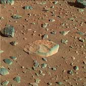 Sailing to White Boat
This is a composite red-green-blue image of the rock called White Boat. It is the
first rock target that Spirit drove to after finishing a series of investigations
on the rock Adirondack. White Boat stood out to scientists due to its light color
and more tabular shape compared to the dark, rounded rocks that surround it.
(Courtesy NASA/JPL/Cornell
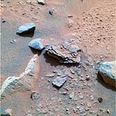 Flaky "Mimi"
This color image taken by the Mars Exploration Rover Spirit's panoramic camera on
Sol 40 is centered on an unusually flaky rock called Mimi. Mimi is only one of many
features in the area known as "Stone Council," but looks very different from any
rock that scientists have seen at the Gusev crater site so far. Mimi's flaky
appearance leads scientists to a number of hypotheses. Mimi could have been
subjected to pressure either through burial or impact, or may have once been a
dune that was cemented into flaky layers, a process that sometimes involves the
action of water.
(Courtesy NASA/JPL/Cornell
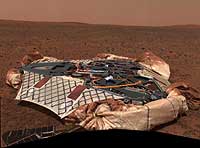 Empty Nest
This image mosaic taken by the panoramic camera onboard the Mars
Exploration Rover Spirit shows the rover's landing site, the Columbia
Memorial Station, at Gusev Crater, Mars. This spectacular view may
encapsulate Spirit's entire journey, from lander to its possible final
destination toward the east hills. On its way, the rover will travel 250
meters (820 feet) northeast to a large crater approximately 200 meters
(660 feet) across, the ridge of which can be seen to the left of this
image. To the right are the east hills, about 3 kilometers (2 miles)
away from the lander. The picture was taken on the 16th martian day, or
sol, of the mission (Jan. 18/19, 2004). A portion of Spirit's solar
panels appear in the foreground. Data from the panoramic camera's green,
blue and infrared filters were combined to create this approximate
true color image.
(Courtesy NASA/JPL/Cornell)
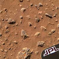 The Mystery Soil
This high-resolution image from the panoramic camera on the Mars Exploration
Rover Spirit shows the region containing the patch of soil scientists examined
at Gusev Crater just after Spirit rolled off the Columbia Memorial Station.
Scientists examined this patch on the 13th and 15th martian days, or sols,
of Spirit's journey. Using nearly all the science instruments located on the
rover's instrument deployment device or "arm," scientists yielded some puzzling
results including the detection of a mineral called olivine and the appearance
that the soil is stronger and more cohesive than they expected. Like detectives
searching for clues, the science team will continue to peruse the landscape for
explanations of their findings.
Data taken from the camera's red, green and blue filters were combined to
create this approximate true color picture, acquired on the 12th martian day,
or sol, of Spirit's journey.
(Courtesy NASA/JPL/Cornell)
 They of the Great Rocks
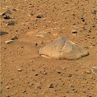
This approximate true color image taken by the panoramic camera onboard the Mars Exploration Rover Spirit shows "Adirondack," the rover's first target rock. Spirit traversed the sandy martian terrain at Gusev Crater to arrive in front of the football-sized rock on Sunday, Jan. 18, 2004, just three days after it successfully rolled off the lander. The rock was selected as Spirit's first target because its dust-free, flat surface is ideally suited for grinding. Clean surfaces also are better for examining a rock's top coating. Scientists named the angular rock after the Adirondack mountain range in New York. The word Adirondack is Native American and means "They of the great rocks.
(Courtesy NASA/JPL/Cornell)
 Rocks: Windows to History of Mars
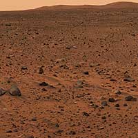
This full-resolution image taken by the panoramic camera onboard the Mars Exploration Rover Spirit before it rolled off the lander shows the rocky surface of Mars. Scientists are eager to begin examining the rocks because, unlike soil, these "little time capsules" hold memories of the ancient processes that formed them. The lander's deflated airbags can be seen in the foreground. Data from the camera's red, green and blue filters were combined to create this approximate true color picture.
(Courtesy NASA/JPL/Cornell)
 Spirit Looks Back
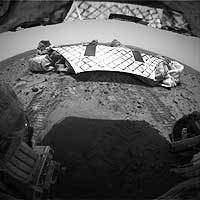
This image from the Mars Exploration Rover Spirit's rear hazard identification camera shows the rover's hind view of the lander platform, its nest for the past 12 sols, or martian days. The rover is approximately 1 meter (3 feet) in front of the airbag-cushioned lander, facing northwest. Note the tracks left in the martian soil by the rovers' wheels, all six of which have rolled off the lander. This is the first time the rover has touched martian soil.
(Courtesy NASA/JPL/Cornell)
 Spirit Is Out the Gate
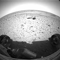
JPL engineers played Baha Men's "Who Let the Dogs Out" in the control
room as they watched new images confirming that the Mars Exploration Rover
Spirit successfully rolled off its lander platform early Thursday morning.
This image from the rover's front hazard identification camera shows the
rover's view of the martian landscape from its new position 1 meter
(3 feet) northwest of the lander. One of the rover's next tasks will be
to locate the Sun with its panoramic camera and calculate from the Sun's
position how to point its main antenna toward Earth.
(Courtesy NASA/JPL/Cornell)
 360 Degree Color Panorama
This is a medium-resolution version of the first 360-degree panoramic view of
the martian surface, taken on Mars by the Mars Exploration Rover Spirit's panoramic
camera. Part of the spacecraft can be seen in the lower corner regions.
The color panorama is a mosaic stitched from 225 frames taken by Spirit's panoramic
camera. It spans 75 frames across, three frames tall, with color information from
shots through three different filters.
(Courtesy NASA/JPL/Cornell)
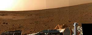 Martian Surface at an Angle
This latest color "postcard from Mars," taken on Sol 5 by the panoramic camera
on the Mars Exploration Rover Spirit, looks to the north. The apparent slope of
the horizon is due to the several-degree tilt of the lander deck. On the left,
the circular topographic feature dubbed Sleepy Hollow can be seen along with
dark markings that may be surface disturbances caused by the airbag-encased
lander as it bounced and rolled to rest. A dust-coated airbag is prominent in
the foreground, and a dune-like object that has piqued the interest of the
science team with its dark, possibly armored top coating, can be seen on the right.
(Courtesy NASA/JPL/Cornell)
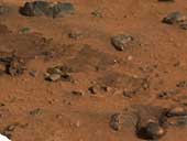 Airbag Trails
This segment of the first color image from the panoramic camera on the Mars
Exploration Rover Spirit shows the rover's airbag trails. These depressions
in the soil were made when the airbags were deflated and retracted after landing.
(Courtesy NASA/JPL/Cornell)
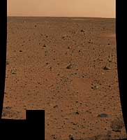 First Color Image from Spirit
This is the first color image of Mars taken by the panoramic camera on the
Mars Exploration Rover Spirit. It is the highest resolution image ever
taken on the surface of another planet.
(Courtesy NASA/JPL)
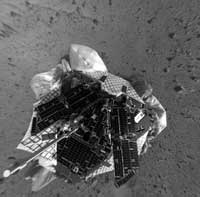 View From Above Spirit on Mars-2
This mosaic image taken by the navigation camera on the Mars Exploration Rover Spirit has been
reprocessed to project a clear overhead view of the rover on the surface of Mars.
(Courtesy NASA/JPL)
 First Look at Spirit on Mars-2
This mosaic image taken by the navigation camera on the Mars Exploration Rover Spirit
has been further processed, resulting in a significantly improved 360 degree panoramic
view of the rover on the surface of Mars.
(Courtesy NASA/JPL)
|


