Where there is no vision, the people perish.
- Proverbs 29:18
|
Table of Contents |
|
Mars Introduction
|
|
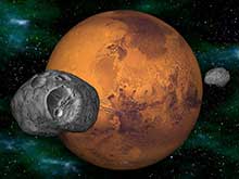
Moons of Mars |
|
Deimos,
Phobos |
|
Mars Science |
|
Historical Books |
|
|
|
Mars Resources |
Before space exploration, Mars was considered the best candidate for harboring extraterrestrial life. Astronomers thought they saw straight lines crisscrossing its surface. This led to the popular belief that irrigation canals on the planet had been constructed by intelligent beings. In 1938, when Orson Welles broadcasted a radio drama based on the science fiction classic War of the Worlds by H.G. Wells, enough people believed in the tale of invading Martians to cause a near panic.
Another reason for scientists to expect life on Mars had to do with the apparent seasonal color changes on the planet's surface. This phenomenon led to speculation that conditions might support a bloom of Martian vegetation during the warmer months and cause plant life to become dormant during colder periods.
In July of 1965, Mariner 4, transmitted 22 close-up pictures of Mars. All that was revealed was a surface containing many craters and naturally occurring channels but no evidence of artificial canals or flowing water. Finally, in July and September 1976, Viking Landers 1 and 2 touched down on the surface of Mars. The three biology experiments aboard the landers discovered unexpected and enigmatic chemical activity in the Martian soil, but provided no clear evidence for the presence of living microorganisms in the soil near the landing sites. According to mission biologists, Mars is self-sterilizing. They believe the combination of solar ultraviolet radiation that saturates the surface, the extreme dryness of the soil and the oxidizing nature of the soil chemistry prevent the formation of living organisms in the Martian soil. The question of life on Mars at some time in the distant past remains open.
Other instruments found no sign of organic chemistry at either landing site, but they did provide a precise and definitive analysis of the composition of the Martian atmosphere and found previously undetected trace elements.
Atmosphere
The atmosphere of Mars is quite different from that of Earth. It is composed primarily of carbon dioxide with small amounts of other gases. The six most common components of the atmosphere are:
- Carbon Dioxide (CO2): 95.32%
- Nitrogen (N2): 2.7%
- Argon (Ar): 1.6%
- Oxygen (O2): 0.13%
- Water (H2O): 0.03%
- Neon (Ne): 0.00025 %
Martian air contains only about 1/1,000 as much water as our air, but even this small amount can condense out, forming clouds that ride high in the atmosphere or swirl around the slopes of towering volcanoes. Local patches of early morning fog can form in valleys. At the Viking Lander 2 site, a thin layer of water frost covered the ground each winter.
There is evidence that in the past a denser martian atmosphere may have allowed water to flow on the planet. Physical features closely resembling shorelines, gorges, riverbeds and islands suggest that great rivers once marked the planet.
Temperature and Pressure
The average recorded temperature on Mars is -63° C (-81° F) with a maximum temperature of 20° C (68° F) and a minimum of -140° C (-220° F).
Barometric pressure varies at each landing site on a semiannual basis. Carbon dioxide, the major constituent of the atmosphere, freezes out to form an immense polar cap, alternately at each pole. The carbon dioxide forms a great cover of snow and then evaporates again with the coming of spring in each hemisphere. When the southern cap was largest, the mean daily pressure observed by Viking Lander 1 was as low as 6.8 millibars; at other times of the year it was as high as 9.0 millibars. The pressures at the Viking Lander 2 site were 7.3 and 10.8 millibars. In comparison, the average pressure of the Earth is 1000 millibars.
| Mars Statistics | |
|---|---|
| Mass (kg) | 6.421e+23 |
| Mass (Earth = 1) | 1.0745e-01 |
| Equatorial radius (km) | 3,397.2 |
| Equatorial radius (Earth = 1) | 5.3264e-01 |
| Mean density (gm/cm^3) | 3.94 |
| Mean distance from the Sun (km) | 227,940,000 |
| Mean distance from the Sun (Earth = 1) | 1.5237 |
| Rotational period (hours) | 24.6229 |
| Rotational period (days) | 1.025957 |
| Orbital period (days) | 686.98 |
| Mean orbital velocity (km/sec) | 24.13 |
| Orbital eccentricity | 0.0934 |
| Tilt of axis (degrees) | 25.19 |
| Orbital inclination (degrees) | 1.850 |
| Equatorial surface gravity (m/sec^2) | 3.72 |
| Equatorial escape velocity (km/sec) | 5.02 |
| Visual geometric albedo | 0.15 |
| Magnitude (Vo) | -2.01 |
| Minimum surface temperature | -140°C |
| Mean surface temperature | -63°C |
| Maximum surface temperature | 20°C |
| Atmospheric pressure (bars) | 0.007 |
| Atmospheric composition
Carbon Dioxide (C02)
Nitrogen (N2) Argon (Ar) Oxygen (O2) Carbon Monoxide (CO) Water (H2O) Neon (Ne) Krypton (Kr) Xenon (Xe) Ozone (O3) | 95.32% 2.7% 1.6% 0.13% 0.07% 0.03% 0.00025% 0.00003% 0.000008% 0.000003% |
- Rotating Mars Movie.
- Mars Topography Movie.
- Animation of Tharsis Tholus.
- Animation of the Olympus Mons Caldera.
- Mars Global Surveyor Animation.
- Mars the Movie.
- Flight over Valles Marineris.
- Animation of Martian Poles.
- Animation over Olympus Mons.
- Hubble Telescope full-globe animation.
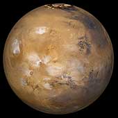 Mars With Cloud Cover
This image of mars came from a series of pictures taken by the Mars
Global Surveyor wide angle cameras. A map was created and then wrapped
around a sphere to generate this view of Mars. Here, bluish-white water
ice clouds hang above the Tharsis volcanoes.
(Copyright 2005 by Calvin J. Hamilton)
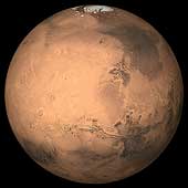 Large Mosaic of Mars
This image is a large mosaic of the Valles Marineris [VAL-less mar-uh-NAIR-iss]
hemisphere of Mars. It is a view similar to that which one would see
from a spacecraft. The lower center of the scene shows the entire Valles
Marineris canyon system, more than 3,000 kilometers (1,860 miles) long
and up to 8 kilometers (5 miles) deep, extending from Noctis
Labyrinthus, the arcuate system of graben to the west, to the chaotic
terrain to the east. Many huge ancient river channels begin from the
chaotic terrain and north-central canyons and run north. Many of the
channels flowed into a basin called Acidalia Planitia, which is the dark
area in the extreme north of this picture. The three Tharsis volcanoes
(dark red spots), each about 25 kilometers (16 miles) high, are visible
to the west along with Olympus Mons the largest volcano on the planet.
Very ancient terrain covered by many impact craters lies to
the south of Valles Marineris. The polar cap can be seen to the north.
(Copyright Calvin J. Hamilton)
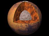 The Interior of Mars
The current understanding of the interior of Mars suggests that it
can be modeled with a thin crust, similar to Earth's, a mantle and a core.
Using four parameters, the Martian core size and mass can be determined.
However, only three out of the four are known and include the total mass,
size of Mars, and the moment of inertia. Mass and size was determined accurately
from early missions. The moment of inertia was determined from
Viking lander and Pathfinder Doppler data, by measuring the
precession rate of Mars. The fourth parameter, needed to complete the
interior model, will be obtained from future spacecraft missions.
With the three known parameters, the model is significantly
constrained. If the Martian core is dense (composed of iron) similar
to Earth's or SNC meteorites thought to originate from Mars, then
the minimum core radius would be about 1300 kilometers. If the
core is made out of less-dense material such as a mixture of sulfur
and iron, the maximum radius would probably be less than 2000 kilometers.
(Copyright 1998 by Calvin J. Hamilton)
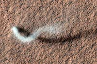 The Serpent Dust Devil of Mars
A towering dust devil, casts a serpentine shadow over the Martian surface in this image acquired by the High Resolution Imaging Science Experiment (HiRISE) camera on NASA's Mars Reconnaissance Orbiter.
The scene is a late-spring afternoon in the Amazonis Planitia region of northern Mars. The view covers an area about four-tenths of a mile (644 meters) across. North is toward the top. The length of the dusty whirlwind's shadow indicates that the dust plume reaches more than half a mile (800 meters) in height. The plume is about 30 yards or meters in diameter.
A westerly breeze partway up the height of the dust devil produced a delicate arc in the plume. The image was taken during the time of Martian year when the planet is farthest from the sun. Just as on Earth, winds on Mars are powered by solar heating. Exposure to the sun's rays declines during this season, yet even now, dust devils act relentlessly to clean the surface of freshly deposited dust, a little at a time.
(Courtesy NASA/JPL-Caltech/Univ. of Arizona)
 Topography Map of Mars
This image is a newly released topographic map of Mars.
The full range of topography on Mars is about 19 miles
(30 kilometers), one and a half times the range of elevations
found on Earth, The most curious aspect of the map is the
striking difference between the planet's low, smooth Northern
Hemisphere and the heavily cratered Southern Hemisphere,"
which sits, on average, about three miles (five kilometers)
higher than the north.
(Courtesy GSFC/NASA)
 Schiaparelli Hemisphere
This image is a mosaic of the Schiaparelli hemisphere of
Mars. The center of this image is near
the impact crater Schiaparelli, 450 kilometers
(280 miles) in diameter.
The dark streaks with bright margins emanating from craters in
the Oxie Palus region, upper left of image, are caused by erosion
and/or deposition by the wind. Bright white areas to the south,
including the Hellas impact basin at extreme lower right, are
covered by carbon dioxide frost. (Courtesy USGS)
 Central Candor Chasm - Oblique View
This image shows part of Candor Chasm in Valles Marineris.
It is centered at Latitude -5.0, Longitude 70.0. The view
is from the north looking into the chasm. Candor Chasm's geomorphology
is complex, shaped by tectonics, mass wasting, wind, and perhaps by
water and volcanism.
(Courtesy USGS)
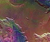 West Candor Chasm (Enhanced Color)
This picture (centered at latitude 4° S, longitude 76° W) shows areas of
central Valles Marineris, including Candor Chasm (lower left), Ophir Chasm
(lower right), and Hebes Chasm (upper right). Complex layered deposits in the
canyons may have been deposited in lakes, and if so, are of great interest for
future searches for fossil life on Mars. The pinkish deposits in Candor Chasm
may be due to hydrothermal alterations and the production of crystalline ferric
oxides. ((Geissler et al., 1993, Icarus 106,380). Viking Orbiter Picture
Numbers 279B02 (violet), 279B10 (green), and 279B12 (red) at 240 meters/pixel
resolution. Picture width is 231 kilometers. North is 47° clockwise from
top.)
 Ophir Chasma
Ophir Chasma is a large west-northwest-trending trough about 100 km
wide. The Chasma is bordered by 4 km high walled cliffs, most
likely faults, that show spur-and-gully morphology and smooth sections.
The walls have been dissected by landslides forming reentrants;
one area (upper left) on the north wall shows a young landslide about
100 km wide. The volume of the landslide debris is more than
1000 times greater than that from the May 18, 1980 debris avalanche
from Mount St. Helens. The longitudinal grooves seen in the
foreground are thought to be due to differential shear and lateral
spreading at high velocities. The landslide passes between mounds of
interior layered deposits on the floor of the chasma.
(Courtesy USGS)
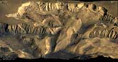
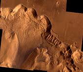
 Landslide in Valles Marineris
Although Valles Marineris originated as a tectonic structure, it has
been modified by other processes. This image shows a close-up view of
a landslide on the south wall of Valles Marineris. This landslide
partially removed the rim of the crater that is on the plateau adjacent
to Valles Marineris. Note the texture of the landslide deposit where it
flowed across the floor of Valles Marineris. Several distinct layers
can be seen in the walls of the trough. These layers may be regions of
distinct chemical composition or mechanical properties in the Martian
crust.
(Copyright Calvin J. Hamilton; Caption: LPI)
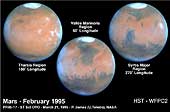 HST 3 Views of Mars at Opposition
These Hubble Space Telescope views provide the most detailed complete
global coverage of the Red Planet ever seen from Earth. The pictures
were taken on February 25, 1995, when Mars was at a distance of 103
million kilometers (65 million miles). To the surprise of researchers,
Mars is cloudier than seen in previous years. This means the planet is
cooler and drier, because water vapor in the atmosphere freezes out to
form ice-crystal clouds. The three images show the Tharsis, Valles
Marineris and Syrtis Major regions.
(Credit: Philip James, University of Toledo; Steven Lee, University
of Colorado; and NASA)
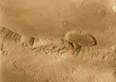
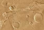 Outflow Source of Channel Ravi Vallis
This image of the head of Ravi Vallis shows a 300-kilometer (186-mile)
long portion of a channel. Like many other channels that empty into
the northern plains of Mars, Ravi Vallis orginates in a region of
collapsed and disrupted ("chaotic") terrain within the planet's older,
cratered highlands. Structures in these channels indicate that they
were carved by liquid water moving at high flow rates. The abrupt
beginning of the channel, with no apparent tributaries, suggests that
the water was released under great pressure from beneath a confining
layer of frozen ground. As this water was released and flowed away, the
overlying surface collapsed, producing the disruption and subsidence
shown here. Three such regions of chaotic collapsed material are seen in
this image, connected by a channel whose floor was scoured by the flowing
water. The flow in this channel was from west to east (left to right).
This channel ultimately links up with a system of channels that flowed
northward into Chryse Basin.
(Copyright Calvin J. Hamilton; Caption: LPI)
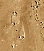 Streamlined Islands
The water that carved the channels to the north and east of the Valles
Marineris canyon system had tremendous erosive power. One consequence
of this erosion was the formation of streamlined islands where the water
encountered obstacles along its path. This image shows two streamlined
islands that formed as the water was diverted by two 8-10 kilometer
(5-6 mile) diameter craters lying near the mouth of Ares Vallis in Chryse
Planitia. The water flowed from south to north (bottom to top of the
image). The height of the scarp surrounding the upper island is about 400
meters (1,300 feet), while the scarp surrounding the southern island is
about 600 meters (2,000 feet) high.
(Copyright Calvin J. Hamilton; Caption: LPI)
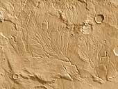 Valley Network
Unlike the features shown in the above two images, many systems on Mars
do not show evidence of catastrophic flooding. Instead, they show a
resemblance to drainage systems on Earth, where water acts at
slow rates over long periods of time. As on Earth, the channels shown
here merge together to form larger channels.
However, these valley networks are less developed than typical terrestrial
drainage systems, with the Martian examples lacking small-scale streams
feeding into the larger valleys. Because of the absence of small-scale
streams in the Martian valley networks, it is thought that the valleys
were carved primarily by ground water flow rather than by runoff of
rain. Although liquid water is currently unstable on the surface of
Mars, theoretical studies indicate that flowing groundwater might be
able to form valley networks if the water flowed beneath a protective
cover of ice. Alternatively, because the valley networks are confined
to relatively old regions of Mars, their presence may indicate that Mars
once possessed a warmer and wetter climate in its early history.
(Copyright Calvin J. Hamilton; Caption: LPI)
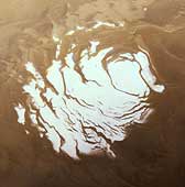 South Polar Cap
This image shows the south polar cap of Mars as it appears near
its minimum size of about 400 kilometers (249 miles). It consists
mainly of frozen carbon dioxide. This carbon dioxide cap never melts
completely. The ice appears reddish due to dust that has been
incorporated into the cap. (Courtesy NASA)
 North Polar Cap
This image is an oblique view of the north polar cap of Mars.
Unlike the south polar cap, the north polar cap probably consists
of water-ice.
(Copyright Calvin J. Hamilton)
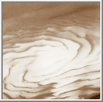
 Polar Laminated Terrain
One of the discoveries of the Mariner 9 spacecraft was that the south polar
cap of Mars was made of thin layers or laminations of ice and sediment. Four
years later, on October 10, 1976, the Viking 2 spacecraft took this picture
of the Martian north polar cap. The visible layering occurred as a result of
wind born dust settling upon the polar cap. As the caps experience climatic
variations, they expand and contract. The layers of dust sediment tend to
grow thicker near the poles where ice deposits remain for longer periods of
time. The thickness of the deposits indicates they were formed during
cyclical climatic variation rather than annual changes. As ice withdraws
from a region, wind exposes the layers sculpting valleys and scarps.
The formation of layered deposits is an active process today.
(Copyright 1998 by Calvin J. Hamilton)
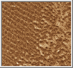 Dunefield
This image shows several dune types which are found in the north
circumpolar dunefield. This thumnail image shows a section of transverse
dunes. The full image has a field of traverse dunes on the left and
barchan dunes on the right with a transition zone inbetween. Transverse
dunes are oriented perpendicular to the prevailing wind direction. They
are long and linear, and frequently join their neighbor in a low-angle
"Y" junction. Barchan dunes are crescent-shaped mounds with
downwind-pointing horns. These dunes are comparable in size to the
largest dunes found on the Earth.
(Copyright Calvin J. Hamilton)
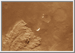 Local Dust Storm
Local dust storms are relatively common on Mars. They tend to occur in
areas of high topographic and/or high thermal gradients (usually near the
polar caps), where surface winds would be strongest. This storm is
several hundreds of kilometers in extent and is located near the edge
of the south polar cap. Some local storms grow larger, others die out.
(Copyright Calvin J. Hamilton; caption by LPI)
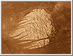 White Rock
This image shows a lesser known, but unusual feature on Mars.
It is commonly called "White Rock". The white feature is eroded
crater fill, but exactly how it was formed has not been
satisfactorily explained. White Rock was not formed by polar
processes because it lies near to the equator at
latitude -8 degrees and longitude 355 degrees. It has been
modified through aeolian erosion showing transverse and
longitudinal erosional features.
(Copyright 1998 by Calvin J. Hamilton)
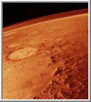 Martian Atmosphere
This oblique image taken by the Viking orbiter spacecraft
shows a thin band of the Martian atmosphere. This image looks
northeast across the Argyre basin. The Argyre basin is about 600
kilometers across with a rugged rim of about 500 kilometers
in width.
(Copyright 1997 by Calvin J. Hamilton)
The following table summarizes the radius, mass, distance from the planet center, discoverer and the date of discovery of each of the moons of Mars:
| Moon | # | Radius (km) | Mass (kg) | Distance (km) | Discoverer | Date |
|---|---|---|---|---|---|---|
| Phobos | I | 13.5x10.8x9.4 | 1.08e+16 | 9,380 | A. Hall | 1877 |
| Deimos | II | 7.5x6.1x5.5 | 1.80e+15 | 23,460 | A. Hall | 1877 |
Beatty, J. K. and A. Chaikin, eds. The New Solar System. Massachusetts: Sky Publishing, 3rd Edition, 1990.
Carr M. H. The Surface of Mars. Yale University Press, New Haven, 1981.
Kiefer, Walter S., Allan H. Treiman, and Stephen M. Clifford. The Red Planet: A Survey of Mars - Slide Set. Lunar and Planetary Institute.
Mutch T. A., Arvidson R. E., Head J. W. III, Jones K. L., and Saunders R. S. The Geology of Mars. Princeton University Press, Princeton, 1976.
Williams, Steven H. The Winds of Mars: Aeolian Activity and Landforms - Slide Set. Lunar and Planetary Institute.

 Return to Earth
 Voyage to Jupiter