|
Table of Contents |
|
Hawaiian Volcanoes
|
|
Earth's Volcanoes |
|
Volcanoes on Other Worlds |
|
More Information |
After volcanic mountains reach the surface, they are subject to the effects of erosion; unless lava continues to flow, the whole mass could wear away. In the early stages of erosion, a fringing reef will attach to the shore, such as occurred off Waikiki Beach in Honolulu. A fringing reef will eventually become separated from the shore by a lagoon, forming a barrier reef. Eventually erosion or submergence might completely overcome the island and the barrier reef might form an atoll, which is a ring-shaped coral island forming a lagoon. When the top is completely worn away, it leaves a shoal cutting across the volcanic cone several fathoms below sea level, similar to the French Frigate Shoal.
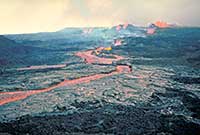
Eruptions in the Hawaiian volcanoes are usually preceded by a series of earthquakes which open fissures and allow magma to reach the surface. Initially lava fountains, known as "curtains of fire," hurl streams of lava hundreds of feet into the air from many points along the fissure. Hawaiian flows are considered to issue forth relatively quietly since the lava is quite fluid, and the gases escape readily without the disruption of the lava into ash or cinders. Great floods of lava will then flow down the mountainside. Eruptions have lasted from a few days to ten months, frequently followed in two or three years by a flank eruption.
Mauna Loa is considered the "monarch of mountains." It is the largest volcano and the largest single mountain of any kind in the world. It is 97 kilometers (60 miles) long, 48 kilometers (30 miles) wide, and rises about 8,742 meters (28,680 feet) from its base on the sea floor. The slopes of Mauna Loa are no steeper than 12°, with a mere 4° slope near the top. On the summit is an oval shaped caldera called Mokuaweoweo which is 4.8 kilometers (3 miles) long, 2.4 kilometers (1.5 miles) wide, and 183 meters (600 feet) deep. Eruptions usually begin as lava fountains on the floor of Mokuaweoweo and are followed by great volumes of lava, although sometimes eruptions flow without the initial outbreak. Mauna Loa is extremely prolific producing .9 to 4.5 million metric tons (1 to 5 million tons) of lava per hour in the early stages of an eruption. In 1831, three-fifths of a cubic mile was added to its mass. During the period between 1831 to 1950, Mauna Loa averaged an eruption every 3.6 years and was active nearly 6.2% of the time [Press, 1986].
The Kilauea Volcano is located about 3,048 meters (10,000 feet) below the summit of Mauna Loa. It is a shield volcano approximately 80 kilometers (50 miles) long and 22.5 kilometers (14 miles) wide that accumulated along the side of Mauna Loa. The summit of Kilauea is 1,250 meters (4,090 feet) above sea level, 6,096 meters (20,000 feet) above the ocean floor. The summit caldera is 4 kilometers (2.5 miles) long, 3.2 kilometers (2 miles) wide, and about 120 meters (400) feet deep. Near the southwestern edge of the caldera is the "fire pit," known as Halemaumau (House of Everlasting Fire), which has at times contained a lake of boiling lava. The pit is enlarged periodically by steam blasts and collapsing walls. In 1924, it was enlarged from 610 to 1,070 meters (2,000 to 3,500 feet) in diameter and measured 396 meters (1,300 feet) deep. Typical eruptions consist of lava flows forming lava lakes in Halemaumau or elsewhere on the caldera through fissures and rift zones. However, Halemaumau seems to be the principle conduit where lava reaches the surface.
The unifying agent among volcanoes is the active ingredient of gas. The primary gas given off in an eruption is water vapor or steam. When water changes from a liquid state to a solid state, the expansion is about one ninth of its volume. When water changes from a liquid state to a gaseous state its volume increases 1,000 times; thus producing the force necessary for a volcanic eruption. Before eruption, water and dissolved gases are confined by the pressure of the overlying rocks, but as the magma rises to the surface the pressure drops and the gases are released. Gas is necessary to move the magma, and magma is the vehicle carrying the gas.
As magma is released from the vent, lava flows along Earth's surface and eventually takes one of two contrasting but related forms which Hawaiians have named aa and pahoehoe (pronounced ah ah and pahoyhoy). Pahoehoe is formed as a layer of "skin" covers the underlying liquid lava and the movement of the continued lava flow below begins to wrinkle the surface creating a ropy or billowy appearance. Pahoehoe in Hawaiian means "ropy." Aa is what a barefoot Hawaiian would say while walking on it: "ah . . . ah . . . oh . . . ah" [Press, 1986]. Its sharp, angular, jagged blocks have dangerously sharp edges and spiny projections on a noncontinuous surface. Some flows issue from the vent as pahoehoe and change to aa as they are stirred, cooled, lose gas, and increase in crystallization. Lava does not convert from aa to pahoehoe. Once a crust has formed on pahoehoe, lava tubes below continue to move the remaining liquid for long periods of time. The size of the tubes range from only a few inches to many feet in diameter. When the source of lava stops, the liquid continues to drain, leaving lava tubes or caves. Spatter cones are steep sided, conical hills built from the spatter of lava fountains. Underwater flows produce pillow lava which are ellipsoidal, sacklike blocks about a meter in dimension budding off of lava tongues or tubes. Lavas can have many features depending on the rate in which they cool.
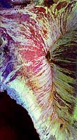
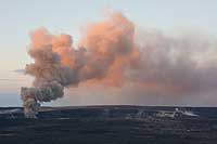 Halema`uma`u, Kilauea Volcano
What began as a new gas vent (fumarole) in Halema`uma`u crater sometime
between March 10 and 12, 2008, progressed to be the first explosive eruption
in Halema`uma`u Crater since 1924 and the first lava erupted from the crate
r since 1982. During the early moring hours of March 26, 2008 we photographed
the volcanoe spewing out large amounts of ash.
(Copyright Rosanna Hamilton)
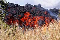
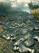
 A`a and Pahoehoe Lava Flows
The foreground shows a good example of an A`a lava flow on the top of an
existing Pahoehoe lava flow (visible in the background). This picture was
take on March 26, 2008 at Hawaii Volcanoes National Park.
(Copyright Rosanna Hamilton)
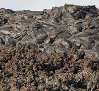
 A'a Lava Flow, Hawaii
A'a lava flows are typically blocky, usually approximately 3-20 meters
(10 to 66 feet)
thick, and rolls over itself across the ground like a tank track. The
jagged flow front normally creeps forward and steepens until a section
becomes unstable and breaks off, revealing the incandescent central core.
This picture was taken on January 29, 2008 in the Royal Gardens subdivision.
(Courtesy of USGS)
 Pahoehoe Lava Flow, Kilauea Volcano Hawaii
Pahoehoe is a Hawaiian term for basaltic lava that has a smooth,
hummocky, or ropy surface. A pahoehoe flow typically advances as a
series of small lobes and toes that continually break out from a cooled
crust. The surface texture of pahoehoe flows varies widely, displaying
all kinds of bizarre shapes often referred to as lava sculpture.
Pahoehoe flows are much thinner than a'a flows, sometimes being only
30-50 centimeters (12 -20 inches) thick.
(Courtesy of J.D. Griggs, USGS)
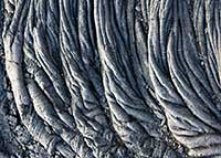 Pahoehoe Lava Flow, Hawaii
This images shows the classic "ropy" texture of a pahoehoe lava flow.
(Copyright Calvin J. Hamilton)
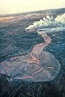
'A'a Lava Channel, Hawaii
Lava pours down a well-developed lava channel near a series of erupting vents on the northeast rift
zone of Mauna Loa Volcano. The eruption started from fissures in the volcano's summit caldera on
March 25 and migrated to these vents on March 26. This lava channel fed an `a`a flow that
traveled 25 kilometers until lava broke from the channel to feed another flow on March 29. The channel
width varied 20 to 50 meters and extended to within 1 to 2 kilometers of the flow front.
Channelized flows can also be found within lunar,
Martian, and Venusian lava flows and are
thought to be an indicator of high discharge rates.
(Courtesy J.D. Griggs, USGS)
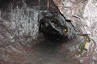 Thurston Lava Tube, Hawaii
In Hawaii, many lava flows form tubes that may extend for several
kilometers. This is an efficient way for the lava to travel
comparatively large distances without significant cooling. Thurston Lava
Tube, located close to the summit of Kilauea Caldera, is a fine example
of this type of landform. Here the tube is approximately 3 meters
(10 feet) in diameter. Note two lava benches on the wall on the left.
(Photo Copyright Calvin J. Hamilton; Caption courtesy of P. Mouginis-Mark, LPI)
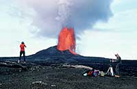 Fire Fountain Eruption, Pu'u O'o, Hawaii
Scientists studied fire fountains from the phase 34 eruption (August 1984)
of Pu'u O'o in Hawaii to investigate the dispersal and cooling of ejected
materials. In this view, the incandescent part of the plume is
approximately 200 meters (660 feet) high. Large
clasts from this fire fountain retained
their heat to such an extent that they coalesced on the ground to form
a lava flow that moved away from the vent (at right in this view).
Pu'u O'o is located about 15 kilometers (9.3 miles) down
rift from the summit of Kilauea Caldera,
on the East Rift Zone.
(Courtesy of P. Mouginis-Mark, LPI)
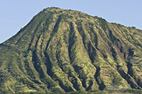 Channels on Koko Crater, Oahu, Hawaii
The flanks of Koko Crater on the island of Oahu, Hawaii, show signs of
extensive gully erosion. Koko Crater is approximately 400 meters
(1,320 feet) high. Here we see valleys 3-5 meters (10-16 feet)
deep that have been caused primarily by surface water flow and,
close to the summit, by sapping.
Although spaced further apart on
Martian volcanoes such as
Tyrrhena Patera, similar valleys
might have formed on the older volcanoes on Mars
as water from the original explosive eruptions was released at the
surface. Note, however, that the valleys on Tyrrhena Patera
might be 3-5 kilometers (1.9-3 miles) wide, which is wider than the
entire Koko Crater cone.
(Photo Copyright Calvin J. Hamilton; Caption courtesy of P. Mouginis-Mark, LPI)
 Kupaianaha Lava Lake, Hawaii
Lava lakes are large volumes of molten lava, usually basaltic, contained
in a vent, crater, or broad depression. Scientists use the term to describe
both lava lakes that are molten and those that are partly or completely
solidified. Lava lakes can form (1) from one or more vents in a crater that
erupts enough lava to partially fill the crater; (2) when lava pours into
a crater or broad depression and partially fills the crater; and (3) atop
a new vent that erupts lava continuously for a period of several weeks or
more and slowly builds a crater higher and higher above the surrounding ground.
This image of the Kupaianaha lava pond was taken in December
1986. Cracks zigzag across the thin crust
on the pond revealing the molten rock below. The entrance to the lava tube that
carried lava toward the sea is at the end of the long neck on the pond.
The circular part of the pond is about 100 meters in diameter.
(E. Wolfe, USGS)
 Kupaianah Lava Lake, Hawaii
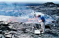
Using a spectroradiometer,
scientists were able to measure the radiative temperature and thermal output
from the Kupaianaha Lava Lake. This instrument collects spectra from 0.4-3.0
micrometers in over 800 channels, thereby permitting an accurate
determination of the blackbody temperature
of the surface. Such studies are of value because they show that the surface of a lava lake (or a lava flow) is remarkably cool - perhaps only a few
hundred degrees centigrade - compared to the eruptive temperature of
approximately 1,150°C (2,102°F).
Such temperatures are quite similar to those the
Voyager 1 spacecraft measured for the volcanic activity on
Io, suggesting that silicate lavas, as opposed to
molten sulfer, could exist within lava lakes on Io.
(Courtesy of P. Mouginis-Mark, LPI)
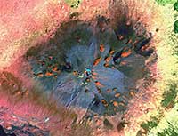
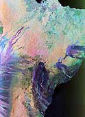 Kilauea Volcano, Hawaii
This is a color composite radar image of the Kilauea volcano on the
Big Island of Hawaii. The city of Hilo can
be seen at the top. The image shows the different types of lava
flows around the crater Pu'u O'o. Ash deposits which erupted in
1790 from the summit of Kilauea volcano show up as dark in this
image, and fine details associated with lava flows which erupted
in 1919 and 1974 can be seen to the south of the summit in an
area called the Ka'u Desert. In addition, the other historic
lava flows created in 1881 and 1984 from Mauna Loa volcano (out
of view to the left of this image) can be easily seen despite the
fact that the surrounding area is covered by forest. The
Kilauea volcano has been almost continuously active for more than
the last 11 years. A moving lava flow about 200 meters
(660 feet) in length was observed at the time of the shuttle
overflight.
(Courtesy NASA/JPL)
 Mauna Loa Volcano, Hawaii
This image of the Mauna Loa volcano on the Big Island of
Hawaii shows the capability of imaging radar to map lava
flows and other volcanic structures. Mauna Loa has erupted
more than 35 times since the island was first visited by
westerners in the early 1800s. The large summit crater,
called Mokuaweoweo Caldera, is clearly visible near the
center of the image. Leading away from the caldera (towards
top right and lower center) are the two main rift zones
shown here in orange. Rift zones are areas of weakness
within the upper part of the volcano that are often ripped
open as new magma (molten rock) approaches the surface at
the start of an eruption. The most recent eruption of Mauna
Loa was in March and April 1984, when segments of the
northeast rift zones were active. If the height of the
volcano was measured from its base on the ocean floor
instead of from sea level, Mauna Loa would be the tallest
mountain on Earth. Its peak (center of the image) rises
more than 8 kilometers (5 miles) above the ocean floor. The
South Kona District, known for cultivation of macadamia nuts
and coffee, can be seen in the lower left as white and blue
areas along the coast. North is toward the upper left. The
area shown is 41.5 by 75 kilometers (25.7 by 46.5 miles),
centered at 19.5 degrees north latitude and 155.6 degrees
west longitude.
The different color combinations in
this radar image are caused by differences in surface
roughness of the lava flows. Smoother pahoehoe flows
are depicted in red, and rougher a'a flows
are shown in yellow and white.
(Courtesy NASA/JPL)
 Mauna Kea Summit, Hawaii
This is a false-color composite image of Mauna Kea Summit, Hawaii. It was
constructed from data gathered between 1999 and 2001 by the Enhanced Thematic Mapper
plus (ETM+) instrument, flying aboard the Landsat 7 satellite.
Hawaii was created by a "hotspot" beneath the ocean floor. Hotspots form in areas where superheated magma in the Earth's mantle breaks through the Earth's crust. Over the course of millions of years, the Pacific Tectonic Plate has slowly moved over this hotspot to form the entire Hawaiian Island archipelago.
Mauna Kea Volcano is dormant and hasn't erupted in an estimated 3,500 years.
The red areas show iron oxide deposits in the cinder cones. Blue areas show debris
generated during the last ice age.
(Courtesy NASA)
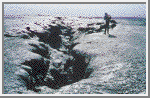 Vent Area, Kilauea, Hawaii
The December 1974 lava flow erupted from a series of
en echelon fissures close to the summit
of Kilauea Caldera. Here is an example of a fissure approximately 2 meters
(6.6 feet) wide.
Fissures of comparable dimensions may also have been the vents for
the flows on the flanks of Sif Mons, Venus.
(Courtesy of L. Gaddis and LPI)
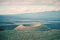 Pu`u ka Pele Cinder Cone, Mauna Kea Volcano
A cinder cone is a steep, conical hill of volcanic fragments that accumulate
around and downwind from a vent. The rock fragments, often called cinders or
scoria, are glassy and contain numerous gas bubbles "frozen" into place as magma
exploded into the air and then cooled quickly. Cinder cones range in size from
tens to hundreds of meters tall.
This cinder cone (Pu`u ka Pele) was erupted low on the
southeast flank of Mauna Kea Volcano. The cone is 95 meters
in height with a crater diameter of 400 meters at the top.
Hualalai Volcano is in the background.
(Courtesy of USGS/J.P. Lockwood)
Many of the images and captions were taken from the Mouginis-Mark slide set.
Bullard, Fred M. Volcanoes. University of Texas Press Austin & London, 1976.
Press, Frank and Raymond Siever. Earth. W. H. Freeman and Company, New York, 4th edition, 1986.
Mouginis-Mark, Peter. Volcanic Features of Hawaii and Other Worlds. Lunar and Planetary Institute, slide set.

 Terrestrial Volcanoes