|
COMETS EARTH JUPITER KUIPER BELT MARS MERCURY METEORITES NEPTUNE OORT CLOUD PLUTO SATURN SOLAR SYSTEM SPACE SUN URANUS VENUS ORDER PRINTS
PHOTO CATEGORIES SCIENCEVIEWS AMERICAN INDIAN AMPHIBIANS BIRDS BUGS FINE ART FOSSILS THE ISLANDS HISTORICAL PHOTOS MAMMALS OTHER PARKS PLANTS RELIGIOUS REPTILES SCIENCEVIEWS PRINTS
|
Related Documents
Download Options
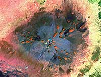
This is a false-color composite image of Mauna Kea Summit, Hawaii. It was constructed from data gathered between 1999 and 2001 by the Enhanced Thematic Mapper plus (ETM+) instrument, flying aboard the Landsat 7 satellite. Hawaii was created by a "hotspot" beneath the ocean floor. Hotspots form in areas where superheated magma in the Earth’s mantle breaks through the Earth’s crust. Over the course of millions of years, the Pacific Tectonic Plate has slowly moved over this hotspot to form the entire Hawaiian Island archipelago. Mauna Kea Volcano is dormant and hasn’t erupted in an estimated 3,500 years. The red areas show iron oxide deposits within the cinder cones. Blue areas show debris generated during the last ice age. |