|
COMETS EARTH JUPITER KUIPER BELT MARS MERCURY METEORITES NEPTUNE OORT CLOUD PLUTO SATURN SOLAR SYSTEM SPACE SUN URANUS VENUS ORDER PRINTS
PHOTO CATEGORIES SCIENCEVIEWS AMERICAN INDIAN AMPHIBIANS BIRDS BUGS FINE ART FOSSILS THE ISLANDS HISTORICAL PHOTOS MAMMALS OTHER PARKS PLANTS RELIGIOUS REPTILES SCIENCEVIEWS PRINTS
|
Related Documents
Download Options
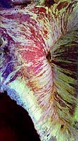
This image of the Mauna Loa volcano on the Big Island of Hawaii shows the capability of imaging radar to map lava flows and other volcanic structures. Mauna Loa has erupted more than 35 times since the island was first visited by westerners in the early 1800s. The large summit crater, called Mokuaweoweo Caldera, is clearly visible near the center of the image. Leading away from the caldera (towards top right and lower center) are the two main rift zones shown here in orange. Rift zones are areas of weakness within the upper part of the volcano that are often ripped open as new magma (molten rock) approaches the surface at the start of an eruption. The most recent eruption of Mauna Loa was in March and April 1984, when segments of the northeast rift zones were active. If the height of the volcano was measured from its base on the ocean floor instead of from sea level, Mauna Loa would be the tallest mountain on Earth. Its peak (center of the image) rises more than 8 kilometers (5 miles) above the ocean floor. The South Kona District, known for cultivation of macadamia nuts and coffee, can be seen in the lower left as white and blue areas along the coast. North is toward the upper left. The area shown is 41.5 by 75 kilometers (25.7 by 46.5 miles), centered at 19.5 degrees north latitude and 155.6 degrees west longitude. The image was acquired by the Spaceborne Imaging Radar-C/X-Band Synthetic Aperture Radar (SIR-C/ X-SAR) aboard the space shuttle Endeavour on its 36th orbit on October 2, 1994. The radar illumination is from the left of the image. The colors in this image were obtained using the following radar channels: red represents the L-band (horizontally transmitted and received); green represents the L-band (horizontally transmitted, vertically received); blue represents the C-band (horizontally transmitted, vertically received). The resulting color combinations in this radar image are caused by differences in surface roughness of the lava flows. Smoother flows, called pahoehoe flows, are depicted in red, and rougher flows, called a'a flows in volcanology terminology that originated in the Hawaiian language, are shown in yellow and white. Mauna Loa is one of 15 volcanoes worldwide that are being monitored by the scientific community as an "International Decade Volcano" because of the hazard that it represents to the local towns of Hilo and Kona. The Kilauea volcano is located off to the right of Mauna Loa and is not visible in this image. Spaceborne Imaging Radar-C and X-band Synthetic Aperture Radar (SIR-C/X-SAR) is part of NASA's Mission to Planet Earth. The radars illuminate Earth with microwaves allowing detailed observations at any time, regardless of weather or sunlight conditions. SIR-C/X-SAR uses three microwave wavelengths: L-band (24 cm), C-band (6 cm) and X-band (3 cm). The multi-frequency data will be used by the international scientific community to better understand the global environment and how it is changing. The SIR-C/X-SAR data, complemented by aircraft and ground studies, will give scientists clearer insights into those environmental changes which are caused by nature and those changes which are induced by human activity. SIR-C was developed by NASA's Jet Propulsion Laboratory. X-SAR was developed by the Dornier and Alenia Spazio companies for the German space agency, Deutsche Agentur fuer Raumfahrtangelegenheiten (DARA), and the Italian space agency, Agenzia Spaziale Italiana (ASI), with the Deutsche Forschungsanstalt fuer Luft und Raumfahrt e.v. (DLR), the major partner in science, operations and data processing of X-SAR. This image is in the public domain and is copyright free. |