NASA SP-441: VIKING ORBITER VIEWS OF
MARS
- THE VIKING LANDING SITES
-
[161] Landing sites for
the Viking landers were chosen before launch, but close inspection
from orbit showed them to be much too rugged and dangerous to risk
landing on.
Viking Orbiter 1 searched for almost 3 weeks
before finding a new, more suitable landing site about 800 km
west-northwest of the original site, but still within Chryse
Planitia. Because of the unexpected search for a new landing site,
the original goal of landing on the historic date of July 4, 1976 was
lost; the landing was achieved instead on July 20.
Viking Orbiter 1 took pictures of the proposed
landing site for the second lander; from these it was determined,
even before the second spacecraft arrived at Mars, that the site was
not acceptable. Almost half of the planet's surface between 40°
and 50° N was photographed in the attempt to find a suitable
landing site for the second lander. Finally a site found in Utopia
Planitia, and the second successful was made on September 3,
1976.
[162]
|
|
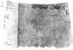
Chryse Planitia. This map is constructed from a series of
images acquired d by Viking (Orbiter 1 on revolutions 10,
20, and 22. Chryse Planitia is an area of plains that seems
Ins to be volcanic in origin. The surface is characterized
by mare-like ridges and relatively young impact craters,
although subdued or part-filled craters are also present. At
the left is a higher region of cratered terrain in which arc
several large channels. [USGS map M1M 23/50 CMC , 1977:
I-1068]
|
[163]

|
|
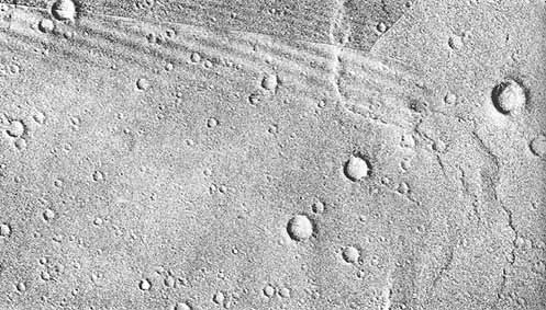
High Resolution Mosaic of the
Viking Lander I Site. The
periapsis of Viking Orbiter 2 was lowered to 300 km to
obtain high resolution images of the surface. The images
here were taken by the spacecraft on revolution 452, and
craters as small as 30 meters across can be seen. Craters A,
B, C, and D are the same craters as shown in the map of the
Yorktown region. Rims of craters (' and E can be seen in
images taken on the surface by Viking Lander 1.
[452B09-11]
|
|
|
|
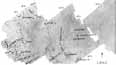
Yorktown Region of Chryse
Planitia. This map shows
Yorktown Crater-an 8-km diameter young impact crater at the
top left. Several branches of the Xanthe Dorsa mare-like
ridge system are also shown. The major craters on this map
have been tentatively assigned names to commemorate the 13
American colonies and the ports and countries with which
they traded. 'The craters labeled A, B, C, and D are also
shown in the mosaic below. [USGS map M250K 22/48 CMC, 1977;
I-1059]
|
|
[164]
|
|
Panorama of
Landscape. This view of part
of the horizon around Viking Lander 1 was taken shortly
after landing. At the left, about 100 meters away, is the
northwest portion of the rim of crater E in the high
resolution mosaic on the previous page. At the right is the
rim of (crater C, about 1.8 km away. The slight depression
in the foreground just to the right of center may be a
shallow, 3-meter-diameter secondary impact crater. [Viking
Lander I Camera Event 12A002]
|
[165]
|
|
Mosaic of the Canberra
region. This mosaic, an
enlargement of part of the mosaic of the Utopia Planitia
region on the previous page, shows the detail around the
site of Viking Lander 2. Most of the craters in this region
are the pedestal type, produced when wind scoured away
softer, more erodable material between craters and left
exposed the harder, more resistant material around the
crater rims. The larger craters have been tentatively named
for launch facilities, tracking stations, and mission
control centers used in 1976. [USGS map M250K 48/226 CM,
1977; I-1060]
|
[166]

|
|
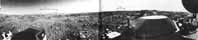
Panorama of
Landscape. This panorama of
the terrain surrounding the site of Viking Lander 2 was
taken by the spacecraft lander shortly after touchdown. The
large number of rocks and boulders was a surprise because
prelanding evidence suggested that the area would be covered
by a thin (tens of meters) sand sheet. Feature A on the far
horizon is believed to be ejecta from the rim of Mie Crater.
The large dip in the horizon was caused by the lander being
tilted. [Viking Lander 2 Camera Event 22A002]
|
[167]

|
|
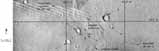
Mosaic of the Utopia Planitia
Region. Viking Orbiter 2
acquired these pictures on revolution 9 during landing, site
selection and certification for Viking Lander 2. This part
of Utopia Planitia is a polygonally fractured surface
covered by a thin layer of presumably windblown material
that has preferentially accumulated in the fractures. At the
extreme upper right is Mie, a 100-km-diameter impact crater,
approximately 200 km east-northeast of the lander. Mie
Crater is covered by sand dunes and deflation hollows, both
of which are strong evidence of wind activity. To the right
of bottom center is Hrad Vallis. [USGS map M1M 46/230 CM,
1977;I-1061]
|


