NASA SP-441: VIKING ORBITER VIEWS OF
MARS
- THE ATMOSPHERE -
[139] THE MARTIAN
ATMOSPHERE is persistently hazy. The haziness is due to the
scattering of light by suspended dust and condensate particles. This
haze causes the Martian sky to be gray to yellow instead of blue as
on Earth; the blueness of Earth's sky is due to the scattering of
light by air molecules. Superimposed on the Martian haze are various
types of local condensate clouds and fogs. At times, dust storms
raise great yellowish clouds that stand out against the haze and
ultimately contribute to it.
Because the axis of Mars is tilted with
respect to its orbit plane, the Martian atmosphere undergoes seasonal
changes analogous to those on Earth. Viking spacecraft arrived just
before northern summer solstice. Approach images show a relatively
dense haze covering the northern hemisphere and a much clearer
atmosphere in the south. With the beginning of southern spring, an
even denser haze blanket formed over the southern hemisphere, largely
obscuring the surface even from vertical view. Later this southern
haze thinned but, as southern summer approached, dust storms again
obscured far, e areas.
Northern latitudes were obscured by condensate
clouds and hazes during fall and winter in that hemisphere. North of
about 60° latitude, this "polar hood" was diffuse and
featureless and, because of the very low atmospheric temperatures s
in these regions, is believed to be at least partly carbon dioxide
ice particles. The zone between 40° and 60° N was swept by
fronts that moved south out of the polar regions; cloudiness was
associated with these weather systems.
Images of the Martian limb regularly show a
high, layered haze structure extending to more than 35 km above the
surface, with individual layers typically extending over large areas.
The vertical distribution of light-scattering particles is not
directly proportional to the brightness profile in the limb image.
This condition is because lower layers are seen along paths of
varying length through upper layers. The true distribution of
scatterers was calculated, and results revealed the existence of
clear layers between the cloudy ones.
The diffuse haze blanket itself is not without
structure. In some regions its features include broad longitudinal
streaks, cellular lumpiness, and wave trains. Cells, which range in
size from about 1 to 10 km, indicate convection within the haze
blanket. Wave trains up to several hundred kilometers long are
visible in a large percentage of high-altitude frames near the
morning terminator. These waves are visible because of the alternate
condensation and evaporation of ice crystals in the troughs and
crests of a pressure wave traveling through an atmosphere of high
static stability.
One prominent type of condensate cloud on Mars
forms around the giant volcanic mountains of Tharsis and Olympus.
These clouds, evidently formed [140] by orographic
uplift, form in late morning and obscure the flanks of the volcanoes
up to an elevation of about 20 km, leaving the summits unobscured. In
Earth-based observations, these clouds have bet n known for decades
as the "W clouds" because of their repeating configuration. Other
types of condensate clouds occur over less than 1 percent of the
Martian surface at any particular time. These include
convective-like-formations, cirrus-like wisps, and low-lying canyon
clouds.
Observers using telescopes have known for many
years that global-scale dust storms arc common when Mars is closest
to the Sun in its relatively elliptical orbit. Such a storm enveloped
the planet when Mariner 9 arrived at Mars. Two smaller global dust
storms were observed by Viking orbiters during the e extended
mission. The first occurred early in the southern spring, and the
other shortly after southern summer solstice. Both storms probably
started in the Thaumasia- Solis Planum region, and rapidly engulfed
most of the planet. They greatly affected meteorology at the landing
sites, and each prevented the acquisition of clear images of the
Martian surface for 2-3 months. Several dozen localized dust storms
were also observed by the Viking spacecraft. Most of these occurred
near the retreating south polar cap or in the region to the south of
the canyons on the southeastern slopes of Tharsis.
|
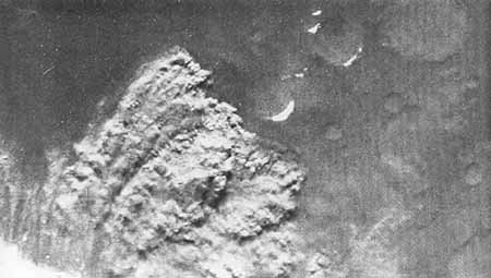
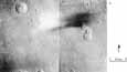
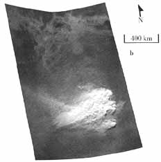
Water-Ice Cloud on Flanks of
Ascraeus Mons. This southern
view of the dawn side of Mars was taken during August 1976
by Viking Orbiter 2 as it approach' d the planet. Because it
was winter in the southern hemisphere at that time, the
south pole is in the dark. Part of the adjacent seasonal
frost cap is visible at tile bottom center. The great
equatorial canyon system, Valles Marineris, is faintly
visible at center right; but hazy atmosphere obscures
surface features north of that e except for the protruding
summit of the giant volcano, Ascraeus Mons. The white
feature on its western flank is thought to be a type of
water-ice cloud frequently observed in that region.
[P-19009]
|
[141]

|
[142]

|
|
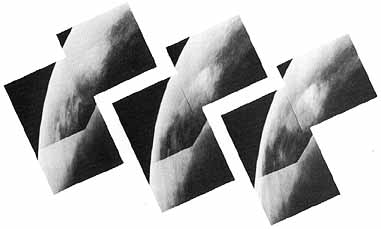
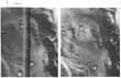
Early Morning Clouds in the
Tharsis Montes and Valles Marineris Region. Ascraeus Mons and Pavonis Mons are
prominently displayed in this mosaic, and dense cloud
blankets cling to their northern slopes. High cirrus clouds
lie to the west of Tharsis, and waves are visible in the
clouds surrounding the peaks. Bands of clouds appearing to
have a cellular structure extend north from the canyon, and
the areas within and immediately surrounding the chasm
exhibit water-ice fogs. [211-5049; 5°S,
105°W]
|
|
[143]

|
|
Wave and Dust Clouds in Arcadia
Planitia. This mosaic of
Viking Orbiter 2 frames shows an area north of Olympus Mons.
Surface detail north of 45° is obscured by the polar
hood. Well-developed wave clouds, seen at the upper right,
are produced by strong westerly winds perturbed by the large
crater, Milankovic (55 °N, 147° W). The wavelength
(distance between crests) of these clouds is about 60 km;
their persistence through more than 500 km implies stability
in the atmosphere which prevents the dissipation of the
waves by turbulence. The dust clouds at the lower left are
probably associated with passage of a cold front moving out
of the polar hood region. [211- 5373; 43° N, 124°
W]
|
[144]
|
|
Condensate Clouds over the Viking
Lander 1 Site. During the
summer, the northern hemisphere of Mars is generally quite
hazy-as shown in the Orbiter views taken in red, green, and
violet light (left to right) from a distance of 32 000 km.
Because all colors show some obscuration, the haziness is
probably caused by both dust and condensates. The large
diffuse cloud near the top center, however, is brighter in
violet light than in red, suggesting that it is largely
composed of condensates. It appeared over the Viking Lander
1 site in the (Chryse basin just a few days before landing.
[211-5143; 25°N, 45°W]
|
|
|
|
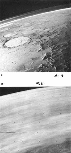
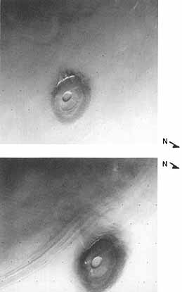
Changes in Atmospheric
Clarity. These two views in
violet light illustrate the dramatic change in the clarity
of the atmosphere in the region east and northeast of the
Argyre basin during winter in the southern hemisphere. (a)
Most of the snow-covered Argyre basin is shown. This was
taken just after the winter solstice when solar heating was
minimal. (b) This view was taken in late winter when the
area had started to warm. The cold southern regions may trap
water vapor from the much warmer northern hemisphere to form
these clouds, or water vapor may be released from the
seasonal polar cap as it retreats. [(a) 34A13, (b) 81B21;
47°S, 22°W]
|
|
|
[145]
|
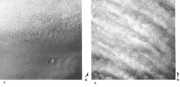
Wave Clouds. Wave clouds form in a stable stratified
atmosphere when winds pass over topographic features such as
crater rims. The distance between crests (wavelengths)
depends on the dimensions of the perturbing feature and on
the speed and vertical profile of the wind. (a) These
20-km-wavelength clouds seem to be formed by westerly winds
perturbed by the small ridge to the west of the clouds. (b)
This complex pattern of waves has wavelengths between 2 km
and 15 km, and may be connected with the south polar crater
field seen through the haze or perhaps with instability
induced by wind shear. The air is quite dusty in the
picture, which was taken in red light soon after the onset
of the second global dust storm. (c) This view shows waves
to the west of Argyre which are associated with a weather
system which also produced the Argyre dust storm. [(a)
40A21; 30°S, 88°W, (b) 287B43; 60°S,
154°W, (c) 131B64; 55°S, 65°W]
|
[146]
|
|
Cirro-Cumulus and Strato-Cumulus
Clouds. Clouds with cellular
structure resembling terrestrial cirro- cumulus and
strato-cumulus clouds are quite common on Mars, especially
in the polar-hood region. Small convective cells, created
when the base of the cloud layer is heated b! ground
radiation, are responsible for the structure. (a) Cellular
cloud layers are seen at the edge of the polar hood, viewed
from a distance of 15 000 km. Note the lee waves produced by
the crater. (b) View, taken from a distance of 1400 km, of
cellular clouds in the north polar hood, showing the
alignment of the cells into "streets." These features can be
produced by vertical wind shear. [(a) 470A07; 40° N,
210° W, (b) 138B53; 73°N, 318°W]
|
|
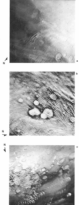
Limb Pictures. Limb pictures (those that include the edge
of the planet's disk) show that condensates, and perhaps
dust, exist in layers in the atmosphere up to 40 km above
the planet's surface. The limb structure in the southern
hemisphere is shown in (a) during the early winter and in
(b) during the late winter. View (c) depicts the north polar
limb and (d) the south polar limb. Both polar views were
obtained during the late summer for each hemisphere. [(a)
53A65; 40°S, 40°W, (b) 79B06; 48°S,
253°W, (c) 78B71; 80°N, 346°W, (d) 393B01;
78°S, 84°W]
|
[147]

|
[148]

|
|
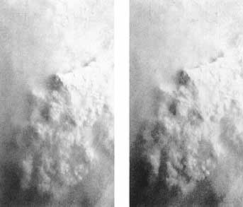
Clouds Surrounding Olympus
Mons. In this mosaic, Olympus
Mons, wreathed in clouds at midmorning, was viewed obliquely
(at an angle of 70° from vertical) from a range of 8000
km through a violet filter. The season is early summer when
Olympus Mons receives close to its maximum solar flux. The
top of the cloud blanket is about 19 km above the mean
ground level and 8 km below the summit. Water-ice, which
condenses as upslope air currents cool, is thought to form
these clouds. Parts of the cloud cover have a cellular
appearance, indicating convection within the clouds. A
well-developed wave cloud several hundred kilometers long is
visible toward the limb. [P-17444; 18° N, 133°
W]
|
|
|
|
Clouds around Pavonis
Mons. Early morning views,
taken 3 weeks apart, show Pavonis Mons, the central volcano
of the Tharsis Mons receives close to its maximum solar
flux. The top of the cloud blanket is about 19 km above the
mean ground level and 8 km below the summit. Water- ice,
which condenses as upslope air currents cool, is thought to
form these clouds. Parts of the cloud cover have a cellular
appearance, indicating convection within the clouds. A well-
developed wave cloud several hundred kilometers long is
visible toward the limb. (a) 40A95, (b) 62A18: 0°N,
113° W]
|
|
|
[149]
|
|
Discrete Clouds on Volcano
Slopes. Discrete clouds are
frequently seen above the slopes of the large volcanoes. (a)
The unusual plume cloud was repeatedly seen over Ascraeus
Mons in the early morning during the summer. (b) The cloud
shown is located over the northwest slopes of Ascraeus Mons;
the picture was taken when the local season was early autumn
and the time about 2:00 p.m. Picture (c) shows an unusual
combination of cirrus-like clouds, thin wave clouds, and a
prominent discrete cloud (which may be a turbulent rotor)
over Arsia Mons. [(a) 58A12;11° N, 105°W, (b)
225A05;12°N, 104°W, (c) 344B88; 9°S,
120°W]
|
[150]

|
|
Cirrus Clouds. Clouds resembling terrestrial cirrus clouds
are often seen in the Martian atmosphere. That these clouds
are condensate phenomena is well illustrated by the greater
contrast in (a), taken through a violet filter, than in (b),
taken through a red filter at the same time. Without shadows
to determine altitudes and a knowledge of temperatures at
the proper heights, it is difficult to distinguish water and
carbon dioxide ices. It is not improbable that both types of
cirrus clouds exist. The group of cirrus clouds in view (c)
occurred to the north of the Valles Marineris canyon system;
the varying orientations the clouds may indicate differences
in wind direction at the altitudes at which particular
clouds occur. Picture (d) shows a bright winter cloud as it
appeared over the Electris region. It was observed to recur
at the same place on several days during that season.
Bjerknes Crater is at the lower left. [(a) 101A10; 6°N,
244°W, (b) 101A07; 6°N, 244°W, (c) 58A02;
6°S, 76°W, (d) 88A03; 42°S,
192°W]
|
|
[151]
|
(a)
|
(b)
|
|
Cloud Shadows. Shadows of clouds may be used to determine
the altitudes of clouds. This information, coupled with
height profiles of temperature and pressure, can lead to a
determination of the composition of a cloud. In mosaic (a),
high-altitude clouds are seen over ancient, cratered terrain
to the east of the Hellas basin. Arrows connect three small
condensate clouds to their shadows, which appear to be about
200 km away. Using simple geometric relationships involving
the cloud, its shadow, and the sun elevation angle, one
finds the clouds to be at approximately 50 km altitude. View
(b) shows a larger (100 km long) cloud south of Valles
Marineris, about 50 km above the surface. At this altitude,
where temperatures and pressures are low, carbon dioxide is
the probable composition. [(a) 97A75, 77, 79, 81; 50°
S, 246° W, (b) 318A24; 20° S, 44° W]
|
|
[152-153]
|
- (a,b)
-
|
- (c,d)
-
|
|
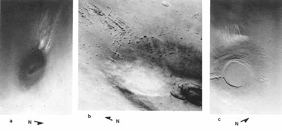
Enigmatic Clouds. These four frames show Martian atmospheric
phenomena that do not fit into any of the preceding
categories. Picture (a) is an unusual polar hood cloud
formation associated with the large crater, Mie.
Superposition of lee waves from parts of the terrain around
Mie could produce such a formation under appropriate
atmospheric conditions. In (b), a cloud in the southern
hemisphere can be seen; to catch the Sun's rays the cloud
must be high in the atmosphere. Linear, optically thin
streaks are seen in the Thaumasia region in (c). Streaky,
condensate hazes that have developed near the dawn
terminator during the onset of autumn in the southern
hemisphere are seen in (d). [(a) 470A05: 18° N,
220° W, (b) 211B60; 55° S, 234° W, (c) 67A06;
39° S, 85° W, (d) 431B03: 26°S,
280°W]
|
|
Early Morning
Surface Fog. The presence of
morning fogs in some crater and channel bottoms is a Viking
discovery with possible implications for the future
biological exploration of Mars. These early morning views of
the Memnonia region were taken one-half hour apart using a
violet filter to enhance the contrast of the condensates.
The areas marked by arrows are noticeably brighter in the
later picture. The fogs indicate specific spots where water
is exchanged, probably on a daily cycle, between the surface
and the atmosphere. The surface and lower air layers in this
region become unusually cold at night because of the thermal
properties of the surface. When the surface warms in the
morning, it seems that a small amount of water
vapor-estimated to be about one-millionth of a meter thick
if liquefied is driven off; this vapor recondenses in the
atmosphere, which warms more slowly, to form a ground fog of
ice particles. [P17487; 13°S,147° W]
|
|
|
[154]
|
|
|
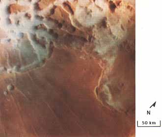
Early Morning Clouds in Noctis
Labyrinthus. Condensate
clouds are seen here in early morning in the canyons of
Labyrinthus Noctis, which lies at the western end of the
equatorial Valles Marineris system. This picture, which
covers about 90 000 km2, was made by combining three frames
of the same field taken through violet, green, and red
filters. Although these clouds lie mainly down inside the
canyons, they evidently extend above the walls and spill
over some of the surrounding plateau. Like most condensate
clouds in the Martian troposphere, they are believed to be
composed of water-ice crystals. [P18114, 9°S,
95°W]
|
|
|
|
Dust Storm in Argyre
Basin. A Iocal dust storm in
the Argyre basin near the end of winter in the southern
hemisphere is seen from a relatively high altitude point in
the elliptical orbit of Viking 2. Winds appear to he coming
from the west. The turbulent brown dust cloud near the polar
cap boundary is roughly 300 km across. This cloud did not
develop into a global dust storm of the type that tends to
occur a little later in the Martian year where Mars is
nearer to the Sun. Part of the receding seasonal frost cap
covers the lower half of this picture. It appears yellowed
by dust in the Argyre basin, but whiter in the mountains (at
bottom of picture) at the southern rim of the basin.
[P18598B; 50° S, 40° W]
|
|
|
[155]
|
|
|
South Pole Dust
Storm. This picture of the
periphery of the retreating ice cap was taken the day after
perihelion (Mars closest approach to the Sun). The cap had
shrunk considerably since the time of the Argyre storm
observation. The dust storm at the edge of the frost-covered
area, which is just visible in the corner of the picture, is
about 201) km across. Plumes of dust can be seen outside the
boundaries of the main storm. This picture shows the first
global storm in its last phase. Such storms are probably
related to winds induced by great surface temperature
contrasts. [248B57; 70°S, 60°W]
|
|
|
|
Local Dust Storms near Noctis
Labyrinthus. The region
southeast of the Noctis Labyrinthus complex on the slopes of
the Tharsis bulge seems to be particularly conducive to the
formation of local dust clouds. These frames were taken in
the middle of spring (a) and in late spring (b). Both local
dust storms occurred in the period between the two global
dust storms. The area in which the local storms occurred
slopes upward toward Arsia Mons. infrared Thermal Mapper
instrument data have shown that because of local differences
in surface thermal properties, large temperature contrasts
occur in this region. Downslope winds caused by these
temperature gradients may be strong enough to create such
clouds. [(a) 275B05-10, (b) 211B24; 14°S,
90°W]
|
 (a)
(a)
|
 (b) (b)
|
|
[156]
|
|
|
Dust Storm over the Chryse
Basin. These two pictures of
a dust storm over the Viking lander site in the Chryse basin
were taken 170 seconds apart. Motion of the clouds can be
detected if the pictures are viewed through a stereo viewer.
Analysis of the two pictures indicates that portions of the
cloud were moving from west to east with speeds ranging from
40 to 60 meters per second. This is consistent with westerly
winds at the surface with the unusually high speed of 22
meters per second as recorded by the lander. The lander
observation is, however, possibly in error because its wind
sensor was damaged. [467A69, 467A31; 22°N,
48°W]
|
|
Global Dust Storm. The early stages in the development of the
first global dust storm were observed by Viking Orbiter 2 in
the Thaumasia region. These images were taken 2 days apart.
In (a), a single frame, imaged in red light from a very high
altitude, includes the entire weather disturbance; the rest
of the southern hemisphere was rather clear at this time. In
(b), a mosaic, the frames were also taken through the red
filter. They show an area several thousand kilometers wide
seething with turbulent clouds of dust. This storm spread
rapidly to higher altitudes, and suspended dust obscured
much of the planet for a period of 50 days. Increased solar
heating as Mars nears perihelion is thought to provide the
energy that creates these large-scale disturbances. [(a)
176B02; (b) 211- 5379; 42°S, 108°W]
|
[157]
 (a) (a)
|
|
 (b) (b)
|
|
[158]
|

|
|
Low Pressure Cell near North
Pole. This Martian storm was
observed by Viking Orbiter at about 65° N latitude. The
local season corresponds to late July on Earth. The storm is
located near Mars' polar front, a strong thermal boundary
that separates cold air over the pole from the more
temperate air to the south. Shadows indicate that the clouds
are relatively low in the atmosphere. Because temperatures
in this region are well above the condensation temperature
of carbon dioxide, water ice is the probable constituent of
the clouds. Water vapor concentrations are high (by Martian
standards) during this season in the north polar
region.
This system strongly resembles
satellite pictures of extratropical cyclones near the polar
front on Earth. The counterclockwise circulation is
consistent with the winds normal low pressure
situation.
The frost-filled crater Korolev
(approximately 92 km in diameter) is located to the
northeast of the storm. The white patches in the top center
of the picture are outliers of the north polar remnant cap.
[783A42; 70° N, 200° W]
|
|
[159]
|
|
|
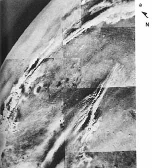
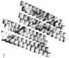
Cold Front. Viking Orbiter 2 photographed this cold
front in the Arctic region when the season on Mars was
equivalent to mid-May on Earth. During the 2 days between
the upper and lower mosaics, the front moved about 950 km,
at an average speed of 20 km/hr. The movement may he seen by
comparing the two mosaics: lines connect identical features
in the two sets of pictures. Weather systems like this
appear to be common in Mars' northern hemisphere. Viking
Lander 2 has detected the passage of similar fronts many
times. Warm, comparatively moist air is lifted over a wedge
of colder, denser air as it pushed south. Moisture in the
warm air condenses into ice crystals, forming clouds. Dust,
seen frequently in Martian storms, could also be present in
these clouds. Some water must be present, scientists say,
because wave clouds seen in both mosaics result from
condensation and evaporation of ice crystals in the troughs
and crests of pressure waves propagating in the atmosphere.
[211-5764; 65° N, 135° W]
|


