

|

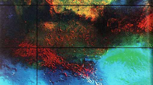
[169] DURING THE FINAL APPROACH to Mars, just before going into orbit, the Viking orbiters took a series of pictures of the planet with different color filters. As the planet rotated, different parts were photographed until almost the entire surface was covered. The pictures taken with the various filters were then compared, and the color at each point on the surface. was determined by means of a variety of sophisticated computer processing techniques. The results are displayed here as Mercator maps of the equatorial regions. The approach trajectory prevented good visibility of the polar regions, and they are not shown.
Although Mars has very distinct light and dark areas, differences in color are quite subtle. The appearance of the planet is dominated by variations in brightness or albedo that cause the classical markings known from telescopic observations. The color of the surface is a fairly uniform rusty brown, and differences are so small that they can barely be seen. To see the color differences, they must be artificially enhanced through computer processing at the same time, differences in brightness must be suppressed. Two color maps are shown here, one that approximates the natural color and another in which the color differences arc artificially emphasized.
Color is of considerable geologic interest because it allows remote detection of chemical and mineralogical differences. Only the upper few millimeters of the surface contribute to the color and on Mars this layer may be mostly wind blown debris. The bright materials that dominate the north equatorial zone are apparently aeolian deposits. Two units have been recognized. The upper unit is discontinuous, very red, and among the brightest of materials exposed at the planet's surface. The lower unit is darker and less red. The boundary between the two is generally serrated and has no relief. In the southern e equatorial belt, the color variations are apparently related to local bedrock and not to randomly dispersed aeolian debris. The dark highland region (0° to 40° S and 60° W to 30° E) is divided into (a) dark red ancient crater rims, rugged plateaus, mostly riddled with small channels , and graben; and (b) dark "blue" volcanic flows intermediate in age, and show very few channel networks. The large volcanic constructs in the Tharsis region and volcanic centers in the southern highlands northeast of Hellas are both very dark and very red.
Atmospheric phenomena and surface frost affect the planet's appearance. South of approximately 40° S, the scene is dominated by the annual south polar carbon dioxide fee cap. Near-surface condensate clouds arc abundant in this region, especially in Hellas. Because some of the data in the bright areas were saturated, the color balance is distorted; no attempt was [170] made to correct this problem. North of about 20° N, condensate clouds are especially noticeable along the northernmost edge where emission angles were extreme. Other clouds are scattered locally throughout the equatorial region south and southwest of Valles Marineris.