NASA SP-441: VIKING ORBITER VIEWS OF
MARS
- POLAR REGIONS -
[125] THE APPEARANCE of
the polar regions contrasts sharply with the rest of the planet,
partly because of varying amounts of frost cover and partly because
of some highly distinctive terrain not found elsewhere. Both poles
have a cap of frozen carbon dioxide that advances and recedes with
the seasons. In the north a small permanent residual cap left in
midsummer is composed of water ice. The composition of the small
residual cap left at the south pole is not known. The residual
northern cap is substantially larger than the residual southern cap,
so much so that the unique polar terrains of the north are rarely
seen without some frost cover. The polar scenes are all from Viking
Orbiter 2, which was placed in a high-inclination orbit specifically
to view the poles. Because its periapsis was in the high northern
latitudes, the highest resolution photographs are of the
north.
The most distinctive geologic features of the
polar regions are thick, layered deposits that cover much of the
surface poleward from 80°. The layering is best seen where the
frost has been preferentially removed such as on terraces and on
walls of valleys within the deposits. The layers, which range in
thickness from several tens of meters down to the resolution limit of
the available photography, can be traced laterally for considerable
distances. Unconformities occur but are relatively rare. In the
north, the layers rest on sparsely cratered plains; in the south they
rest on old cratered terrain. The layered terrain is almost
completely devoid of impact craters. Either resurfacing by erosion or
deposition is at a rate that is high compared with the impact rate,
or the impact craters "heal" relatively quickly by flow or
infilling.
The layered deposits arc believed to be
accumulations of volatiles and wind-blown debris, with the layering
caused by variations in the proportion and absolute amounts of these
two components. If this interpretation is true, then the layered
deposits preserve a partial record of the history of atmospheric
activity, and hence climate, in the recent geologic past.
A vast belt of dunes, several hundred
kilometers across, surrounds the layered terrain in the north. In
some areas, the dunes form a nearly continuous sheet that almost
completely masks the underlying topography. In other areas,
particularly around large topographic features, the sheet is
discontinuous and breaks up into strings of crescentic dunes or
isolated forms. Dune fields of comparable continuity do not occur
around the south pole, although numerous dark splotches on the
surface in the high southern latitudes are probably local dune
fields.
[126-127]
|
|
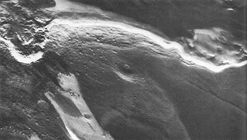
Photomosaic of North
Pole. This photomosaic
consists of some 300 Viking Orbiter 2 frames. Around the
north pole, curving in huge arcs, are dark bands where polar
frosts are absent. A giant ring of sand dunes surrounds the
polar region between 80° and 70° N latitude.
[211-5359]
|
|
[128]
Remnant North Polar Cap
Detail. This high-resolution,
closeup view was made by combining three black-and-white
images obtained through color filters. Above center in the
picture is a giant cliff about 500 meters high. Layers
averaging 50 meters in thickness are seen in the cliff face
and surrounding areas, which are highlighted by occasional
white patches of frost. The regularity of the layering
suggests that it comes from periodic changes in the orbit of
Mars - a relationship that, on Earth, may be at Ieast
partially responsible for ice ages. These orbit changes may
affect the frequency and intensity of global dust storms, in
turn varying the amount of material available to form
layered terrain. The cliff is apparently an erosional
feature; the variety of scarps shows the complexity of
erosion in the polar regions. Dune-like features (dark areas
with a rippled textures), possibly formed from material
eroded from the layered terrain, can be seen at the center
and at the right of the picture. Just above the scarp, the
polar ice layer is very thin and patchy; in other places it
appears to be considerably thicker. The maximum thickness of
the polar cap has not been determined. [75B52, 75B56, 75B58
(P-18459); 84° N, 237° W]
|

|
[129]
- (a)
- (b)
|
|
Layered Deposits Partially Covered
by Frost near the North Pole.
The light and dark pattern is caused largely by the presence
or absence of frost. The layers are best exposed on
southward facing slopes, which are generally without frost
and hence are dark. Although sequences of layers can
commonly be traced unbroken for considerable distances.
breaks in the sequence do occur. This pair of pictures
includes an example of an angular unconformity where one set
of deposits truncates another at an angle. In (a), the
unconformity is in the upper right center. In (b), an
enlargement of the area with the unconformity, the fine
scale layering of the sequence shows more clearly. [56B84;
80° N 339 °W ]
|
|
[130]
A Dune Field in Borealis
Chasma. Dark dune-forming
materials appear to have been transported away from the pole
in a curving stream extending from the top of this frame.
They arc accumulated in an approximately triangular dune
mass that occupies the center of the mosaic. The sinuous
ridges in the dune mass rotate in a clockwise direction
through an angle of approximately 45° from the northern
to the southern margin. The discontinuous dark texture on
the right side arises from partial dune cover. Perennial ice
is visible near the top of the frame and associated with the
crater near tile bottom of the frame. The bright patch near
center right may be a cloud. [58B21- 34; 48° N,
52° W]
|
|
[131]

|
|
Sand Dunes at the Rim of the North
Polar Cap. The dunes form a
sharp-edged, dark band near the bottom of this image.
Martian sand is dark, unlike Earth sands which are usually
light colored. This shows the minerals in Martian rocks most
resistant to erosion are the dark ones. The center of the
image shows a flat desert region. At the upper right are a
region of mottled terrain of unknown origin, a strip of
layered terrain (its layering clearly visible in this view).
and a pinkish-white region of polar frost. [IPL, ID:I2398AX;
81° N, 83° W]
|
[132]
 (a) (a)
|
[133] Widespread North Polar Edge Sand Dune
Fields. (a) Dunes here have a
consistent trend (approximately north-south) with minor
sinuosity, branching and merging. Vague circular forms are
probably buried craters, and bright spots within the ridges
are ice deposits. (b) Dunes with much more variation in
direction also occur; a shorter wavelength and greater
sinuosity appear in this dune field which adjoins and in
places appears to be mantled by frost deposits. Vague
circular forms again are probably buried craters. The bright
patches of ice near the upper left are associated with a
distinct change in the dune pattern, possibly indicating
that the deposits of ice preceded the development of the
present dune pattern. (c) Transition from a transverse ridge
structure to isolated linear and equant dunes. [(a) 59B32;
81° N, 141° W, (b) 58BO1; 80° N, 120 °
W, (c) 58B28; 78°N, 50° W]
|
 (b) (b)
|
 (c) (c)
|
|
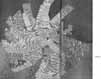
[134] Photomosaic of South Pole. At the left of this photomosaic is the
remnant south polar cap of Mars. Until recently, evidence
suggested that its composition was water ice like the
remnant north polar cap. New temperature measurements,
however, suggest that it may be carbon dioxide ice.
Extending from beneath the polar cap to the bottom of the
frame are large, lobate expanses of glacioaeolian deposits
with wind- scoured surfaces. At their northern margins,
these deposits overlap and partially fill a number of
craters. They also mantle the entire southern wall of a huge
impact basin, 800 km in diameter, which is approximately at
the center of the photomosaic. The unburied d part of the
basin rim, or rampart, forms a mountainous, semicircular
arc, with plains in the interior and a rugged landscape of
large craters stretching to the north. At the smallest
scales, the polar terrains exhibit mysterious patterns and
textures which can possibly be attributed to volcanic and
wind action, and to cyclical climate change. [383B04-75,
211-554 ]
|

|
[135]

|
|
Layered Materials Unconformably on
Cratered Terrain near the South Pole. Layered material with a smooth, uncratered
surface partly covers a 40-km diameter crater in the upper
half of the picture. Strings of secondary craters around the
larger crater are also transected by the layered deposits.
[383B50; 81°S, 271° W]
|
|
[136]
|

|
|
Secondary Craters in Layered
Materials Close to the South Pole. Layered deposits are shown in the lower half
of the picture but have been eroded away in the upper half
to form a low scarp to the north which is illuminated by the
Sun. Numerous secondary craters occur in the layered
deposits around a partly eroded crater. The relations
suggest that the crater formed after the layered deposits
but before the erosional episode that formed the
north-facing scarp. Part of the remnant cap is visible in
the lower left. [421B79; 85° S, 352° W]
|
|
|
|
Sinuous Ridges on the South Polar
Plains. The origin of these
ridges is unclear. They branch and rejoin like river
channels, and somewhat resemble terrestrial eskers (ridges
formed by deposits from subglacial rivers), but a volcanic
or tectonic origin is more likely here. Similar features
occur elsewhere on the planet, such as on the floor of
Argyre. [421B53; 78° S, 40° W]
|

|
[137]

|
|
Pitted terrain near the South
Pole. Some areas peripheral
to the layered deposits at the south pole appear to be
deeply etched with numerous irregularly shaped depressions
inset into a formerly planar surface. The depressions may
form by collapse after melting of ground ice or,
alternately, they may be simply deflation hollows formed by
removal of material by the wind. Similar features do not
occur at the north pole. [390B90; 77°S,
74°W]
|


