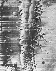
Home Table of Contents What's New Image Index Copyright ScienceViews Search


On Mars: Exploration of the Red Planet. 1958-1978


MARINER 9's MISSION


[288] Mariner 71 did not get off to an auspicious start, as Mariner 8's launch from Kennedy Space Center on 8 May 1971 ended in failure. Anomalies began to appear in the Centaur stage main engine after ignition. It shut down early, and the Centaur stage and spacecraft fell into the ocean. An investigation team determined the cause of the failure and worked out corrective actions before the 30 May launch of the second Mariner 71 craft.
 
At 6:35 p.m. EDT, Mariner 9 began its 398-million-kilometer direct- ascent trajectory toward Mars. Weighing 1000 kilograms at liftoff, the spacecraft carried six scientific experiments: infrared radiometer, to measure surface temperatures; ultraviolet spectrometer, to investigate the composition and structure of the atmosphere; infrared interferometer spectrometer, to measure surface and atmospheric radiation; S-band radio occultation experiment, to study the pressure and structure of the atmosphere; gravity field investigations; and the high and low resolution television imaging system, to map the surface of the planet. After a journey of 167 days, Mariner 9 went into Mars orbit on 13 November 1971, becoming the first spacecraft to orbit another planet. Orbital parameters were close to those planned, and the spacecraft circled Mars twice a day (11.98 hours per [289] revolution) at an inclination of 65°. Technicians referred to Mariner 9's path as 17/35-after 17 Martian days and 35 revolutions of the spacecraft the ground track would begin to repeat itself, giving the specialists the same images under essentially the same solar illumination. The Mariner planners had chosen a periapsis altitude of about 1250 kilometers to ensure some overlap when two consecutive, wide-angle A-frame images were recorded looking directly downward at the surface. Gaps between images acquired before or after periapsis could be filled in on a subsequent cycle 17 days later. 19
 
The NASA team sent Mariner 9 to the Red Planet at a time when the southern polar cap was shrinking and the southern hemisphere was undergoing its seasonal darkening, and the spacecraft instruments were designed to observe these phenomena. But Mars gave the Mariner scientists more than they had bargained for. On 22 September 1971, as the spacecraft made its way to its destination, ground-based astronomers noticed a brilliant, whitish cloud, which in a few hours covered the whole Noachis region of Mars. What they saw was the beginning of the greatest, most widespread Martian dust storm ever recorded.* 20
 
The progress of the storm was amazing. It spread from an initial streaklike core, some 2400 kilometers in length. On 24 September, the dust cloud began to expand more rapidly to the west, blanketing a large area from the east edge of Hellas (a proposed Viking landing site), west across Noachis in three days, a distance two-thirds of the way around the planet. To the north, Syrtis Major was beginning to disappear beneath the haze. On 28 September, a new cloud developed in Eos, a region later found to be part of the canyon lands of Mars. Peter Boyce, of the Lowell Observatory in Flagstaff, Arizona, reported that his observations taken in the blue-light spectrum had shown a reduction in contrast for several prominent features days before the dust cloud was visible to astronomers. This indicated that Martian dust had been drawn up into the atmosphere some time before the actual cloud could be seen. By the end of the first week in October, clouds or storms had engulfed nearly the entire planet. A zone about 12000 kilometers long had been obscured in only 16 days. Prospects were dim for a successful mapping of the planet when Mariner 9 reached Mars on 13 November. At Mariner mission control, there were some worried people, and the Viking team worried along with them.
 
On 8 November, the first pictures of Mars came back from the spacecraft. While these were essentially calibration shots designed to check out the television system, they were large enough to give a reasonably good view [290] of the planet. But the dust was all-pervasive; no detail could be discerned. One scientist, in a bit of gallows humor, suggested that they must have visited Venus by mistake, since that planet is perennially blanketed by clouds. His remark was not well received. With the loss Mariner 8 , the Mariner 71 project planners had completely reworked the missions they had scheduled for the two spacecraft. Mariner 8 was to have mapped the planet while Mariner 9 looked at the variable features of Mars, and both of these tasks were of great interest to Viking planners. The redesign of two missions into one had been accomplished while Mariner 9 traveled toward the Red Planet.
 
Mariner personnel members began a series of preorbital sequences to gather science data on 10 November. Originally they had hoped that these long-distance photographs of the whole planetary disk would provide them a global view of the surface. These images would have helped fill the gap between the low-resolution views obtained by Mariner 4 , 6 , and 7 and the higher resolution close-ups they were hoping to take with Mariner 9 . The first preorbital science picture revealed a nearly blank disk with a faintly bright southern polar area and several small dark spots. The intensity of the storm "shook everybody up," according to Hal Masursky, "because we could in effect see nothing." The key to their elaborate mission plan was a series of photographs that would be used in developing a control net for photomapping. That work was supposed to be done during the first 20 days after the spacecraft went into orbit, but they couldn't see a thing! The revised plan was dumped, and the Mariner operations team searched for items to photograph while waiting for the storm to subside.
 
Working with classical maps of Mars and more recently acquired radar data, the Mariner 9 television crew was able to demonstrate that one of the dark spots they could see in the science picture coincided with Nix Olympica (Snows of Olympus). That mysterious feature, often seen topped with bright clouds or frost deposits, was known from radar measurements to be one of the highest areas of the planet. Nix Olympica, towering through the dust clouds, was revealed as a very high mountain, the first Martian surface feature other than the polar cap to be identified by Mariner 9 . Computer enhancement of the 14 November images revealed volcanic craters in the summits of four mountains protruding through the pall of dust. This unexpected information led to the discovery that Nix Olympica and the three nearby dark mountains were actually enormous volcanoes, which would dwarf any found on Earth. But only these large features were visible. Other mapping sequences of orbital images produced a series of nearly featureless frames. Unhappily for the Viking team, adaptive photography brought pictures of things that did not aid its search for a landing site, like images of the Martian moons, Phobos and Deimos.
 
By 17 November, craters in certain regions began to appear in the television images as light-colored, circular patches. In similar fashion, an irregular, bright streak appeared running along the "canal" Coprates, [291] through Aurorae Sinus into Eos, the region of chaotic terrain identified by Mariner 6 and 7. Radar measurements had shown a depression several kilometers deep in this region. Indeed, the evidence, as incredible as it sounded, had indicated the presence of a huge canyon some 3000 kilometers long and varying in width from 100 to 200 kilometers. Beneath all that dust was a world of amazing topography. The Mariner and Viking science teams anxiously awaited their first clear view of that scene. In late November and early December, the dust storm seemed to be subsiding, but a couple of weeks later that trend slowed to a standstill. Worried scientists were relieved when the clearing process began again during the last days of the year. 21
 
While the dust storm had a significant impact on the Mariner 9 mission, its persistence through the month of November had a devastating effect on two Soviet probes launched on 19 and 29 May. Each of these craft weighed 4650 kilograms (nearly eight times the weight of Mariner 9 ) and consisted of an orbiter and a lander. The lander, containing a sterilized scientific package, was designed to enter the Martian atmosphere protected by a conical heatshield. Once the shield was discarded, the scientific instrument unit would descend on a parachute, and at about 20 to 30 meters above the surface the lander would be slowed further by a braking rocket. Those were the Soviet plans. On 27 November, just before Mars 2 entered orbit, the lander was ejected from the spacecraft to began a 41/2-hour journey to the surface. But something went wrong, and the lander crashed into the Martian surface at 44.2°S, 313.2°. Five days later, Mars 3 approached the planet and released its scientific cargo. After the descent, the craft landed safely at 45°S, 168°, and relayed a television signal to its parent craft in orbit. Success was short-lived, as the signal stopped after only 20 seconds. Soviet space scientists concluded that both failures were due to the storm raging on the surface. Unable to decipher the electronically coded television data, the Soviets could not determine what the surface looked like. Not only did the Soviet landers fail, but the dust storm outlasted the lifetimes of the imaging systems on both orbiters. Complementary data would have been useful for both the Mariner 9 and Viking teams, but the planet would not cooperate. Viking was likely to be the first craft to take pictures on the Martian surface, but only if it landed safely. And for many NASA planners, that was still an open question. 22
 
When the Viking Science Steering Group met at JPL in December 1971, one of its primary concerns was to learn what Mariner 9 could tell it that would affect Viking. Although the men participated in a weekly Mariner science evaluation team meeting designed to summarize the most recent scientific findings, they did not learn anything positive. The severe dust storm had foiled their efforts. Hal Masursky and his colleagues concluded that the Martian atmosphere might never completely clear, especially in the low areas, during the Mariner mission. If Mariner 9 did not acquire the reconnaissance data they required, Viking would have to perform the task, which made the instruments on the Viking orbiter even more [292] important. The Viking Project Office would have to keep "its options open" and give thought to several different models of the Martian surface, to be prepared for whatever Viking might encounter. 23
 
Clouds were clearing over Mars the third week of February 1972, however. During orbits 139 to 178, one mapping cycle of interest to Viking had been completed, covering the region from 25° south to 20° north. A second mapping cycle was in progress, and a third later that month would cover a Viking area yet to be determined. The coverage was reported to be very good. 24
 
Mariner scientists devoted the February session of the Science Steering Group to reports summarizing their recent data and comments on the implications for Viking. Most of what they had to say had already been made public during an early February press briefing held at NASA Headquarters. Bradford Smith, deputy team leader for the television experiment, had told reporters that the Martian atmosphere had begun to clear slowly in December, with more rapid progress during the first week of January. Pictures now available of the Martian surface led the science team to conclude that the planet was a far more dusty place than they previously had thought. But at that same press conference, Hal Masursky had some positive words about the dust storm. The first 30 to 40 days of the mission had given the scientists an opportunity to study the dynamics of the Martian atmosphere. "It will be 15 years....before such a large dust storm can be seen'' again. The storm, however, forced the mission planners to devise a reconnaissance scheme for looking at the planet from a higher altitude and photographing any clear areas with the high-resolution camera. Once the clearing trend started, the Mariner team began a new series of mapping sequences that were at least as complex as the original mission plan.
 
The mapping process revealed a fantastic planet, strewn with features that caught scientists' immediate attention. Huge volcanoes with attendant lava flows were found in the Tharsis region. And features that had been observed previously-such as three dark areas called North Spot, Middle Spot, and South Spot-were now clearly volcanoes. The caldera, formed by the collapse of the cone, of North Spot was 32 kilometers across, while the width of South Spot's crater was 120 kilometers. But these volcanoes were all dwarfed by Nix Olympica, which was renamed Olympus Mons. To the east of Tharsis, the Mariner team found a high plateau, much of which was 8 kilometers above the surface, that evidenced complex fault zones. Some areas had been uplifted; others had been depressed; in places large blocks had been tilted, "We think this indicates a very dynamic substratum under the Mars crust,'' Masursky noted, He showed the press some slides of the great chasm, which was some 4000 kilometers long and hundreds of kilometers wide at points. Looking at this complex of valleys and tributaries so recently obscured by dust, Masursky commented, "We are hard put to find a mechanism other than water to form this kind of complex, erosional channel. If it were not Mars, and if water weren't so hard to come by there, [293] we would think that these were water channels." This thought, pregnant with many possibilities, would require considerable analysis.
 
Masursky told the Science Steering Group that the scientific community was changing its thinking about Mars. After the 1969 flyby missions (Mariner 6 and 7 ), scientists still tended to believe, from the 165 low-resolution photographs taken from a distance of 3400 kilometers, that Mars was a dead primordial planet. But the Mariner 9 photographs illustrated a very different kind of place. The crispness of the edges on the volcanic piles and the absence of cratering seemed to indicate that these volcanoes were, geologically speaking, young. Just how young was uncertain. The fault zones showed that the crust had been broken many, many times, Mars evidently was a dynamic, geochemically evolved planet and not just a static accumulation of cosmic debris as some experts had theorized after the Mariner 1969 flights. With the realization that Mars was an active planet in geological terms, the search for possible life forms became more exciting. 25
 
Next at the February meeting, Al Binder described some of the work the Viking data analysis team was doing. A preliminary contour elevation map of the zone of interest to Viking had been compiled from 1967, 1969, and 1971 Earth-based radar observational data, which had been combined with Mariner 9 S-band occultation findings. To help determine the topography of Mars, the S-band experiment correlated the effects of temperature and pressure differences on radio signals through the thin atmosphere. Such maps would give clues as to which regions deserved a closer look and more detailed mapping later in the summer of 1972. 26
 
Jim Martin opened the second day of the Science Steering Group meetings on 17 February with a summary of the cost status of the project, particularly of the experiments, What followed could only be called a tough session. Each team leader explained what was being done in his project area to cut costs and under close cross examination defended his budget against future cuts. Everyone felt the pressure, so Mike Carr was not shy about arguing strongly for his orbital cameras. 27 Prefacing Carr's presentation, Conway W. Snyder, Viking orbiter scientist, described eight possible camera choices for Viking:
 
 
Alternative Choices
Savings
(in millions)

Delete cameras altogether

$17.80

Use Mariner TV cameras

3.30

Use augmented Mariner TV cameras

3.15

Mariner engineering

5.30

Viking imaging system without image motion compensation

0.40

Viking imaging system without photometric calibration

1.30

Viking imaging system without image intensifier

0.70

Delete above 2 items

2.00


Carr proposed that the photometric calibration and the image intensifier be dropped. This modified imaging system would permit double coverage but at one-half the resolution of the originally proposed system. The....


[294] In a mosaic (above left) of photos taken by Mariner 9 just before going into orbit of Mars in November 1971, computer processing reveals subtle details and swirls of dust. There is no suggestion that the dust storm is dispersing. Arsia Silva, most southerly of the three dark volcanic peaks, is slightly below the equator and 200 km in a diameter. Streaks are probably wind-driven clouds. Bright patches near the dark spots are artifacts of processing. Olympus Mons (above right), gigantic volcanic mountain photographed by Mariner 9 in January 1972 as the dust storm subsided, is 500 km across at the base, with cliffs dropping off from the mountain flanks to a surrounding great plain. The main crater at the summit - a complex, multiple volcano vent - is 65 km across. Mons Olympia is more than twice as broad ad the most massive volcanic pile on Earth. The meandering "river" in the photo below is the most convincing evidence found that a fluid once flowed on the surface of Mars. The channel, Vallis Nirgal, some 575 km long and 5 to 6 km wide, resembles a giant version of a water-cut arroyo, or gulley, on Earth. Mariner infrared spectral data, as well as Earth-based instruments, showed very little water on Mars, however. The Martian valleys also ressemble sinuous rilles on Earth's moon believed to be associated with lava flows, but no lunar rilles displays the branching tributaries seen here. Tha channel was first seen on 19 January 1972.


[295] Mariner 9's wide-angle TV camera on 12 January 1972 photographed the vast chasm at right, with branching canyons eroding the plateau. These featrures in the Tithonius Lacus, 480 km south of the equator, represent a landform evolution apparently unique to Mars. The ressemblance to treelike tributaries of a stream is probably superficial, for many of the "tributary" canyons are closed depressions. Subsidence along lines of weakness in the crust and possibly deflation by winds have sculptured the pattern. The photo, taken from 1977 km away, covers 376 by 480 km. The mosaic of two photos 
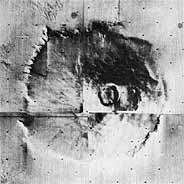
below, taken of Tithonius Lacus region from 1722 km, covers as area 644 km across and shows a section of Valles Marineris. Pressure measurements by Mariner's ultraviolet spectrometer registered a canyon depth of 6 km (the Grand Canyon in Arizona is 1.6 km deep). The dotted line is the UVS instrument's scan path. The profile line below shows measurements converted to relative surface elevations. The photo on the following page shows the full length of the canyon system.


[296] Panoramic view of the equatorial region on Mars was made from pictures taken by Mariner 9 from late January to mid-March 1972. Several hundred frames were scaled to size for the composite, which extends from 10° longitude at the right edge to about 140° at left. The photo map stretches more than one-third the way-around Mars and covers about 28 million sq km, about one-fifth of the planet's surface. The equator bisects the mosaic horizontally. At left, the complex of newly discovered giant volcanic mountains includes Olympus Mons, the largest. At least nine huge volcanoes have been pinpointed in Mariner 9 photos. Through the center runs the enormous canyon system Valles Marineris, 4000 km long, some 200 km wide at points, and nearly 6 km deep. (Portions are shown in the previous photos.) On Earth, the canyon system would extend from Los Angeles to New York.

 
[297]....modified Viking imaging system would also permit all data to be put into one tape recorder. The reduced resolution (about the same as the Mariner B-frame high-resolution images) was acceptable to the orbiter imaging team since the more important requirement for contiguous images could still be met. Snyder had pointed out that contiguous or overlapping photo could be obtained with the modified Mariner 9 cameras, but that the process of acquiring such photos on multiple passes would be long and inefficient. The orbiter imaging people took the position that the Mariner systems were not very suitable for Viking site certification; they wanted the modified Viking imaging system. They would, of course, have preferred the original system but were willing to give up parts of the initial concept to help pare the budget.
 
An executive session of the science group was held the next day. Once again, each team leader explained how he might save money, and NASA Associate Administrator for Space Science Naugle presented his perspective on the budget problem. After a few brief words of praise and the good news that Viking had passed a major hurdle-its fiscal 1973 budget had been established Naugle stated that the best program operating policy always called for setting a cost ceiling and adhering to it. He did not intend to give Viking financial relief because such a deviation from policy could have long-term disruptive effects on other aspects of the agency's program. True, there were funds being held in reserve, but Naugle stressed that they were a hedge against possible problems during the hardware development phase. Noting that the cost of the science payload had risen from $110 million to $160 million, the associate administrator made it clear that it was now necessary to make hard decisions to avoid more forced cost reductions in the future. While final decisions were not due until 1 March, Naugle gave his preliminary thoughts about cuts: he favored the proposed $2-million modification of the imaging system (Snyder's last alternative). 28
 

* C. Capen of the Lowell Observatory theorized in February 1971 that such a storm was possible. Sine 1892, astronomers have observed substantial dust storms each time an Earth-Mars opposition coincided with Mars' closest approach to the sun-1892, 1909, 1924-25, 1939, 1956. Because of the eccentricity of its orbit, the radiation received by Mars at perihelion is more than 20 percent stronger than usual. This increase substantially raises atmospheric and surface temperatures, and the resultant instabilities give rise to swirling columns of air lift dust and debris into the Martian sky.