-
On Mars:
Exploration of the Red Planet. 1958-1978
-
-
-
- THE SIGNIFICANCE OF
RADAR
-
-
-
- [319] As Klaus Biemann puzzled over argon
in the Martian environment, others on the Viking team were
tussling with an equally troublesome issue, radar. As a tool to
study planetary surfaces at great distances, radar seemed [320] to
have immense potential. A signal of a known strength could be
transmitted from one of the large radio astronomy antennas on
Earth- Arecibo in Puerto Rico, Goldstone in California, or
Haystack in Massachusetts- to the moon or Mars. The returned
signal could then be compared with known signal characteristics
and a judgement made about soil composition, the dimensions of
slopes and rocks, and other characteristics of a specific area.
Radar promised to give information on a scale of a few
centimeters, where orbital imaging would tell the site
certification team only about features that were larger than a
football field. Radar thus promised to be a powerful tool for
certifying landing sites, except that not everyone believed in its
promise, making it a controversial issue. Furthermore, this
technique could examine only a restricted range of latitudes on
Mars.
-
- While the Viking Project Office had been
planning all along to use radar as an aid to landing site
certification, Carl Sagan, once again acting as a catalyst, forced
the issue early in 1973. 6 On 3 February, Sagan wrote to Jim Martin, and
beneath the hyperbole of his prose Martin found some specific
steps that could be taken to rectify what Sagan saw "as serious
short comings in the landing site selection procedures." What
worried him most was the interpretation being placed on some of
the radar signals received from Mars. Some of Sagan's colleagues
saw visually smooth areas as sand or dune fields, but he
hypothesized that the low reflectivity of the radar was not due to
the scattering effect of sand grains and surface ripples but to
the absorption of the signal by a deep layer of dust. "At a recent
landing site working group meeting we were all entertained to see
a Viking lander sinking up to its eyebrows....While a similar
suggestion that lunar landing spacecraft would sink into surface
dust has proved erroneous, it by....
-
-
-
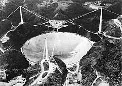
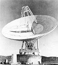
- The 305-meter-diameter radar dish
antenna at the Arecibo Observatory of the National Astronomy and
Ionosphere Center nestles in the Puerto Rico hills at left below.
At right below, the 64-meter dish antenna of the Deep Space
Network's Goldtsone, California, tracking station faces toward
space. Arecibo's reflector surface consists of 38 778 aluminum
panels, each about 1 by 2 meters, attached to a network of steel
cables. The radar feed mechanism, mounted on a 600-ton triangular
platform, is suspended by cables above the dish.
-
-
-
-
-
-
- [321]....no means follows that quicksand
is not a hazard for Mars. "He reminded the project manager that
the Soviets had suggested that quicksand might have been the cause
for Mars 3 's failure.
-
- As a consequence, Sagan made some
"explicit recommendations." First, he believed more serious
theoretical work was needed to understand better the meaning of
returned radar data. Second, Earth-looking radar on satellites and
aircraft could bounce signals off terrain thought to be analogous
to that on Mars, and as a data base was established scientists
could compare radar returns from unknown Martian surface areas
with known Earth terrains. Third, Sagan thought that major support
should be given to Arecibo, Haystack, and Goldstone Observatories
so they could examine Mars in detail during the 1973 and 1975-1976
oppositions. He noted that the Arecibo staff was resurfacing its
300-meter radar dish and would be installing a new transmitter.
Once these renovations were completed, the observatory would "have
a very impressive Mars mapping capability, which should be
exploited to the fullest."
-
- Turning to visual imaging, Sagan repeated
his concern that smooth surfaces at the 100-meter scale might be
rough at 10 centimeters. Had lunar surface data been analyzed to
determine if there was any relationship between roughness at the
two scales? Hal Masursky's people might look into this matter, and
similar correlation of Earth photos should also be studied. He
seriously doubted that one could make judgments about the nature
of the surface or the scale of the lander from any photographs the
orbiter was likely to produce. Sagan believed that radar, properly
understood and interpreted, was likely to be more useful in site
certification than all the photographs that would be taken.
7
-
- Sagan's concerns were important ones. Jim
Martin and Tom Young considered his recommendations, and on 23
March 1973 Martin wrote to Edgar M. Cortright, director of the
Langley Research Center. Martin planned to take three actions as a
consequence of Sagan's letter. Arecibo, Goldstone, and Haystack
radar facilities would make nearly simultaneous observations of
the same areas on Mars during 1973. Since the latitude base that
could be studied was limited to 10° to 20° south, none
of the candidate sites could be examined, but the information
would be valuable because it would contribute to the specialists'
understanding of radar's potential in such investigations. The
Arecibo team also agreed to make studies in the 1975-1976 period
and prepare a quick analysis of its data in the weeks before the
scheduled landings.
-
- The second action taken by the Viking
Project Office was to set up a radar study team, which would
undertake to eliminate some of the ambiguity in interpreting radar
data. On l March, Tom Young and Jerry Soffen met with Von R.
Eshleman and G. Leonard Tyler of Stanford University's Center for
Radar Astronomy, where they had been engaged in an active program
of analyzing and interpreting lunar radar studies. Tyler agreed to
lead the team that would work toward improving interpretation of
Mars radar information. Martin told Cortright, "As you are aware,
some of the [322] areas with low radar reflectivity are candidate
landing sites. We must better understand the meaning of the low
radar reflectivity to assure that the current sites are acceptable
or guide the selection of proper alternatives." Tyler had his work
cut out for him, and Martin arranged for a retreat at which a
small group could consider thoroughly the implications of radar
studies for Viking. 8
-
- Tyler presented the results of his study
to the landing site working group meetings at Langley on 4
November 1974. Basing his conclusions on data obtained from all
three radar facilities, Tyler noted that correlation between radar
features and Project Mariner imagery was poor. His study on the
large scale; Mars tended to have greater variation in surface
reflectivity than Earth or the moon; Mars appeared smoother than
the moon to the radar; the 100-meter resolution of the orbiter
camera system seemed likely to give appropriate information for
extrapolating down to the scale of the lander; and data for the
15° to 20° south band of the planet could not be applied
to latitudes in the north without variation. Jim Porter, keeping
minutes for this meeting, reported that both Tyler and his
colleague Gordon Pettengill "laced their presentations strongly
with tutorial material which greatly enhanced the ability of the
group to understand and correctly interpret their
findings."
-
- After listening to Tyler, the landing site
working group was unanimous in the opinion that the A and B sites
were still the best targets. Although the four targets A-1, A-2,
B-l, and B-2 were still believed to be in the correct order of
precedence (the Chryse site, A-1, receiving a strong vote of
confidence), the team became less enthusiastic in its endorsement
of the B sites. They also raised some questions about the C sites
that had been located recently at 9° south. The need for new
sites had been raised in early 1974 when some of the working group
members began to get nervous about what the orbiter's cameras
might find. Should the prime and backup sites prove unsatisfactory
or if operational difficulties should develop with the spacecraft
that would require the selection of some other safe landing spot,
they wanted a pair of "super safe" sites where radar,
photographic, and topographic information indicated that the
spacecraft would have the best chance of landing undamaged. A
special subcommittee* had been established to look into possible C sites
and make recommendations as early as possible.
9
-
- The work of the C site subcommittee took
longer than the working group anticipated. After meeting in
December 1974, the group met again on 6 February 1975 at the Jet
Propulsion Laboratory to recommend the study of three latitude
bands (8.5°S, 4°S, and 4°-6°N) that would be
visible to either the Goldstone or Arecibo radars during August to
November 1975. The radar specialists would observe each of these
regions as it became [323] accessible and recommended sites based
on combined radar and visual criteria to the Landing Site Staff,
the new name of the certification team, in September 1975. They
would repeat the process in November after the 4° north
coverage. From these observations, the Landing Site Staff would
develop a final recommendation in April for Tom Young, who had
become mission director. A detailed alternate mission design (for
the C sites) would be developed between December 1975 and May 1976
by Viking flight team members at JPL.
-
- A general feeling among the subcommittee
members was that the second mission should be targeted for one of
the C sites, since the available radar data indicated that some
regions on Mars were very unsafe for landers. The B sites were so
far north that radar coverage would never be possible. Norm
Crabill wrote in the minutes of the 6 February 1975 meeting that
apparently radar data could be used to reject sites, but it was
doubtful that it was sufficient to confirm a site. On the other
hand, Sagan and some of his colleagues did not want to rely on
photos alone. Despite all their earlier work, the landing site
specialists were still nervous about their efforts to find
suitable landing points for Viking. 10 Putting aside nagging uneasiness, the Science
Steering Group and the Landing Site Staff met in a joint session
at Langley to consider the recommended process for selecting the C
sites. After more discussion of radar as a tool, further
explanations of this complex business by Len Tyler, and additional
considerations of the argon problem, the joint group approved the
proposed plan for C site selection. 11
-
-
* Subcomittee
members included Chairman H.Masursky, N. L. Crabill, J. D. Porter,
L. Kingsland, G. L. Tyler, T. Owen, H. Moore, G. A. Soffen, and G.
A. Briggs.
-
-