|
COMETS EARTH JUPITER KUIPER BELT MARS MERCURY METEORITES NEPTUNE OORT CLOUD PLUTO SATURN SOLAR SYSTEM SPACE SUN URANUS VENUS ORDER PRINTS
PHOTO CATEGORIES SCIENCEVIEWS AMERICAN INDIAN AMPHIBIANS BIRDS BUGS FINE ART FOSSILS THE ISLANDS HISTORICAL PHOTOS MAMMALS OTHER PARKS PLANTS RELIGIOUS REPTILES SCIENCEVIEWS PRINTS
|
Related Document
Download Options
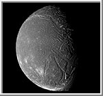
This image of Ariel is a a composite of four clear filter images taken by the Voyager 2 spacecraft on January 24, 1986, from a distance of 130,000 kilometers (80,000 miles). Two of these images that covered the terminator on the right were smeared because of the longer exposure times. Much of Ariel's surface is densely pitted with craters 5 to 1O kilometers (3 to 6 mi) across. These craters are close to the threshold of detection in this picture. Numerous valleys and fault scarps crisscross the highly pitted terrain. Voyager scientists believe the valleys have formed over down-dropped fault blocks (graben); apparently, extensive faulting has occurred as a result of expansion and stretching of Ariel's crust. The largest fault valleys, near the terminator at right, as well as a smooth region near the center of this image, have been partly filled with deposits that are younger and less heavily cratered than the pitted terrain. Narrow, somewhat sinuous scarps and valleys have been formed, in turn, in these young deposits. It is not clear whether these sinuous features have been formed by faulting or by the flow of fluids. This image is Copyright © 2001 by Calvin J. Hamilton. Any commercial/for-profit use of this image needs to be addressed to the Author. |
||||||||||||||||||||||||||||||||||||
