
Courtesy of NASA's National Space Science Data Center
Launch Date/Time: 2005-08-12 at 11:43 UTC
On-orbit dry mass: 1031 kg
Nominal Power Output: 1000 W
Description
Mars Reconnaissance Orbiter reached Mars and went into orbit on Friday, 10 March 2006. The signal that the orbit insertion burn started reached Earth at 21:24 UT (4:24 p.m. EST). It was behind Mars for about 30 minutes, the first signals following its reappearance reached Earth at about 22:16 UT (5:16 EST). One way radio travel time is 12 minutes at this distance.
The Mars Reconnaissance Orbiter (MRO) is designed to orbit Mars over a full martian year and gather data with six scientific instruments, including a high-resolution imager. The science objectives of the mission are to: characterize the present climate of Mars and its physical mechanisms of seasonal and interannual climate change; determine the nature of complex layered terrain on Mars and identify water-related landforms; search for sites showing evidence of aqueous and/or hydrothermal activity; identify and characterize sites with the highest potential for landed science and sample return by future Mars missions; and return scientific data from Mars landed craft during a relay phase. MRO will return high resolution images, study surface composition, search for subsurface water, trace dust and water in the atmosphere, and monitor weather.
Spacecraft and Subsystems
The Mars Reconnaissance Orbiter consists of a main bus, constructed of titanium, carbon composites, and aluminum honeycomb. Extending from the bus are two solar panel wings and a 3 meter high-gain antenna dish. The bus houses the propulsion system, telecommunications, command, guidance, and science instruments. The maximum spacecraft mass is 2180 kg, which includes 1149 kg of propellants.
Propulsion is provided by a total of 20 thrusters. Six 170 N (Newton) monopropellant (hydrazine) main-engine thrusters are used for the Mars Orbit insertion burn, a maneuver which will require about 70% of the total fuel onboard. Six 22 N thrusters are used for trajectory correction maneuvers and eight 0.9 N thrusters for pointing. All thrusters are fed from a single propellant tank mounted near the center of the main bus. A pressurant tank is used to force propellant to the motors. Spacecraft control is achieved with the use of reaction wheels and reaction control system thrusters. Navigation and attitude knowledge is determined by 16 sun sensors, two star tracker cameras, and two inertial measurement units, which use accelerometers and gyroscopes.
Two way telecommunications will be via X-band at about 8000 MHz, primarily through a 3 m diameter steerable high-gain dish antenna. Two low-gain Ka-band antennas, mounted on the high-gain dish, are also available for transmission and reception. Two transponders and three traveling wave tube amplifiers allow maximum data rates of 6 megabits/sec. Power is provided by the two solar cell arrays on wings mounted on opposite side of the bus. Each array has an area of 10 square meters and contains 3744 solar cells. The panels produce 1000 Watts at Mars which is used to run the equipment directly and also to charge two nickel-hydrogen 50 A-hr, 32-volt batteries. Thermal control is achieved by a combination of radiators, surface coatings, insulation, and heaters.
MRO's science payload includes the High Resolution Imaging Science Experiment (HiRISE), a visible stereo imaging camera; the Compact Reconnaissance Imaging Spectrometer for Mars (CRISM), a visible/near-infrared spectrometer to study the surface composition; the Mars Climate Sounder (MCS), an infrared radiometer to study the atmosphere, a shallow subsurface sounding radar (SHARAD) provided by the Italian Space Agency to search for underground water; the Context Camera (CTX), to provide wide-area views; and the Mars Color Imager (MARCI), to monitor clouds and dust storms. In addition, there are three engineering instruments aboard MRO: the Electra UHF communications and navigation package, which will be used as a relay between the Earth and future Mars missions; the optical navigation camera, which will be tested for possible navigational use on future planetary spacecraft; and the Ka-band telecommunications experiment package, which will be testing high performance Ka-band communications. Engineering accelerometer data will be used to study the structure of the martian atmosphere and tracking of the orbiter will be used to study the gravity field of Mars.
Mission Profile
Launch on an Atlas V-401 took place at 11:43 UT (7:43 a.m. EDT) on 12 August 2005 from Kennedy Space Center. The cruise to Mars will take about seven months and will include checkouts, calibrations, navigation, and five trajectory correction maneuvers. On 10 March 2006 MRO will reach Mars and perform a Mars orbit insertion maneuver, passing under the southern hemisphere of Mars and firing its main engines for about 27 minutes. Signals that the burn has started reached Earth at 21:24 UT (4:24 p.m. EST) on 10 March. With 6 minutes left in the burn MRO passed behind Mars as seen from Earth. Radio communication resumed when it re-emerged about 30 minutes later. The 1641 second burn slowed the spacecraft by about one km/sec, leaving it in a 400 x 35000 km polar capture orbit with a 35 hour period. Aerobraking will be used over the next six months to lower the orbit to the 255 x 320 km science orbit (with periapsis over the south pole and apoapsis over the north pole). There will be twelve sun-synchronous orbits per day so that the orbiter will always see the ground at 3:00 p.m. local time at the equator. Science operations will take place nominally from the end of solar conjunction in November 2006 to the start of the next solar conjunction in November 2008, roughly one martian year. Total cost of the mission is estimated at about $720 million.
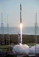 Mars Reconnaissance Orbiter (MRO) Roars Away
With the Atlantic Ocean as a backdrop, an Atlas V launch vehicle, 19
stories tall, with a two-ton Mars Reconnaissance Orbiter (MRO) on top,
roars away from Launch Complex 41 at Cape Canaveral Air Force Station at
7:43 a.m. EDT. All systems performed nominally for NASA's first launch of
an Atlas V on an interplanetary mission. MRO established radio contact
with controllers 61 minutes after launch and within four minutes of
separation from the upper stage. Initial contact came through an antenna
at the Japan Aerospace Exploration Agency's Uchinoura Space Center in
southern Japan. Mars is 72 million miles from Earth today, but the
spacecraft will travel more than four times that distance on its
outbound-arc trajectory to intercept the red planet on March 10, 2006.
The orbiter carries six scientific instruments for examining the surface,
atmosphere and subsurface of Mars in unprecedented detail from low orbit.
NASA expects to get several times more data about Mars from MRO than from
all previous Martian missions combined. Researchers will use the
instruments to learn more about the history and distribution of Mars'
water. That information will improve understanding of planetary climate
change and will help guide the quest to answer whether Mars ever supported
life. The orbiter will also evaluate potential landing sites for future
missions.
(Courtesy NASA/JPL/KSC/Lockheed Martin Space Systems)
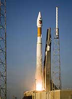 Mars Reconnaissance Orbiter (MRO) Lifts Off
At 7:43 a.m. EDT an Atlas V launch vehicle, 19 stories tall, with a
two-ton Mars Reconnaissance Orbiter (MRO) on top, lifts off the pad on
Launch Complex 41 at Cape Canaveral Air Force Station in Florida. All
systems performed nominally for NASA's first launch of an Atlas V on an
interplanetary mission. MRO established radio contact with controllers 61
minutes after launch and within four minutes of separation from the upper
stage. Initial contact came through an antenna at the Japan Aerospace
Exploration Agency's Uchinoura Space Center in southern Japan. Mars is 72
million miles from Earth today, but the spacecraft will travel more than
four times that distance on its outbound-arc trajectory to intercept the
red planet on March 10, 2006. The orbiter carries six scientific
instruments for examining the surface, atmosphere and subsurface of Mars
in unprecedented detail from low orbit. NASA expects to get several times
more data about Mars from MRO than from all previous Martian missions
combined. Researchers will use the instruments to learn more about the
history and distribution of Mars' water. That information will improve
understanding of planetary climate change and will help guide the quest
to answer whether Mars ever supported life. The orbiter will also evaluate
potential landing sites for future missions.
(Courtesy NASA/JPL/KSC/Lockheed Martin Space Systems)
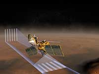
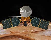 The Mars Reconnaissance Orbiter
This artist's concept of the Mars Reconnaissance Orbiter features the spacecraft's main bus facing down, toward the red planet. The large silver circular feature above the spacecraft bus is the high-gain antenna, the spacecraft's main means of communicating with both Earth and other spacecraft. The long, thin pole behind the bus is the SHARAD antenna. Seeking liquid or frozen water, SHARAD will probe the subsurface using radar waves at a 15-25 MHz frequency band, "seeing" in the first few hundreds of feet (up to 1 kilometer) of Mars' crust. The large instrument (covered in black thermal blanketing) in the center is the HiRISE camera. This powerful camera will provide the highest-resolution images from orbit to date.
The other easily visible instruments are: the Electra telecommunications package which is the gold-colored instrument directly left of the HiRISE camera. It will act as a communications relay and navigation aid for Mars spacecraft. To the right of the HiRISE camera is the Context Imager (CTX).
(Courtesy NASA/JPL)
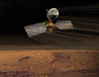
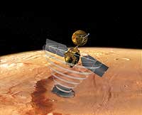 The Mars Reconnaissance Orbiter Using its SHARAD Radar
This image is an artist's concept of a view looking down on the Mars Reconnaissance Orbiter. The spacecraft is pictured using its SHARAD radar to "look" under the surface of Mars.
The SHARAD instrument will seek liquid or frozen water within the first few hundred feet (up to a kilometer) under the martian surface.
(Courtesy NASA/JPL)
 The Mars Reconnaissance Orbiter Using its Mars Climate Sounder Instrument
This artist's concept of the Mars Reconnaissance Orbiter at Mars features one of its instruments - the Mars Climate Sounder - in action. Using nine channels across the visible and thermal infrared ranges of the spectrum, the Mars Climate Sounder looks first at space through the atmosphere above the horizon of Mars to get a vertical profile with temperature, pressure, dust opacity and water vapor concentration measurements every 5 kilometers (3 miles) in the vertical from the ground to 80 km (~50 miles). It also looks down onto the planet to get surface temperature and column abundances of dust and water vapor.
These "profiles" and surface measurements are combined into daily, three-dimensional global weather maps for both daytime and nighttime. Observations will be made through the martian year to characterize the large seasonal variations in atmospheric dust loading, humidity and thermal structure, thereby providing scientists with the same type of information meteorologists use to understand and predict both weather and climate here on Earth.
(Courtesy NASA/JPL)
 The Mars Reconnaissance Orbiter in its Aerobraking Stage
This artist's concept of the Mars Reconnaissance Orbiter at Mars features one of its instruments - the Mars Climate Sounder - in action. Using nine channels across the visible and thermal infrared ranges of the spectrum, the Mars Climate Sounder looks first at space through the atmosphere above the horizon of Mars to get a vertical profile with temperature, pressure, dust opacity and water vapor concentration measurements every 5 kilometers (3 miles) in the vertical from the ground to 80 km (~50 miles). It also looks down onto the planet to get surface temperature and column abundances of dust and water vapor.
These "profiles" and surface measurements are combined into daily, three-dimensional global weather maps for both daytime and nighttime. Observations will be made through the martian year to characterize the large seasonal variations in atmospheric dust loading, humidity and thermal structure, thereby providing scientists with the same type of information meteorologists use to understand and predict both weather and climate here on Earth.
(Courtesy NASA/JPL)