|
COMETS EARTH JUPITER KUIPER BELT MARS MERCURY METEORITES NEPTUNE OORT CLOUD PLUTO SATURN SOLAR SYSTEM SPACE SUN URANUS VENUS ORDER PRINTS
PHOTO CATEGORIES SCIENCEVIEWS AMERICAN INDIAN AMPHIBIANS BIRDS BUGS FINE ART FOSSILS THE ISLANDS HISTORICAL PHOTOS MAMMALS OTHER PARKS PLANTS RELIGIOUS REPTILES SCIENCEVIEWS PRINTS
|
Related Document
Download Options
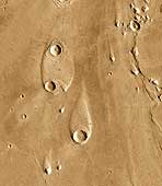
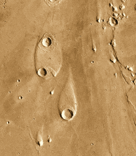
The water that carved the channels to the north and east of the Valles Marineris canyon system had tremendous erosive power. One consequence of this erosion was the formation of streamlined islands where the water encountered obstacles along its path. This image shows two streamlined islands that formed as the water was diverted by two 8-10 kilometer (5-6 mile) diameter craters lying near the mouth of Ares Vallis in Chryse Planitia. The water flowed from south to north (bottom to top of the image). The height of the scarp surrounding the upper island is about 400 meters (1,300 feet), while the scarp surrounding the southern island is about 600 meters (2,000 feet) high. (Image Credit: Calvin J. Hamilton; Caption: LPI) This image is Copyright © by Calvin J. Hamilton. Any commercial/for-profit use of this image needs to be addressed to Calvin J. Hamilton. |
||||||||||||||||||||||||