


|
| Table of Contents |
|
The Face on Mars Happy Face Hot Dog and Butterfly From Mars, With Love |
| Other Resources |
|
Mars Introduction The Viking Mission Mars Global Surveyor |
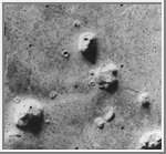 One of the most widely recognized features on a
world other than our own, is a mesa of resistant rock located in the Cydonia
region of Mars. It has a strikingly resemblance to a
human face, especially in older images taken by the
Viking Orbiters. The Cydonia region is
located along an escarpment that separates the relatively crater-free
planes to the north from the heavily cratered terrain to the south. JPL
scientists made the discovery of the "Face on Mars" in July of 1976 while
searching for a landing site for the Viking 2 Lander. Wanting to give the
public a familiar looking feature, JPL released the image to the right.
Based upon the low resolution Viking images (which was the best the Viking spacecraft could do), several people claimed that the "Face" was artificial and not a natural geological structure. They also put forth the proposition that other features in the area proved that an intelligent civilization once lived on Mars and created the formations. This became fuel for a small number of conspiracy theorists that asserted that NASA was trying to cover up evidence of ancient intelligent life on other worlds. This argument is preposterous, especially when one considers that NASA has always been faced with budget cuts. The best thing that could happen to NASA would be the discovery of ancient life or technology on another world. This would give them an overwhelming argument in convincing Congress for a large budget increase dedicated to further space exploration. I am not aware of any planetary scientist who believes that these features are anything more than natural formations.One problem with using the Viking images as proof of something is that they are low resolution. At such a resolution the images do not reveal crisp surface features. But a number of laywriters seem to be able to interpret quite a bit from these low resolution images, and some have published books and "supermarket tabloid" reports about their impressions, flawed as they may be. At maximum resolution, the face measures 46 pixels wide and 56 pixels high. The next highest resolution image was approximately 40 pixels wide by 48 pixels high.
| Face on Mars From Mars Global Surveyor | ||
|---|---|---|
 |
 |
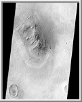 |
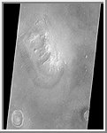
| MGS Image | Viking/MGS Comparison | MGS Image Inverted |
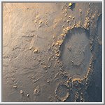 Happy Face
The story of the Mars Orbiter Camera (MOC) onboard the Mars Global Surveyor
(MGS) spacecraft began with a proposal to NASA in 1985. The first MOC flew on
Mars Observer, a spacecraft that was lost before it reached the red planet
in 1993.
Now, after 14 years of effort, a MOC has finally been placed in the desired mapping
orbit. The MOC team's happiness is perhaps best expressed by the planet Mars
itself. On the first day of the Mapping Phase of the MGS mission--during the
second week of March 1999--MOC was greeted with this view of "Happy Face
Crater" (center right) smiling back at the camera from its location on the east side
of Argyre Planitia. This crater is officially known as Galle Crater, and it is about 215
kilometers (134 miles) across. The picture was taken by the MOC's red and blue
wide angle cameras. The bluish-white tone is caused by wintertime frost.
Illumination is from the upper left.
(Courtesy Malin Space Science Systems/NASA)
 Hot Dog and Butterfly
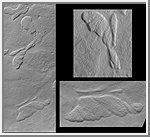
Some of the pictures returned from Mars by the Mars Orbiter Camera (MOC)
onboard the Mars Global Surveyor (MGS) spacecraft show features that--at a
glance--resemble familiar, non-geological objects on Earth. For example, the
picture at the left shows several low, relatively flat-topped hills (mesas) on
the floor of a broad valley among the mountains of the Nereidum Montes region,
northeast of Argyre Planitia. One of the mesas seen here looks like half of a
butterfly (upper subframe on right). Another hill looks something like a snail or a
hot dog wrapped and baked in a croissant roll (lower subframe on right). These
mesas were formed by natural processes and are most likely the eroded remnants
of a formerly more extensive layer of bedrock. In the frame on the left, illumination
is from the upper left and the scene covers an area 2.7 km (1.7 miles) wide by 6.8
km (4.2 miles) high. The "butterfly" is about 800 meters (875 yards) in length and
the "hot dog" is about 1 km (0.62 miles) long.
(Courtesy Malin Space Science Systems/NASA)
 From Mars, With Love
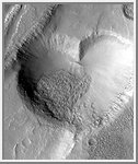
First, Mars seemed to be greeting Mars Global Surveyor (MGS) with
a Happy Face. Now, it seems as if the planet is sending its love
with the this picture from MGS's Mars Orbiter Camera (MOC).
This valentine from Mars is actually a pit formed by collapse
within a straight-walled trough known in geological
terms as a graben. Graben are formed along fault lines by
expansion of the bedrock terrain.
The heart-shaped pit is about 2.3 kilometers (1.4 miles) at its
widest. The image was targeted by the MOC team in order to
examine the relationship between a lava flow and the graben and pits that
disrupted and cut across the flow. The graben, pit, and lava flow
are located on the east flank of the Alba Patera volcano in
northern Tharsis. The MOC images are illuminated from the left.
(Courtesy Malin Space Science Systems/NASA)