


|
|
The Earth is a cradle of the mind, but we cannot live forever in a cradle.
- Konstantin E. Tsiolkovsky
| Introduction |
|---|
Shuttle astronauts are clearly fascinated by the topside view of Earth's atmospheric patterns that space flight provides, since every space shuttle crew takes a significant number of photographs of clouds. In the past two years, interest in clouds has increased considerably as scientists attempt to understand global warming and the greenhouse effect. Efforts to predict climatic changes associated with global warming have focused new attention on the warming and cooling properties of clouds. The picture is a complex one, involving competing feedback mechanisms, and is not fully understood at this time. All clouds block some fraction of the incoming solar radiation, and absorb some fraction of the heat radiated back from the Earth's surface, and the balance between these two processes is hard to quantify. However, contemporary thinking suggests that the lower altitude cumulus clouds (such as pictures Thunderstorms, Brazil and Cumulus Cloud Tops) have a net cooling effect on Earth's surface, reflecting heat back to space. Conversely, the higher, thin cirrus clouds (such as pictures Jet Stream Cirrus and Jet Stream Cirrus, Saudi Arabia) trap heat, reflecting it back to the surface of Earth.
Current data suggest that the cooling effects of great masses of cumulus storm clouds over the ocean at mid latitudes outweigh the heating effects of the upper-level cirrus clouds when considered on a global scale. Nevertheless, there is cause for concern because many models of global warming predict a decline in heavy mid-latitude cumulus storm clouds in the future. The amount of high-level cirrus cloud is predicted to rise as the cumulus decreases. If environmental and climatic changes result in altered weather and atmospheric patterns that adhere to these models, such changes will in turn induce accelerated global warming.
| Images of Clouds From Space |
|---|
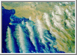
 Jet Stream Cirrus
This photograph taken from about 320 kilometers (200 miles) above
the Earth shows a band of cirrus clouds produced by a westerly jet stream
that stretches across the Red Sea from Sudan to Saudi Arabia.
The contained uniformity of the cloud formation reflects the narrow
track of the jet stream moving from left to right across the frame.
The shuttle photo shows that the cloud band comprises a series of
distinct and precisely spaced roll clouds. These
are created by a rolling motion in the upper level air current.
(Courtesy LPI/NASA. Picture #13-32-1099)
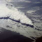 Florida Squall Line
This spectacular,
low-oblique photograph shows a convective line of thunderstorms associated
with a passing cold front over Florida. A shadow from the height of the
thunderstorms, caused by early morning sunlight, can be seen traversing
the scene southwest to northeast. The clouds in the
storm system rise to about 16,500 meters (55,000 feet). The V-shaped cloud
structure is normally associated with cold fronts that cross the Gulf of
Mexico and Florida in late winter and early spring. Severe thunderstorms
and tornadoes usually occur with this type of storm system. At the time
this photograph was taken, weather stations across Florida reported severe
thunderstorms, strong winds, hail, torrential rains, and numerous tornadoes.
(Courtesy NASA)
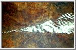
 Thunderstorms, Brazil
These cumulus thunderheads near São Paulo, Brazil, where
photographed from almost directly overhead by the STS 41-B crew. This
perspective conveys something of the energy that drives these cloud
columns to punch up into the atmosphere. The foreshortening resulting
from the near-vertical viewing angle disguises the fact that the
cloudheads so prominently in view are but the tops of massive thunderhead
storm clouds that can tower up to 18,000 meters (60,000 feet) in the tropics.
(Courtesy LPI/NASA. Picture #11-41-2343)
 Cumulus Cloud Tops
The STS 41-B crew shot this oblique photograph just moments after the
previous picture was taken. Some more fully developed thunderheads can
be seen in the same Brazilian storm. When the rising cumulus columns meet
the tropopause, or base of the stratosphere, at about 15,000 meters (50,000 feet), they
reach a ceiling and can no longer rise buoyantly by convection. The
stable temperature of the
stratosphere
suppresses further adiabatic ascent of moisture that has been driven
through the troposphere
by the 5-6.8 degree/kilometer (8-11 degree/mile) lapse rate. Instead, ice
clouds spread horizontally into the extended cirrus heads seen in this
photograph, forming the "anvil
heads" that we identify from the ground. The finer, feathery
development around the edges of some of the thunderheads is glaciation -
water vapor in the cloud is turning to ice at high altitude.
(Courtesy LPI/NASA. Picture #11-41-2347)
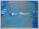
 Cloud Margin, Bering Sea
All that can be seen in this photograph is cloud stretching several hundred
kilometers to the limb of the Earth, yet it tells us a great deal about the
water in the Bering Sea below. The line or cloud margin running diagonally
across the frame with dense, thick cloud to the right and lighter, more
broken cloud to the left reflects an ocean current margin. A difference in
water temperature on either side of the margin is reflected in the cloud
forms condensing above. This striking cloud boundary stretches for 800-960
kilometers (500-600 miles) in this photograph.
(Courtesy LPI/NASA. Picture #17-41-058)
 Coastal Current, Namibia
Condensing moisture from ocean currents in some parts of the world creates
clouds that stay uniformly in position above that current for months at a
time. This example shows clouds hanging above the cold Benguela current,
which travels northward along the Atlantic coast of southwestern Africa. It
is interesting that while the ocean is densely cloud-covered and the clouds
lap at the coast, they never cross the coastline. The pinkish-colored
Namib Desert is one of the driest places on Earth, confirming that
the cloud associated with the ocean current does not stry off its
prescribed track. Indeed the Namib Desert is home to unique inhabitants
- insects with leg hairs
especially adapted to collect moisture from morning dew - a strange irony
of life on Earth where moisture-laden clouds hang so close by.
(Courtesy LPI/NASA. Picture #25-46-076)
 Unique Cloud Lanes, Oman
These wispy rows of cloud or "cloud lanes" are recognized as a
"landmark" by successive shuttle crews. This unique cloud
formation off Oman is virtually constant at certain times of year. The
clouds are created by a small vortex in the low level wind current. There
is little difference between the ocean and atmosphere temperatures here,
but the air current may have been subjected to heating from the Somali
Current.
(Courtesy LPI/NASA. Picture #2-10-649)
 Jet stream Cirrus, Saudi Arabia
This series of cirrus clouds is know as "roll clouds" because
they are sculpted into tight rolls by air currents from the jet stream
over Saudi Arabia and the Red Sea. The crest-to-crest spacing of the cloud
bands can be used to calculate the velocity of the jet stream.
(Courtesy LPI/NASA. Picture #13-32-1159)
 Jet Stream Convergence
This photograph taken over Namibia reveals another effect of jet
streams. Here two streams converge; cloud has formed in the corridor
between the two streams. Turbulence along the margins of the jet stream
may explain the sharp boundary. The point of convergence of the two air
streams is precisely located by this photograph. Shadows mark the cloud
edges against a sunlit Namibian backdrop.
(Courtesy LPI/NASA. Picture #13-31-092)
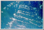 Cloud Streets, Tiladumati Atoll, Maldive Islands
Small cumulus clouds frequently form in parallel rows or "cloud
streets" in stable air conditions. These cloud streets over the reefs
of the Maldive Islands in the Indian Ocean denote the prevailing wind
direction, the cloud streets lying parallel with the wind. Turbulent
air lifted by the windward portions of the islands promotes cloud
formation downwind.
(Courtesy LPI/NASA. Picture #13-35-1459)
 Island Wake, Hawaii
The combination of warm water temperature and hundreds of square miles of
ocean, uninterrupted by land masses, results in a regular cumulus and
stratocumulus cloud formation. In the Pacific Ocean the Trade Winds propel
the clouds from east to west across the ocean. When the air current is
intercepted by a sufficiently high land mass, such as the Big Island of
Hawaii, the stable cloud pattern is interrupted and the clouds divide to
bypass the island in a wide arc forming an "island wake." In
addition to illustrating how gracefully the clouds circumnavigate Hawaii's
volcanic peaks, the photograph shows how the prevailing wind direction
dictates that the north and northeast of the island are wetter than the
western side of the island and frequently under cloud. The clouds deposit
rain on the low ground before dividing and spinning out to sea when they
meet the Kohala Mountains and Mauna Kea with its summit at 4,205 meters
(13,796 feet).
(Courtesy LPI/NASA. Picture #25-47-016)
 Cloud Tail, Lake Tana
Islands or high land, elevated above the surroundings and interrupting the
air stream, can produce "tails" as well as "wakes."
Shuttle astronauts have frequently observed Dek Island in Lake Tana in
Ethiopia, the source of the Blue Nile, with a well-developed cloud tail.
This occurs when the land mass disrupts the air flow, creating downwind
turbulence that promotes condensation. The lake stands at 1,800 meters
(6,000 feet) above sea level.
(Courtesy LPI/NASA. Picture #27-38-003)
 Open Cells over Ocean
Open cell formations like this are frequently found over ocean. The cells
are denser to the left of the frame than to the right, suggesting a
gradual warming in water temperature. By looking at this photograph and
studying the water color and cloud density, an expert could tell you which
ocean you are looking at, the time of year, and the temperature of the
water below. This picture was taken in the Indian Ocean, north of Australia.
(Courtesy LPI/NASA. Picture #11-37-1875)
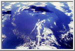
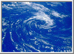 Anticyclonic Clouds
This pinwheel of anticyclonic clouds was photographed by the STS 41-B crew
over the southern hemisphere of the Pacific Ocean. The ground winds at
the center of this cyclonic system reach 80 kilometers per hour (50 miles an hour).
Circular storms in the northern hemisphere produce spiraling clouds
with a clockwise pattern, while southern latitude storms have a
counterclockwise cloud motion.
(Courtesy LPI/NASA. Picture #11-45-2834)
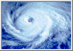
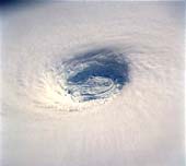
 Eye of Hurricane Kamysi
During the Solar Maximum Satellite Repair Mission, astronauts had an
excellent opportunity to look down the eye of Hurricane Kamysi over the
Indian Ocean. Clear blue water can be seen through the hurricane's eye,
and the crew reported that they could see the ocean wave below.
Unfortunately, the camera film could not pick them out.
(Courtesy LPI/NASA. Picture #13-35-1499)
Typhoon Odessa
Odessa is one of the strongest circular storm patterns seen by shuttle
crews to date and has a superb tightly formed eye. The tighter the eye in
a circular storm, the stronger the winds underneath. Mission STS 51-1
came to be known as the mission of all the hurricanes, tracking no less
than four circular storms around the globe. Live pictures from Discovery
of Hurricane Elena in the Gulf of Mexico were transmitted directly from
Mission Control in Houston to the National Hurricane Center in Florida for
correlation with conventional weather satellite and high level aircraft
data.
(Courtesy LPI/NASA. Picture #27-35-077)
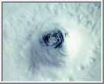
 Eye of Typhoon Yuri
This spectacular, low-oblique photograph shows the bowl-shaped
eye (center of photograph) of Typhoon Yuri in the western
Pacific Ocean just west of the Northern Mariana Islands. The
eye wall descends almost to the sea surface, a distance of
nearly 45,000 feet (13,800 meters). In this case the eye is
filled with clouds, but in many cases the sea surface can be
seen through the eye. Yuri grew to super typhoon status,
packing maximum sustained winds estimated at 165 miles (270
kilometers) per hour, with gusts reaching an estimated 200
miles (320 kilometers) per hour. The storm moved west toward
the Philippine Islands before turning northeast into the north
Pacific Ocean, thus avoiding any major landmass.
(Courtesy NASA)
 Sunrise
Space shuttle crews see a sunrise or sunset every 45 minutes as they
circle the Earth at 27,300 kilometers (17,000 miles) per hour, crossing
the surface at 6.4 kilometers (4 miles) per second. From their unique
perspective they see clearly defined
bands of color through the atmosphere as the sun rises. High-peaking
cumulus clouds, topping out in anvil-head cirrus can be seen as black
shadows against the sunlit horizon. The brightness of the colors in the
atmosphere in this photograph taken over the South China Sea is due to
concentrations of dust in the atmosphere. Greater concentrations of dust
are found in equatorial regions. There are various sources for such upper
level dust. Many dust storms in Africa, intensified by several years of
drought, have been responsible for putting large amounts of dust into the
atmosphere in recent times. Ash clouds from major volcanic eruptions can
have a similar effect. Recent discussion of the climatic and environmental
effects of a "nuclear winter" centering on upper atmosphere
pollution has drawn from the atmospheric effects of catastrophic volcanic
eruptions
(Courtesy LPI/NASA. Picture #14-32-014)
 Weather System Margin
The Discovery crew photographed this very distinct stripe running through
the clouds for several hundred miles. Two weather systems are sliding past
each other like crustal plates on the Earth's surface. The one at the top of
the photograph (geographical north) is moving up and curing away slightly
to the north, while the system at the bottom of the frame is moving
westward and curving gently to the south in conjunction with a cyclone
located several hundred miles away. The miniature cold-water gyres on the
fringes of the two weather systems indicate that a channel of colder water
runs under the break in the clouds and is reflected above where colder air
runs between the two cloud masses.
(Courtesy LPI/NASA. Picture #25-31-011)
| Acknowledgments |
|---|
This material was abstracted from the slide set:
Jones, Pat. Shuttle Views the Earth - Clouds from Space. Planetary Image Center/Lunar & Planetary Institute.
Copyright © 1997-2000 by Calvin J. Hamilton. All rights reserved. Privacy Statement.

 Earth
Earth