Home Table of Contents What's New Image Index Copyright ScienceViews Search


On Mars: Exploration of the Red Planet. 1958-1978


MARINER 69 SCIENCE RESULTS


[175] Scientific investigators from the Mariner 69 team presented a series of briefings and press conferences on their findings from the Mars flyby missions. The first major briefing and press conference were held on 11 September 1969, the day the preproposal briefings for prospective Viking science investigators were scheduled in Washington. While less tentative than the results presented at a 7 August press meeting, John Naugle indicated that the September briefings were really only progress reports. The final meeting of the scientists was scheduled for spring 1970, and more detailed accounts of individual experiments would be published in various journals.
 
Robert Leighton described the results of the television experiment at the September science briefing. "Before the space age, Mars was thought to be like the Earth, polar caps, seasons,. . . .rotates in 24 hours, etc." This view of the Red Planet "was largely the legacy of Percival Lowell who popularized the idea of reclamation projects to get the water supposedly from the polar caps down to the equator where the farmers were." Although scientists [176] had rejected the Lowell ideas of an inhabited Mars long before Mariner 4 , they were not prepared for the stark, lunarlike images acquired during that mission. Pictures from Mariner 6 and 7 , according to Leighton, showed that Mars was "like Mars," with its own characteristic features, "some of them unknown and unrecognized elsewhere in the solar system." 38
 
Leighton noted during the press conference that areas to be photographed by the Mariner 69 missions had been chosen to "cover as many different kinds of classically recognized features on Mars as possible, dark and light areas, oases." Mariner 6 's track traversed the equatorial zones and crossed a great many light areas, such as the circular great desert of Hellas, "and dark areas, like the region called Hellespontus. Mariner 7 took a sweep of pictures along a meridian (north to south) that included the south polar cap. The 60-fold increase in the data transmission rate produced for the 1969 spacecraft yielded many more pictures than the scientists had originally hoped.


Table 29

Pictures from Mariner Mars 69

Original Projection

Pictures Returned

Mission

Far Encounter

Near Encounter

Far Encounter

Near Encounter

Total Useful Pictures

Mariner 6

8

25

50

26

428

Mariner 7

8

25

93

33

749

Total

16

50

143

59

1177


Because of the large number of craters, the television team described Mars as more moonlike than Earthlike. In the Mariner 6 near-encounter frame 21, which covered a territory of 625 000 square-kilometers, there were 156 craters ranging in diameter from 3 to 240 kilometers, There were many hundreds more that were 500 meters across or smaller. The classical area Nix Olympica (18°N, 133°) was identified as a very large, "white-rimmed'' crater some 500 kilometers in diameter, with a bright spot in the center. Cratered terrain, the parts of the Martian surface on which craters are the dominant topographic form, were widespread in the southern hemisphere. Although knowledge of cratered terrain in the northern hemisphere was limited, since fewer photographs were available, some cratered areas appeared as far north as 20°. Two kinds of craters were seen in the pictures, large and flat-bottomed and small and bowl-shaped. Flat-bottomed craters were most evident in Mariner 6 frames 19 and 21, and their diameters ranged from a few kilometers to a few hundred. Shallow, they had a diameter-to-depth ratio of 100:1. The smaller, bowl-shaped craters, best seen in Mariner [177] 6 frames 20 and 22, resembled lunar primary impact craters, and some of them had interior slopes steeper than 20 degrees. The flat-bottomed craters were of interest to the Mariner 69 investigators because they were unlike most craters discovered on the moon.
 
The chaotic terrain seas a puzzle. Mariner 6 frames 6, 8, and 14 illustrated "two types of terrain-a relatively smooth cratered surface that gives way abruptly to irregularly shaped, apparently lower areas of chaotically jumbled ridges." A belt of the latter terrain lay within a band 1000 kilometers wide and 2000 long at about 20¡ south, between the dark areas Aurorae Sinus and Margaritifer Sinus. Perplexing the scientists because it was nearly craterless, this region of short ridges and depressions was unlike anything on the moon.
 
Hellas, centered at about 40° south, was the best example of the so-called featureless terrain. At the resolution limit of the 1969 cameras (the cameras could not see objects smaller than 300 meters in diameter), this desert area appeared devoid of craters. Leighton and his colleagues noted: "No area of comparable size and smoothness is known on the moon. It may be that all bright circular 'deserts' of Mars have smooth floors; however, in the present state of our knowledge it is not possible to define any significant geographic relationship for featureless terrain."
 
Especially bothersome was the fact that pictures taken during the Mariner 7 traverse showed that the dark area Hellespontus, west of Hellas, was heavily cratered. "The 130- to 350-kilometer-wide transitional zone is also well cratered and appears to slope gently downward to Hellas, interrupted by short, en echelon scarps and ridges." Once the flat floor of Hellas was reached, the craters disappeared. "Craters are observed within the transitional zone but abruptly become obscured within the first 200 kilometers toward the center of Hellas." The possibility of an obscuring haze was rejected because in Mariner 7 frame 26 "the ridges of the Hellas-Hellespontus boundary are clearly visible, proving that the surface is seen; yet there are virtually no craters within that frame. Thus the absence of well-defined craters appears to be a real effect." 39
 
In seeking to explain the relationship of these various kinds of terrain to the light and dark markings noted in telescopic observations, Leighton and his colleagues had a number of thoughts. First, the contrast of light and dark markings on Mars varied with wavelength, as had been known for a long time from telescopic photography. In the violet range of light, "bright" and "dark" areas were essentially indistinguishable since they have approximately the same reflectivity. With increasing wavelength, contrast was enhanced as redder areas became relatively brighter. The distinction between bright and dark areas on the surface was usually more obvious in far-encounter views than in near-encounter views. The clearest structural relationship between a dark and a bright area was that of Hellespontus and Hellas. Chaotic terrain appeared lower in elevation and at the same time more reflective than the adjacent cratered areas. Whether chaotic....


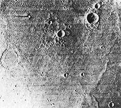
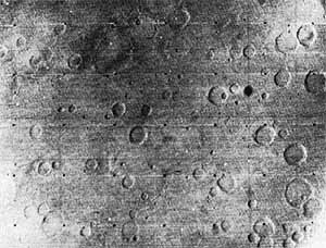
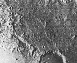
[Whole page 178] Mariner 6 took near-encounter photos of Mars on 31 July 1969. Frame 19 (above), 3613 kilometers from the surface, shows flat-bottomed craters a few kilometers to a few hundred wide, High-resolution frames 20 (left) and 22 (below) show smaller, bowl-shaped craters, resembling primary impact craters found on the moon.


[179]....terrain was extensive enough to include previously identified bright areas remained to be determined, Still, some of the areas traditionally thought of as oases were being identified with large, dark-floored craters such as Juventae Fons or with groups of craters such as Oxia Palus. In addition, at least two classical "canals" (Cantabras and Gehon) coincided with the quasi-linear alignment of several dark-floored craters, Other canals, showing up as irregular dark patches, would probably on closer inspection be associated with a variety of physiographic features. Leighton and his colleagues reported another correlation with earlier observations, Some drawings and "maps" of Mars portrayed a circular bright area within the dark region south of Syrtis Major and east of Sabaeus Sinus, In the Mariner 69 pictures, the investigators found a large crater in approximately the same place, The experimenters hoped to devote many hours to a comparison of these new Mariner pictures with earlier maps and photographs in an attempt to identify topographical features.
 
 
Clues to Evolution of Mars
 
 
What did the Mariner 6 and 7 pictures tell scientists about the evolution of the planet's surface? The absence of Earthlike tectonic forms indicated that in recent geologic time the crust of Mars had not been subjected to the kinds of internal pressures that have modified and continue to modify the surface of Earth. Since the larger craters probably had survived from a very early time in the planet's history, the scientists inferred that Mars' interior is, and probably has always been less active than Earth's. The TV experimenters noted that one theory argues that Earth's "dense, aqueous atmosphere may have been formed early, in a singular event associated" with the creation of the planet and its core. Tectonic features, therefore, might be related in origin to the formation of a dense atmosphere, and "their absence on Mars independently suggests that Mars never had an Earthlike atmosphere."
 
Building their case further for the unearthly nature of Mars, the television specialists commented on the age of the cratered terrains, comparing Martian surface features with similar features on the moon. Both bodies showed heavily cratered and lightly cratered areas, evidently reflecting regional differences in meteoroid bombardment, or response to it, over the life-span of the surfaces. The thin atmosphere on Mars (contrasting with no atmosphere on the moon) possibly had produced recognizable secondary effects in crater form and size distribution. Also, the scientific community generally accepted that the number of craters on the moon could not have been produced in its 4.5 billion years at the estimated present rate of impacts. An early era of high bombardment must have been followed by a long period at a greatly reduced rate. A rate per unit area as much as 25 times that on the moon was estimated for Mars. Since even the most heavily cratered areas seemed to have aged relatively uniformly, "this again suggests an early episodic history rather than a continuous history for cratered Martian terrain, and increases the likelihood that cratered terrain is primordial."
 
[180] The existence of primitive undisturbed terrain on Mars would have a number of important ramifications, especially for scientist looking for extraterrestrial life:
 
If areas of primordial terrain do exist on Mars, an all important conclusion follows: these areas have never been subject to erosion by water. This in turn reduces the likelihood that a dense, Earth-like atmosphere and large, open bodies of water were ever present on the planet, because these would almost surely base produced high rates of planet-wide erosion. On the Earth, no topographic form survives as long as 108 [100 million] years unless it is renewed by uplift or other tectonic activity. 40
 
Extrapolating further from this line of reasoning, the scientists found that the Martian environment apparently had not changed much during the life of the planet; thus, there was little possibility of a dense atmosphere or water that could have aided the evolution of primitive life forms.
 
Norman Horowitz, a biologist at Cal Tech and long-time participant in NASA exobiology studies, thought nothing in the new data encouraged the belief that Mars harbored life, "But the results also don't exlude this possibility." This was essentially what the exobiologists had expected, since Martian life was almost certainly microbial if it existed and would not be easily detected from flyby missions. "We have certainly seen no signs of the noble race of beings that built the canals or launched the satellites of Mars, I'm pretty sure they don't exist." Mariner 6 and 7 data did strengthen the earlier conclusion that water was extremely scarce on Mars and that was a seriously limiting factor for the search for life. While no clouds, frosts, or fogs had been seen in the new pictures, minute amounts of water vapor had been detected in the atmosphere. "Mars is a cold desert by terrestrial standards. If there is life on Mars, it must be a form of life that can utilize water in the form of water vapor or ice." Horowitz added that it was possible that extensions of our own terrestrial life, evolutionary adaptations," could live under such conditions. The exobiologist repeated what he had said many times: "The search for life on Mars is not sustained by optimism about the outcome. Anyone who is carrying on this work because he is sure he is going to find life, I think, is making a mistake. The search is sustained by the tremendous importance that a positive result would have, scientifically and philosophically, and until then we are obliged to continue the search." One of the major reasons they were exploring the Red Planet for life was to test their current notions about the origin of life. "We don't want to fall into the logical trap of using these notions to disprove in advance the possibility of life on Mars. We want to get there and make a direct test." 41
 
 
Effects on Mariner 71 and Viking
 
 
Leighton, during the 11 September 1969 press conference, said that each Mariner spacecraft had "in its turn revealed a new and unexpected, no doubt significant kind of terrainŠ.Now I leave it to you to figure out how many new surprises there are still waiting for us on Mars." While Mars [181] spacecraft evolved from one mission to the next, Leighton believed that he and his colleagues should not "fight the last war" with the Viking spacecraft. Instead, they must realize that they were still only its the initial stages of exploring Mars. "Flexibility in design [and] adaptability in execution" were incredibly important. 42
 
The distinctive new terrain revealed in the Mariner 69 pictures emphasized the importance of "an exploratory, adaptive strategy in 1971 as opposed to a routine mapping of geographic features." Very early in the first 90-day Mariner 71 mission, all of the planet should be examined with the A-camera, and selected targets should be studied with the higher-resolution B-camera, to correlate the extent and character of cratered, chaotic, and featureless terrains, and any new kinds of terrain, with classical light and dark areas, regional height data, and so on. Leighton and colleagues thought that a second objective should be the search for and examination of areas that indicated the possible presence of local water. The complex structure found in the south polar cap called for close investigation, particularly to separate the more permanent features from those varying daily or seasonally. A look at the north polar cap also promised to be "exceedingly interesting."
 
"If the effects of the Mariner 6 and 7 results on Mariner '71 are substantial, they at least do not require a change of instrumentation, only one of mission strategy. This may not be true of the effects on Viking '73." The Mariner 69 television specialists believed the discovery of so many new, unexpected properties of the Martian surface and atmosphere added a new dimension to selecting the most suitable landing site for Viking. Viking might be even more dependent on the success of Mariner 71 than had been supposed. From the improvement in the image resolution obtained by the 1969 B-cameras, scheduled also for use on Mariner 71, the team thought that an improved system might profitably be included in the Viking orbiter, designed to examine the fine-scale characteristics of terrains even more closely before choosing a landing site. 43
 
At its 11 September meeting, the Viking Science Steering Group agreed that a joint meeting of Mariner 69, Mariner 71, and Viking 73 scientists would be useful. Jerry Soffen suggested that such a session would permit a more thorough examination of the Mariner 6 and 7 information. At the same time, the science strategies for later flights to Mars could be more widely discussed, Plans called for the joint meeting to be held in early 1970 after the final selection of Viking investigators. Generally, Viking interest in the polar regions as a target for primary investigation diminished after hearing the early Mariner 69 reports." 44
 
The Viking orbiter science briefing on 12 September concentrated largely on the orbiter imaging system and its role in providing pictures that would help find landing sites. Orbiter science objectives included:
 
 
Of the 57 kilograms allotted for orbiter science instruments, more than half (32 kilograms) was set aside for the imaging system. For many months, the specialists would discuss alternative approaches to the design of the camera system, as technical and fiscal issues affected the final design of this important piece of Viking hardware. 45