Home Table of Contents What's New Image Index Copyright ScienceViews Search


On Mars: Exploration of the Red Planet. 1958-1978


SECOND SITE NO EASIER


[346] On 14 July, after one day off, the Landing Site Staff renewed its work, As part of the project's open policy, several reporters and photographers were permitted to watch the group in action. This meeting concentrated on....
 

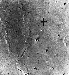
[347] Hal Masursky (above) on 12 July 1976 explains the geology apparent in the P22 photos. Jerry Soffen stands on his right. Across the mosaics, standing from right, are Tom Young, Jim Martin, Carl Sagan, Mike Carr, and an unidentified participant. Photo taken by Hans-Peter Bieman. Target for Viking 1 in Chryse Planitia at 22.4°N latitude, 47.5° longitude is shown in a photo taken 17 July. The area, photographed from 1551 kilometers away, is a smooth plain with many impact craters.


....engineering considerations affecting latitude selection for Viking 2 . The tenor of the discussions indicated that the C landing site latitudes were less favored than the B site region to the north, because the former were too high, too hot, and too dry. Debate continued as the Landing Site Staff once again tried to evaluate a landing zone without having seen the surface. 52
 
On the 16th, Hal Masursky led off the day's session by asking what they would learn if they could put a spacecraft down in each of the sites they had considered. A-1 was where the largest Martian channel complex opened onto Chryse Planitia. According to Masursky and Crabill, it was "the best area to observe where water and possibly near-surface ice had occurred in large quantities in the past-the optimum place to look for complex organic [348] molecules." B-1 had been selected because it was in a region where high water vapor concentration might be expected; also, at this longitude the two orbiters could provide relay support for either lander. C-1 and C-2 had been chosen because they had appeared safe to the radar team. The landing site team had to chose between B and C for Viking 2 . 53
 
Among others, John Guest, Mike Carr, and Ron Greeley presented their thoughts on the nature of Martian geology in these regions. Harold Klein gave his reasons for preferring B; central to his argument was water. And Josh Lederberg, also believed that there was a better chance for water at the northern latitudes. Vance Oyama dissented, saying that the B region was too cold; the temperature was always below freezing. The next day, only 4 members of the group were in favor of the C sites (5ƒS), while 30 wanted to go to the B region (44°N). Jim Martin reminded them he would have to make the final choice for the second mission by 3 p.m. 24 July. 54 A poll was taken again on the 21st after the first Viking 1 pictures of the surface had been studied-3 favored the C latitudes, while about 40 voted for B. 55
 
 
Worries about the B Sites
 
 
Cydonia (B.l, 44.3°N, 10°) had been chosen as the Viking 2 prime site because it was low, about five to six kilometers below the mean Martian surface, and because it was near the southernmost extremity of the winter time north polar hood. B-l also had the advantage of being in line with the first landing site, so the Viking 1 orbiter could relay data from the second lander while the second orbiter mapped the poles and other parts of Mars during the proposed extended mission. While this was a good spot to find water, * Masursky was worried about the geology of the region. He asked David Scott, who had prepared the geology maps, to work up a special hazard map for B- l. After studying the map, Masursky came to the conclusion that the area was not "landable," This analysis, of course, was made with maps based on Mariner 9 photographs. He told Tom Young and Jim Martin, however, that there was one hope; wind-borne material may have mantled the rough terrain and covered "up all those nasties we see."
 
The first pictures of B-1 were taken on periapsis 9, and it was worse than Masursky had imagined. "But it was not particularly a shock because I was scared to death of that site before it happened." Masursky proposed a big swath of pictures heading off to the northeast to about 57° north. Somewhere in the "Northeast noodle," he hoped that they would see the mantling develop and cover the rough terrain. Because of engineering constraints however, Viking could not land above 50° north. "So," according to Masursky, ``we cut off the noodle and. . . .called it the 'Northeast rigatoni'-that's a short noodle." 56
 
Meanwhile, the lander science team was having some worries of its own with the lander on the surface. The seismometer had failed to respond to....


[349] The first picture of the Viking 2 site were not very promising. Photos of the preselected primary landing site, Cydonia, were obtained 28 June by Viking I orbiter cameras from a range of 2050 kilometers. The rim of the crater Arandas is on the right edge. Rocks outcrop in the inner well, and ejecta form a lobate pattern with surface ridges and grooves. Small pedestal craters may have been caused by impact and etched out by wind. The center of the left photo is at 43°N latitude and 7.6° longitude; the right, 42.4°N latitude, 7.3° longitude.


.....actuation commands from Earth, and some transient communications difficulties had to be corrected But most significant for the Landing Site Staff, the sampler arm on the lander had stuck on the third day of the landed mission (sol 3). Although the Viking team was able to diagnose the difficulty, devise and test a solution, and free the sampler boom assembly in time to collect soil samples on schedule (sol 8), the problem emphasized the importance of safely landing Viking 2 . Simply put, if Viking 1 failed, then no chances could be taken in choosing a landing site for the second mission. All the tension and pressure experienced during the past month reappeared. 57

 
With the second spacecraft about 2.7 million kilometers from Mars, Martin told the press on Sunday, 25 July, that the navigators were going to make an approach midcourse maneuver at 6 pm PDT on the 27th to position the craft for orbit insertion on 7 August. Targeting the spacecraft for about 46° north, "we're going into an orbit which will allow us to spend some time observing three possible north latitudes. Two of them are known as B-l and B-2....We've spent a fair amount of energy looking for landing sites in B-l; so far we haven't seen anything I would like to put an ellipse in.'' Continued observation of the B-l "rigatoni" identified complex history of "aeolian deposition interleaved with erosion stripping." As Masursky and Crabill reported in Science , in some places secondary crater clusters peppered the small plains. In other areas, stripping of the uppermost aeolian [350] mantle had left secondary craters protruding as hummocks where crater ejecta had inhibited stripping. "In any case, the small areas of aeolian mantle were not large enough to locate an ellipse in, and the entire B-l region was rejected." 58 During the 27 July Landing Site Staff meeting, held just before the successful execution of the midcourse correction maneuver, Masursky indicated that there were several nice little spots in B-l but they were only one-tenth the size of the necessary landing ellipse. 59
 
A suitable landing site had still not been found in B-l when Viking 2 went into orbit on 7 August at 5:29 a.m. PDT. Project strategy now called for using the second orbiter in the search for a site at Alba Patera (B-2) or Utopia Planitia. Masursky and Crabill noted that coverage of Alba Patera during P4 and P7 ** "raised and then dashed hopes that it would prove to be a suitable landing site," On revolution four, the photo calibration sequence indicated a possible site in the northern region of Alba where Masursky had located his first ellipse using Mariner 9 images. As Young and Masursky watched the P7 pictures come in on the digifax machine, the region still looked smooth. Thinking they had found a likely prospect for a landing zone, they decided to get more pictures during the 15th orbit. 60 During the night, the mosaic team pasted up all the P7 photos, and Masursky was shocked by what he saw. Where the individual photos had shown a smooth terrain, the mosaic revealed a territory that was "rougher than hell.'' The difference was in the computer processing; under the proper processing, the region appeared very rough, covered by textured lava flows, Masursky thought to himself, "I think we've got a problem." He called for a special meeting of the landing team on 17 August.
 
Gentry Lee opened the 42d meeting with a review of the "fast breaking events'' since the previous day. After closer examination of Alba "smooth" spots, Masursky had concluded that it was not smooth enough. "Nothing in B-2 looks comfortable." Lee also noted that "we have an exhausted crew, as evidenced by the high frequency of errors in the products, from trying to maintain all four options." Those choices had been labeled B-2 early, the earliest site at which they could land; B-2 late, the latest site at which they could land; B-l; and B-3. Earlier that day, the Landing Site Steering Committee, an independent group of scientists advising Martin, had met and decided to drop the first three options and shoot for B-3. This decision was the most controversial action taken during the entire site selection-certification process. 61
 
Masursky recalled the events that led to that decision, At the 17 August steering committee meeting, he told Young and the others that B-2 was just no good; they did not need to break their backs getting the P15 photographs. Since B-2 was out, everyone also agreed to drop B-2 early, and Masursky concurred. But then someone suggested getting rid of B-2 late, as well. Masursky protested; they had not "even looked at the rest of the pictures in the B-2 area.'' However, they dropped the B-2 late option since it [351] would save work and time. The next recommendation was that a candidate they had been calling "B-l awful" be scrapped, too "We were taking six more sets of pictures there. . . .to see if we could find a site," Masursky remembered. Dropping "B- l awful" cut out another option. The meeting had lasted only 15 minutes, when others had lasted hours. Masursky left the session stunned: "We had committed the project to landing at B-3 where we had zero data." 62
 
What happened at that meeting? Gentry Lee reflected that each man in the Viking management had a different perspective and a different worry, even though they were all directed toward the same goal. From his perspective as manager of the Science Analysis and Mission Planning Directorate, he worried about his team; by mid-August he had a near mutiny on his hands. His people had to preserve four mission alternatives, To do that. "They had to do every day four times as much work as normal. They had to have a plan for what was going to happen eight days in the future on each of those options and so those poor people were just about to bite the dust." Norm Crabill also noted that the flight team was too tired to jump through any more hoops. Young and Martin saw the signs as well. Masursky was not happy with the decision, but being a team member and a team player he agreed to try for B-3. 63
 
B-3 called for a landing late on the afternoon of 3 September. From that location, called Utopia Planitia (47.9° north, 225.9°), 186 photos would begin coming in the night of the 17th and continue being played back until 2 am PDT on the 21st, All observations previously planned through P15 would still be made and processed, but no operational planning would be done for any of the B-1 or B-2 areas. 64 According to Masursky, the B-3 pictures looked terrible. While he was pondering the situation in the photomosaic room at JPL, he was visited by Henry Moore, who picked up a recently completed mosaic of B-2. Moore found what looked like "sand dunes all over that area" and called over his colleague. "Hank, I think you're smoking pot!" was Masursky's first reply, but when he looked at the mosaic he had to concede that there might be dunes. Because of poor exposure, it was difficult to tell, so they worked up special enhancements, "My God, that really looked good. That looks like that area is really covered by dunes." B-2 west was a promising area. Next they spotted smaller dunes in the B-3 region (48-49°N, 220°) that covered the ejecta blanket outside the large crater Mie (100 kilometers in diameter) and actually `vent into the crater. Farther to the west, some faint marks could be interpreted as the beginning of aeolian-deposited mantling material. This discovery led to a whole new debate: "Do dunes cover rocks, blocks and other hazards created by the erosional and cratering processes that might otherwise menace a lander?" 65
 
The dune controversy began on the afternoon of 18 August and continued through the final site review on the 21st. Openly admitting his preference for the B-2 area where they had spotted the dunes, Masursky developed a new argument for landing there. In the absence of lunarlike [352] mantles, dunes offered reasonable protection from rocks and blocks. Big dunes, as seen at B-2, offered better protection than the small dunes seen near the crater Mie. Before the meeting on the 21st, one of the landing site team members told Masursky that they would have to land at B-3. They could not "announce on Tuesday that all options are closed off except B-3, and them on Saturday decide to go back to B-2." Masursky believed they would "do the right thing." 66
 
On Saturday afternoon, 21 August, a formal review of two candidate sites-B-2 west and B-east-was held. During the first mission search, individual rock units had been mapped but, during the Viking 2 analyses, hazards had been defined in terms of debris ejected from craters, steep slopes, or areas subjected to different processes (stripping, mantling, and texturing). All these features had been mapped to determine favorable areas, `and those mapped features were the center of discussion. Tom Young reminded them that safety was the fundamental issue but that they must try to keep "the science factors visible." And Hugh Kieffer reported on his infrared thermal-mapping instrument (IRTM), which was being used as a `substitute for radar since there was no radar information for the northern sites. Masursky identified the five candidate ellipses:


B-3 East

alpha

47.2°N lat.

224.9° long.

B-3 East

beta

48.0°N

228.0°

B-2 West

I

44. 1°N

154.9°

B-2 West

II

47.3°N

156.6°

B-2 West

III

43.5°N

153.0° 67

 
In their report in Science , Masursky and Crabill evaluated these areas. The dunes in the B-2 region appeared to be bigger and apparently thicker than those in B-3. In B-3 there seemed to be some favorable aeolian mantle, even if it showed signs of being pitted. The northern part of B-3 looked better; cracks became shallower and craters were less abundant. Because of defects in some of the B-2 photos and an atmospheric haze that had obscured the surface, the interpreters were cautious in their estimates of the dunes in that zone. Some of the photogeologists believed that the decreasing number of small craters in B-3 would continue down to the scale of the lander. Some felt that the B-2 craters and ejecta blocks, being smaller than those in B-3, were better covered by B-2's bigger dunes and that B-3's smaller dunes might not cover the ejecta from the larger craters there as well. Still others favored site B-3 because they thought it appeared smoothed by uniform mantling. It was Tom Young's opinion that, although the geological conditions at B-2 east and B-3 west were different, the hazards gave them about the same safety ranking.
 
[353] Continued discussion at the meeting on 21 August centered on the size of the block hazards that they might encounter. Their best analyses predicted that the wind-borne mantling material was sufficient to cover the small blocks thrown out of the craters by meteoritic impact. In the region of the crater Mie, it was hard to project what size blocks could be anticipated. Rocks up to 10 meters in diameter were not ruled out, because of the ejecta measured in the Surveyor 7 lunar landing site and Apollo 15 , 16 and 17 high-resolution photographs of the moon. According to Masursky and Crabill, "The block populations depend on the number of small craters below the resolution limit that may excavate blocks from below the wind-laid mantle and the number exposed by deflation. Slopes were deemed acceptable based on Earth analogs, except on the inner margins of craters." 68 Hugh Kieffer's infrared thermal-mapping device did not provide conclusive assistance in selecting a site, When the pictures looked good, there were no IRTM data. Where the IRTM gave good results, there were no photographs. For no site were there both photos and IRTM information. From the IRTM, B-2 looked less blocky than B-3, but with the IRTM the latter looked a good deal like Viking 1 's landing point. After nearly two hours of discussion, a dinner break was called.
 
The meeting reconvened at 6:35 p.m. "Is there demonstrated evidence that a significant increment in safety exists in going to B-2 that warrants changing the current plan to go to B-3?" asked Tom Young. Mike Carr thought the larger dunes in B-2 argued for safety, but then so did the effects of wind in B-3. Klein and Biemann favored B-2 because more water might be present for the biology experiment. After a number of other opinions had been expressed, Young called for a show of hands on two questions: "Should we select B-3E/B-2W or continue to search? If we decide on a specific site tonight, should it be B-3E or B-2W?" Of those voting, 28 wanted a site; 9 wished to continue searching. The B-2 site would be chosen by 20, B-3 by 10.
 
Jim Martin concluded the open part of the meeting by requesting Tom Young, Gentry Lee, Jerry Soffen, Carl Sagan, Hal Masursky, Norm Crabill, Mike Carr, Hugh Kieffer, Conway Snyder, Brad Smith, Tim Mutch, and Bob Hargraves to attend an executive session of the Landing Site Staff. Young favored B-3 and enumerated his reasons: (1) Safety-B-3 appeared to be mantled, muted, and filled. With all that cover, it was hard to believe that there could be serious hazards to the lander. Since Carr and others were not particularly confident about B-2 because of the visibility problems, Young liked B-3 better, (2) Science-Young saw limited distinction between the two. B-2 might have a slight edge because of more water and higher temperatures, but those elements did not outweigh the safety differential between the two sites. As Masursky and Crabill pointed out, "The most significant scientific distinction had already been realized when the northern latitude band was selected.'' (3) Operations-The landing would be more straightforward at B-3. To land at B-2 would require additional data analysis, and [354] that would delay the landing significantly (according to Martin, the delay could be as long as two or three weeks). Such a delay, attended by greater operational complexity, did not seem to be justified by his readings of the two sites.
 
Project Manager Martin agreed with his mission director. He noted that several of the scientists wanted to do more ambitious exercises with the second lander, but he believed that additional observations of B-2 would work an already tired team into the ground. He could not see imposing such a killing load on the flight team. After some brief comments from others, Martin said they would go with B-3. It was safe enough; it had good enough science. There was no radar, but he was willing to take that risk. Gathering around the B-3 east stereo mosaic, the group determined the preliminary coordinates-48.0° north, 226.0°. 69 Final coordinates were chosen on 30 August after reviewing the P20 photographs: 47.89°N, 225.86°.
 
 
Renewed Drama
 
 
An orbital trim maneuver on 25 August 1976 ended Viking 2 's walk around the planet. Two days later a final trim synchronized the periapsis point relative to the landing site, which was centered 200 kilometers from the crater Mie, Before preseparation checkout of the second spacecraft, mission control put the first lander into the "reduced mission mode," permitting the flight team to concentrate on the second craft, At 9 am PDT on 3 September, the Viking Flight Team met for the "go/no-go'' separation meeting. With the exception of one of the terminal descent radar beams and a gyroscopic stabilizer that had given them some trouble, there were no problems with the spacecraft; all systems were "go" for separation. The radar problem was solved by locking out the troublesome unit, since the lander could touch down with only three of the landing radar beams functioning. And further analysis of the Y-axis gyro led the specialists to believe that it would not give them any trouble. Viking 2 was ready for the big moment-separation and descent to the surface.
 
When asked how he assessed the risks and dangers of the Utopia site as compared to the Chryse site, Martin replied that he believed Utopia was safe. Even without ground-based radar information, he believed the processing of the planet had laid a thick mantle of sand or soillike material over any rocks and obstacles such as seen around lander 1. The Utopia area appeared to have perhaps more undulations, hills, and valleys, but he thought the slopes were gentle, and only 10 percent as many craters were visible. To the query, "Do you call 155 foot [47-meter] high sand dunes a better landing area?'' Martin replied:
 
Well let me say that there was not unanimity in the selection of this landing site. My job is much easier when everybody gets up and says let's go this direction. Well, here we had a case where people were wanting to go in a couple of different directions. I still believe that from my own....


[355] A landing site for the second Viking lander is chosen in the eastern end of Utopia Planitia, 48°N latitude, 226° longitude. These three photos were taken by the Viking 2 orbiter on 16 August 1976 from 3360 kilometers away. Rough ground and craters appear blanketed by dunes.

 
....knowledge of sand dunes, that we can land on essentially any sand dune in the United States. I think the Lander is very tolerant to this kind of hazard. I think it is very intolerant to big rocks. So I would trade sand dunes for big rocks any day. 70
 
On 3 September, the world would be able to judge the wisdom of the landing site team's decision.
 
But there were some heart-stopping moments before Viking mission control knew that the lander was on the surface. Confirmation of separation came as scheduled at 12:39:59 p.m. Three seconds later came an indication that the orbiter had been upset. Twenty-six seconds later the power supply to the gyros on the orbiter cut out; the second power unit went out at 12:41:19. Without power, the inertial reference unit, which kept the orbiter aligned properly in space, could no longer control Viking 2 . As the spacecraft began to drift off course, its high-gain antenna lost contact with Earth. Within minutes of the failure, the orbiter's computer sensed the problem and commanded the backup inertial reference unit to take over arid stabilize the attitude of the spacecraft.
 
While the men in the Deep Space Network worked to regain contact with Viking 2 , the lander was on its way to the surface. To monitor the progress of the descending craft, the flight team tensely watched a small stream of engineering data coming down through the low-gain antenna. Throughout the Jet Propulsion Laboratory, project personnel, news people,....
 

[356] A view from the Martian north pole shows the location of the two Viking sites.


....and guests waited, subdued, for each little clue that would tell them all was going well.

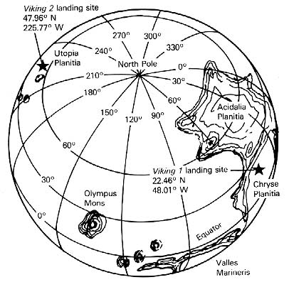
At 3:58:20 p.m. PDT (9:49:05 am. local Mars time) on 3 September 1976, the second lander touched down safely. Cheers mixed with sighs of relief, though the crisis was not over yet. The Deep Space Network worked with the flight team to get the proper commands to the orbiter. Once the spacecraft locked back onto its celestial reference point-the star Vega-Earth control again began to recover mission data, including the first two photographs taken by the lander's cameras immediately after the craft had reached the Martian surface. 71

 
Viking 2's landed photos illustrated a much rockier terrain than even the first site. One rock near the lander's footpad in the first picture looked as if it had been moved during landing. Martin and Young reported that the panoramic second picture revealed "a flat horizon and a landscape strewn with many rocks of various types. The tilt of the horizon indicates that the spacecraft may have landed on a rock." They also noted, "As a surprise, the panorama shows none of the sand dunes expected from the observations from orbit. A generally featureless terrain spreads flatly toward the horizon, more so than at the site of Viking 1 ." 72
 

* If the pressure was as high as 7.8 millibars the temperature rose above freezing, liquid water was possible at Cydonia.
 
** These orbit numbers (periapsides figues) are for the second mission.