|
COMETS EARTH JUPITER KUIPER BELT MARS MERCURY METEORITES NEPTUNE OORT CLOUD PLUTO SATURN SOLAR SYSTEM SPACE SUN URANUS VENUS ORDER PRINTS
PHOTO CATEGORIES SCIENCEVIEWS AMERICAN INDIAN AMPHIBIANS BIRDS BUGS FINE ART FOSSILS THE ISLANDS HISTORICAL PHOTOS MAMMALS OTHER PARKS PLANTS RELIGIOUS REPTILES SCIENCEVIEWS PRINTS
|
Related Documents
Download Options
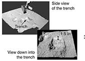
This image shows oblique views of NASA's Phoenix Mars Lander's trench visualized using the NASA Ames Viz software package that allows interactive movement around terrain and measurement of features. The Surface Stereo Imager images are used to create a digital elevation model of the terrain. The trench is 1.5 inches deep. The top image was taken on the seventh Martian day of the mission, or Sol 7 (June 1, 2008). The bottom image was taken on the ninth Martian day of the mission, or Sol 9 (June 3, 2008). The Phoenix Mission is led by the University of Arizona, Tucson, on behalf of NASA. Project management of the mission is by NASA's Jet Propulsion Laboratory, Pasadena, Calif. Spacecraft development is by Lockheed Martin Space Systems, Denver. |
