|
COMETS EARTH JUPITER KUIPER BELT MARS MERCURY METEORITES NEPTUNE OORT CLOUD PLUTO SATURN SOLAR SYSTEM SPACE SUN URANUS VENUS ORDER PRINTS
PHOTO CATEGORIES SCIENCEVIEWS AMERICAN INDIAN AMPHIBIANS BIRDS BUGS FINE ART FOSSILS THE ISLANDS HISTORICAL PHOTOS MAMMALS OTHER PARKS PLANTS RELIGIOUS REPTILES SCIENCEVIEWS PRINTS
|
Related Documents
Download Options
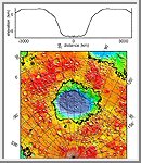
Regional topographic model of the Hellas basin. (Top) Azimuthally-averaged radial topography used in the calculation of infilling the basin with surrounding material postulated to have been excavated from it. (Bottom) Color-coded topography plotted in an equal-area projection. The black lines correspond to zero-elevation contours. The massive Hellas impact basin in the Southern Hemisphere is another striking feature on Mars. Nearly six miles (nine kilometers) deep and 1,300 miles (2,100 kilometers) across, the basin is surrounded by a ring of material that rises 1.25 miles (about two kilometers) above the surroundings and stretches out to 2,500 miles (4,000 kilometers) from the basin center. This ring of material, likely thrown out of the basin during the impact of an asteroid, has a volume equivalent to a two-mile (3.5-kilometer) thick layer spread over the continental United States, and it contributes significantly to the high topography in the Southern Hemisphere. |
