|
COMETS EARTH JUPITER KUIPER BELT MARS MERCURY METEORITES NEPTUNE OORT CLOUD PLUTO SATURN SOLAR SYSTEM SPACE SUN URANUS VENUS ORDER PRINTS
PHOTO CATEGORIES SCIENCEVIEWS AMERICAN INDIAN AMPHIBIANS BIRDS BUGS FINE ART FOSSILS THE ISLANDS HISTORICAL PHOTOS MAMMALS OTHER PARKS PLANTS RELIGIOUS REPTILES SCIENCEVIEWS PRINTS
|
Related Document
Download Options
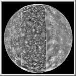
This mosaic was prepared from images obtained by three spacecraft: Voyager 1 (left side), Galileo (middle), and Voyager 2 (right side). The Voyager data were taken in 1979 but left a "gap" centered at longitude 290 degrees in the trailing hemisphere of Callisto. The Galileo Solid-State Imaging system photographed this area on its second orbit around Jupiter on 9 September, 1996 Universal Time. The resolution of the Galileo data is 4.3 kilometers/pixel (2.7 miles), meaning that the smallest visible feature is about 12 kilometers (7 miles) across. North is to the top of the picture. Features of interest in the new Galileo data include a dark, smooth area in the northern latitudes (upper third) which appears to mantle older terrain. This could be dark ejecta from a small impact crater. Also visible is a fresh, sharp-rimmed crater some 90 km (56 miles) across named Igaluk (center left third of picture), and a bright zone in the south polar area (bottom of image) which could be an impact scar. |
