|
COMETS EARTH JUPITER KUIPER BELT MARS MERCURY METEORITES NEPTUNE OORT CLOUD PLUTO SATURN SOLAR SYSTEM SPACE SUN URANUS VENUS ORDER PRINTS
PHOTO CATEGORIES SCIENCEVIEWS AMERICAN INDIAN AMPHIBIANS BIRDS BUGS FINE ART FOSSILS THE ISLANDS HISTORICAL PHOTOS MAMMALS OTHER PARKS PLANTS RELIGIOUS REPTILES SCIENCEVIEWS PRINTS
|
Related Document
Download Options
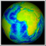
This rotating animation shows the distribution of topography on Earth. The colors blend smoothly from the lowest point (black) to highest point (white), with a full spectrum in-between: purple is low and red high. The movie clearly shows Earth's bimodal height distribution (continent/sea floor) and the effects of plate tectonics. The Earth DEM data used in creating this animation is courtesy of NOAA/NGDC. |
