|
COMETS EARTH JUPITER KUIPER BELT MARS MERCURY METEORITES NEPTUNE OORT CLOUD PLUTO SATURN SOLAR SYSTEM SPACE SUN URANUS VENUS ORDER PRINTS
PHOTO CATEGORIES SCIENCEVIEWS AMERICAN INDIAN AMPHIBIANS BIRDS BUGS FINE ART FOSSILS THE ISLANDS HISTORICAL PHOTOS MAMMALS OTHER PARKS PLANTS RELIGIOUS REPTILES SCIENCEVIEWS PRINTS
|
Related Document
Download Options
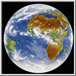
Rick Kohrs (rickk@ssec.wisc.edu) colored the image as follows. He used a threshold temperature to determine which pixels in the image corresponded to clouds. He then removed the cloud pixels from consideration. Since the temperatures over land and sea overlap, he used a base map to separate the remaining pixels into sea and land groups. At this point he had three partial images: (a) clouds, (b) unclouded sea, and (c) unclouded land. Based on temperatures he colored each of these separately using an appropriate fraction of the total number of cells available in an 8-bit color map. The combined image you see here uses the whole set of 256 colors. Rick Kohrs rickk@ssec.wisc.edu DaviD W. Sanderson dws@ssec.wisc.edu Space Science and Engineering Center University of Wisconsin-Madison (Image Credit: Space Science and Engineering Center, University of Wisconsin-Madison, Richard Kohrs, designer) |
