


|
 New Images Suggest Present-Day Sources of Liquid Water on Mars
Water is the chief agent of weathering and erosion on Earth.
Mars is a much drier, colder planet on which liquid water cannot exist very long at
the surface because it will immediately begin to boil, evaporate, and freeze--all
at the same time. However, new pictures from the Mars Orbiter
Camera (MOC) onboard the Mars Global Surveyor (MGS) have provided an astonishing
observation which suggests that liquid water may have
played a role in shaping some recent gully-like features found on the slopes of
various craters, troughs, and other depressions on the red planet.
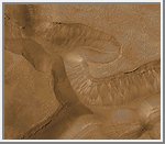
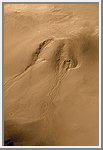
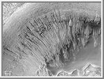
These pictures introduce the basic features of a martian gully. The figure on the left is an example from Mars, the figure on the right is a gully on Earth of the flank of Mount St. Helens volcano in Washington . In the Earth picture, rain water flowing under and seeping along the base of a recently-deposited volcanic ash layer has created the gully. For Mars, water is not actually seen but is inferred from the landforms and their similarity to examples on Earth.
The landforms both on Earth and Mars are divided into three parts: the alcove, the channel, and the apron. Water seeps from between layers of rock on the wall of a cliff, crater, or other type of depression. The alcove forms above the site of seepage as water comes out of the ground and undermines the material from which it is seeping. The erosion of material a t the site of seepage causes rock and debris on the slope above this area to collapse and slide downhill, creating the alcove.
The channel forms from water and debris running down the slope from the seepag e area. The point where the top of the channel meets the bottom of the alcove is, in many cases, the site where seepage is occurring. Channels are probably flushed-clean of debris from time to time by large flash floods of water released from behind an ice barrier that might form at the site of seepage during more quiescent times.
The aprons are the down-slope deposits of ice and debris that were moved down
the slope and through the channel. Whether any water--likely
in the form of ice--persists in these deposits is unknown. The fact that
the aprons do not go very far out onto the floors of craters and troughs
(e.g., the foreground of the figure on the left) indicates that there is
a limit as to how much water actually makes it to the bottom of the slope in
liquid form. Most of the water by the time it reaches the bottom of the slope
has probably either evaporated or frozen.
(Courtesy NASA/JPL/Malin Space Science Systems)
 "Weeping" Layer in Gorgonum Chaos
This image shows numerous examples of martian gullies that all start--or head--in
a specific layer roughly a hundred meters beneath the surface of Mars. These features are located on
the south-facing wall of a trough in the Gorgonum Chaos region, an area found
to have many examples of gullies proposed to have formed by
seepage and runoff of liquid water in recent martian times.
The layer from which the gullies emanate has recessed backward to form an overhang beneath a harder layer of rock. The larger gullies have formed an alcove--an area above the overhang from which debris has collapsed to leave a dark-toned scar. Below the layer of seepage is found a dark, narrow channel that runs down the slope to an apron of debris. The small, bright, parallel features at the base of the cliff at the center-right of the picture is a series of large windblown ripples.
Although the dark tone of the alcoves and channels in this image is
not likely to be the result of wet ground (the contrast in this image has been
enhanced), it does suggest that water has seeped out of the ground and
moved down the slope quite recently. Sharp contrasts between dark and
light areas are hard to maintain on Mars for very long periods of time
because dust tends to coat surfaces and reduce brightness differences. To
keep dust from settling on a surface, it has to have undergone some process
of erosion (wind, landslides, water runoff) relatively recently. There
is no way to know how recent this activity was, but educated guesses center
between a few to tens of years, and it is entirely possible that the
area shown in this image has water seeping out of the ground today.
(Courtesy NASA/JPL/Malin Space Science Systems)
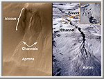
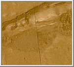
Gullies in Gorgonum Chaos
The first two pictures (top and above left) are from the Mars Global
Surveyor (MGS) Mars Orbiter Camera (MOC) and show a series of troughs and layered
mesas in the Gorgonum Chaos region of the martian southern hemisphere.
The picture at the top of the page is a portion of the picture on the left
above. The Viking view (above right) shows the location of the MOC image
in the chaotic terrain. Gullies proposed to have been formed by seeping ground
water emanate from a specific layer near the tops of trough walls,
particularly on south-facing slopes (south is toward the bottom of each
picture). The presence of so many gullies associated with the same layer
in each mesa suggests that this layer is particularly effective in storing
and conducting water. Such a layer is called an aquifer, and this one
appears to be present less than a few hundred meters (few hundred yards)
beneath the surface in this region.
(Courtesy NASA/JPL/Malin Space Science Systems)
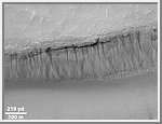
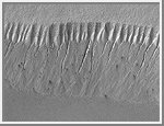 Gullies at 70°S in Polar Pit Walls
Gully landforms proposed to have been caused by geologically-recent seepage
and runoff of liquid water on Mars are found in the most
unlikely places. They typically occur in areas that are quite cold--well
below freezing--all year round. Like the old adage about moss on trees,
nearly all of them form on slopes that face away from sunlight. Most of
the gullies occur at latitudes between 30° and 70°.
The highest latitude at which martian gullies have been found is around 70°-75°S on the walls of pits developed in the south polar pitted plains. If you were at this same latitude on Earth, you would be in Antarctica. This region spends much of the winter--which lasts approximately 6 months on Mars--in darkness and at temperatures cold enough to freeze carbon dioxide (around -130°C or -200°F). Nevertheless, gullies with very sharp, deep, v-shaped channels are seen on the pit walls (above, left).
Based upon the locations of the tops of the channels on the slope shown
here, the inferred site of liquid seepage is located at a layer in the pit
wall about 1/3 of the way down from the top of the MOC image. The channels
start wide and taper downslope. The area above the channels is
layered and has been eroded by mass movement--dry avalanching of debris--to
form a pattern of chutes and ridges on the upper slope of the pit
wall. The top layer appears to have many boulders in it (each about the
size of a small house), these boulders are left behind on the upper slopes
of the pit wall as debris is removed.
(Courtesy NASA/JPL/Malin Space Science Systems)
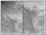
 Gullies in Crater Wall, Noachis Terra
Gullies eroded into the wall of a meteor impact crater in Noachis
Terra. This high resolution view (top left) from the Mars Global Surveyor
(MGS) Mars Orbiter Camera (MOC) shows channels and associated aprons
of debris that are interpreted to have formed by groundwater
seepage, surface runoff, and debris flow. The lack of small craters
superimposed on the channels and apron deposits indicates that these
features are geologically young. It is possible that these gullies
indicate that liquid water is present within the martian subsurface today.
The MOC image was acquired on September 28, 1999. The scene covers an
area approximately 3 kilometers (1.9 miles) wide by 6.7 km (4.1 mi)
high (note, the aspect ratio is 1.5 to 1.0). Sunlight illuminates this
area from the upper left. The image is located near 54.8°S, 342.5°W. The
context image (above) shows the location of the MOC image on the south-facing
wall of an impact crater approximately 20 kilometers (12
miles) in diameter. The context picture was obtained by the Viking 1
orbiter in 1980 and is illuminated from the upper left. The large mound on
the floor of the crater in the context view is a sand dune field. The Mars
Orbiter Camera high resolution images are taken black-and-white
(grayscale); the color seen here has been synthesized from the colors of
Mars observed by the MOC wide angle cameras and by the Viking
Orbiters in the late 1970s.
(Courtesy NASA/JPL/Malin Space Science Systems)
 Seepage Sites in "Aerobraking Crater" Revisited
The first clue that there might be places on Mars where liquid groundwater
seeps out onto the surface came from a picture taken by the Mars
Global Surveyor (MGS) Mars Orbiter Camera (MOC) during the pre-mapping
Orbit Insertion Phase of the mission. The picture, shown in (A)
above, was taken at the end of December 1997 while the spacecraft was
still in the midst of aerobraking maneuvers to put it into the circular
orbit needed for the Mapping Phase of the project. The Aerobraking 1
image, AB1-07707, showed dark, v-shaped scars on the western wall of a
50 kilometer-(31 mile)-diameter impact crater in southern Noachis Terra
at 65°S, 15°W (see B, above, for context). The v-shaped features taper
downslope to form narrow, somewhat curved channels. The relationship
seen here was interpreted by MOC scientists to be similar to seepage
landforms on Earth that form where springs emerge on a slope and water runs downhill.
Once MGS achieved its Mapping Orbit in March 1999, the MOC was in a better position to take pictures of 10 times higher resolution than the Aerobraking AB1-07707 image. The opportunity to take a new picture of the proposed "seepage" sites on the wall of the crater in southern Noachis finally arose in January 2000. The result is MOC image M11-00530, shown above in (C) and (D). This new close-up shows that the dark v-shaped scars host many small channels of only a few meters (yards) across. These small channels run downslope and coalesce at the apex (or point) of each "v". Amid the small channels are many large boulders, some of them the size of houses, that have eroded out of the crater wall. A 3-D view created using the AB1 and M11 images is shown in (E). The stereo picture (red-blue "3D" glasses required) emphasizes the presence of small channels and valleys, and shows that these valleys start almost at the very top of the v-shaped dark areas.
The context picture in (B) is a mosaic of Viking 2 orbiter images 497B47
and 497B48 acquired December 28, 1977. The Aerobraking MGS MOC
image, AB1-07707, is shown overlain on the Viking context image; it was
taken 20 years later on December 29, 1997. The smaller white box in
the context picture shows the location of MOC Mapping Phase image M11-00530,
roughly 2 years later on January 4, 2000. North is "up" in
pictures (A) and (B), and to the lower right in (C), (D), and (E).
Sunlight illuminates (A) from the upper left, (B) from the upper right, and (C)
and (D) from the upper right. The top image in (C) is the aerobraking image,
AB1-07707, with a white box indicating the location of the lower
image, M11-00530, and the stereopair in (E). The white box on the left in
(D) shows the location of the close-up on the right in (D).
(Courtesy NASA/JPL/Malin Space Science Systems)
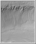 South-facing Walls of Nirgal Vallis
Nirgal Vallis is an ancient valley thought for nearly 3 decades to
have been carved, in part, by running water at some time far back in the
martian past. Today the valley is, like the rest of Mars, quite dry.
However, some of the high resolution Mars Global Surveyor (MGS) Mars
Orbiter Camera (MOC) images reveal small gullies on the walls of this
valley system. An example is shown here (above, left), in which more
than 14 channels nearly 1 kilometer (0.6 miles) long run down the
south-facing slope of the Nirgal Vallis wall. Each narrow channel starts at
about the same position below the top of the valley wall, indicating that
there is a layer along which a liquid--most likely, water--has percolated
until it reached the cliff, then ran down hill to form the channels and
the fan-shaped aprons at the bottom of the slope. Some of the apron
deposits seem to cover the dunes on the floor of the valley (lower 1/3
of the image), suggesting that the channels and aprons formed more
recently than the dunes. The fact that neither the dunes nor the aprons
and channels have impact craters on them suggests that these features
are all geologically young, meaning a few million years at most, a few
days or weeks at least.
Nirgal Vallis is the one location where martian gullies thought to be related to recent groundwater seepage have been found closer to the equator than 30° latitude. All of the features in Nirgal, however, occur close to 30°--they are all between 27°S and 30°S. The MOC image is near 29.7°S, 38.6°W, and was obtained July 12, 1999. The MOC picture covers an area approximately 2.3 km (1.4 mi) wide by 2.8 km (1.7 mi) long. Sunlight illuminates the MOC scene from the upper left, and north is up. The context view (right) is a mosaic of Viking orbiter images illuminated from the upper right from the U.S. Geological Survey Mars Digital Mosaic maps. The small white box in the context frame (just below center of image) shows the location of the high resolution MOC view.
It is ironic to note that one of the first pictures returned to Earth from
MOC, back on September 21, 1997, showed similar small channels and
aprons on the wall of Nirgal Vallis--but their significance was not realized at the time.
(Courtesy NASA/JPL/Malin Space Science Systems)
 Channels and Aprons in East Gorgonum Crater
This suite of Mars Global Surveyor (MGS) pictures provides a
vista of martian gullies on the northern wall of a 12
kilometer-(7.4 mile)-wide meteor impact crater east of the Gorgonum
Chaos region on the red planet.
The first picture (above left) is a composite of three different high resolution MOC views obtained in 1999 and 2000. The second picture (above right) shows the location of the high resolution views relative to the whole crater as it appeared in the highest resolution image previously acquired of the area, taken by the Viking 1 orbiter in 1978. The release image (top) shows a close-up of one of the channels and debris aprons found in the northwestern quarter of the impact crater.
Some of the channels in this crater are deeply-entrenched and cut into
lighter-toned deposits. The numerous channels and apron deposits
indicate that many tens to hundreds of individual events involving the
flow of water and debris have occurred here. The channels and aprons
have very crisp, sharp relief and there are no small meteor impact
craters on them, suggesting that these features are extremely young relative to
the 4.5 billion year history of Mars. It is possible that these landforms
are still being created by water seeping from the layered rock in the crater
wall today.
(Courtesy NASA/JPL/Malin Space Science Systems)
 Channeled Aprons in a Small Crater within Newton Crater
Newton Crater is a large basin formed by an asteroid impact that probably
occurred more than 3 billion years ago. It is approximately 287
kilometers (178 miles) across. The picture shown here (top) highlights the
north wall of a specific, smaller crater located in the
southwestern quarter of Newton Crater (above). The crater of interest was
also formed by an impact; it is about 7 km (4.4 mi) across, which is
about 7 times bigger than the famous Meteor Crater
in northern Arizona in North America.
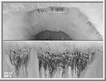
The north wall of the small crater has many narrow gullies eroded into it. These are hypothesized to have been formed by flowing water and debris flows. Debris transported with the water created lobed and finger-like deposits at the base of the crater wall where it intersects the floor (bottom center top image). Many of the finger-like deposits have small channels indicating that a liquid--most likely water--flowed in these areas. Hundreds of individual water and debris flow events might have occurred to create the scene shown here. Each outburst of water from higher up on the crater slopes would have constituted a competition between evaporation, freezing, and gravity.
The individual deposits at the ends of channels in this MOC image mosaic
were used to get a rough estimate of the minimum amount of water
that might be involved in each flow event. This is done first by assuming
that the deposits are like debris flows on Earth. In a debris flow, no less
than about 10% (and no more than 30%) of their volume is water. Second, the
volume of an apron deposit is estimated by measuring the area
covered in the MOC image and multiplying it by a conservative estimate
of thickness, 2 meters (6.5 feet). For a flow containing only 10% water,
these estimates conservatively suggest that about 2.5 million liters
(660,000 gallons) of water are involved in each event; this is enough to fill
about 7 community-sized swimming pools or enough to supply 20 people with
their water needs for a year.
(Courtesy NASA/JPL/Malin Space Science Systems)
 Gullies in Sirenum Fossae Trough
This mosaic of two Mars Global Surveyor (MGS) images shows
about 20 different gullies coming down the
south-facing wall of a trough in the Sirenum Fossae/Gorgonum Chaos
region of the martian southern hemisphere. Each channel and its
associated fan--or apron--of debris appears to have started just
below the same hard, resistant layer of bedrock located approximately 100
meters (about 325 feet) below the top of the trough wall. The layer
beneath this hard, resistant bedrock is interpreted to be permeable, which
allows ground water to percolate through it and--at the location of
this trough--seep out onto the martian surface. The channels and aprons only
occur on the south-facing slope of this valley created by faults on each
side of the trough. The depression is approximately 1.4 km (0.9 mi)
across.
(Courtesy NASA/JPL/Malin Space Science Systems)
 Clues Regarding the Relative Youth of Martian Gullies
How recent is "recent"? The small martian gullies discovered in Mars
Global Surveyor (MGS) Mars Orbiter Camera (MOC) pictures of certain
craters, troughs, and valleys between latitudes 30° and 70° appear
to be geologically young. This means that, on the scale of a planet that is 4.5
billion years old, the gullies may be only a few million, or less, years
old. The youth of these gullies relative to the history of Mars is indicated by
the lack of impact craters--formed by meteors--on the alcoves, channels, or
aprons of these features. However, other evidence suggests that the
gullies may, in many cases, be much younger than a few million years--in
fact, some might be actively seeping water in modern times.
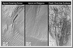
The first picture, "Apron Covering Dunes," shows a deep, prominent martian gully in a south-facing wall in Nirgal Vallis near 29.4°S, 39.1°W. Sunlight illuminates the scene from the upper left. At the bottom of the picture is a series of evenly-spaced, almost parallel ridges. These ridges are dunes created by windblown sand. The apron--the fanlike deposit at the lower end of the deep channel--at this location is seen covering some of the dunes. The sand dunes are thus older than the apron of debris that came from the channel. The dune field has no small meteor impact craters on it, so it, like the gully landforms, is geologically young--yet older than the apron. If the dunes are active in the modern environment--which is uncertain despite the apparent youth of the dunes--then the apron would have had to form within the past few centuries or less. This picture was taken in September 1999.
The second picture, "Apron on Polygons," shows aprons deposited at the base of the south-facing slope in an impact crater at 54.8°S, 342.5°W, in Noachis Terra. The slope and plains surrounding the apron materials have a bumpy pattern of evenly-spaced polygons. Polygonal patterns like this are common in the middle and high latitude regions of Mars, and, like their counterparts in the Arctic and Antarctic regions of Earth, probably form by stresses induced by seasonal and daily freezing and warming cycles of ice in the ground. Such polygons, where found on Earth, are usually only several to tens of thousands of years old, at most. The fact than an apron of debris covers such polygons, and no new polygons have formed on top of the apron, all suggest that the apron--and therefore the gully involved in slope erosion at this location--may be no more than a few tens of thousands of years old, and could be much, much younger. The aprons shown here are from the same July 1999 picture as shown in an accompanying release, "Basic Features of Martian Gullies;" the picture is illuminated from the upper left.
The third picture, "Fresh, Dust-free Surfaces," shows a January 2000
view of small, dark channels eroded into one of the gully alcoves found in
the "Aerobraking Crater" located at 65°S, 15°W. Two aspects of this
picture indicate that two of the processes that contribute to martian gully
formation--liquid water seepage and downslope movement of dry, as well
as wet, debris--have probably occurred in the near-recent past. In this
case, near-recent could mean "within a few days of when the picture was
taken" to "within a few years of when the picture was taken." One
aspect is the sharp contrast between dark-toned and light-toned surfaces
. On Mars, fine, bright dust can settle out of the atmosphere and
eventually coat surfaces so that the contrast between dark and light
terrains is hidden from view. There was an experiment on the Sojourner
Rover in 1997, for example, that found dust to be settling out of the
atmosphere almost all of the time during Mars Pathfinder's 83-day mission.
If dust were settling on the alcoves and small channels shown here, they
would not appear to be so dark relative to the surrounding, bright,
dust-covered terrain. The other attribute of the picture that suggests
relative youth is the preponderance of boulders and their sharp, crisp relief
which indicates that they have not yet broken into finer debris, nor
have they been covered up and mantled by sand or dust. Sunlight
illuminates the scene from the upper right.
(Courtesy NASA/JPL/Malin Space Science Systems)
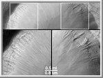 'Dry' Processes on One Slope; 'Wet' Processes on Another
How can martian gullies--thought to be caused in part by seepage and runoff of liquid
water--be distinguished from the more typical, "dry".
(Courtesy NASA/JPL/Malin Space Science Systems)
Views of the Solar System Copyright © 1997-2000 by Calvin J. Hamilton. All rights reserved. Privacy Statement.

 Mars
Mars