NASA SP-441: VIKING ORBITER VIEWS OF
MARS
- CHANNELS -
[31] CHANNELS are among
the more puzzling and intriguing features of the Martian surface. The
most controversial aspect of the channels is whether they were formed
by running water. Present climatic conditions on Mars prevent the
existence of liquid water at the surface, so a water-worn origin
implies that very different climatic conditions prevailed in the
past. A denser atmosphere and higher temperature are both required.
Because of the difficulty in explaining how climatic conditions could
have changed so drastically, alternative methods of erosion, such as
by wind and lava, have been suggested.
Three main types of charmers have been
recognized: (1) runoff channels appear as dendritic networks, or
arrays of relatively small channels or valleys located mainly in the
old, densely cratered terrain; (2) outflow channels appear as large
scale tributaries; and (3) fretted channels appear as long,
relatively wide, fiat-floored valleys that possess tributaries and
increase in size downstream.
Much of the old, cratered terrain,
particularly in the equatorial regions, is dissected by channels of
some type, the most common of which is the simple gully, typically a
few tens of kilometers long. The gullies generally have few
tributaries which, if present, have small junction angles. The
numerous well-integrated tributary networks provide the strongest
evidence for water erosion at some period in Martian history, because
they are unlikely to form by wind action or lava erosion. The runoff
channels are largely restricted to the oldest terrain and are
themselves commonly degraded. Most of these channels therefore appear
to have formed early in the planet's history.
Most outflow channels occur around the Chryse
basin. They commonly emerge full size from chaotic terrain that has
seemingly collapsed to form areas of jostled blocks as many as 3 km
below the surroundings. The channels extend from the chaotic terrain
downslope several hundred kilometers into the plain of Chryse
Planitia. They may be tens of kilometers wide and more than a
kilometer deep, a size indicating erosion on an enormous
scale.
Within the channels are many features, such as
teardrop-shaped islands, longitudinal grooves, terraced margins, and
inner channel cataracts, that are also found in regions on Earth
affected by large floods. The dimensions of the Martian channels
suggest peak flood discharges of 107 to
109
m3/sec. By comparison, the average discharge of the
Amazon is 105 m3/sec, and the largest known terrestrial flood, the Lake
Missoula flood that occurred in eastern Washington in the late
Pleistocene, had a peak discharge of [32] 107 m3/sec. Thus the Chryse
outflow channels, and similar ones elsewhere, provide evidence of
enormous floods on Mars-far greater than any known on Earth.
The time period in which the climatic
conditions permitted liquid water to exist is uncertain because of
the difficulty of precisely dating the channels. Most of the
evidence, however, suggests that the more clement conditions
prevailed very early, perhaps during Mars' first billion years, and
that this period was followed by general global cooling. The present
harsh conditions have probably existed for most of the planet's
history.
Fretted channels occur mostly within the old,
densely cratered terrain, especially at its boundaries with younger
units. They lack features indicative of catastrophic flooding. The
presence of tributaries and a decrease in channel size upstream also
argue against formation by floods. The origin of the fretted channels
is not known, but numerous features on the floors suggest that mass
wasting may have played a significant role.
|
|
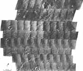
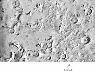
[33] Finely
Channeled Old Cratered Terrain. The channels are concentrated on crater rims
and tend to be approximately parallel, a few tens of
kilometers long, with few tributaries. Such channels are
typical of much of the heavily cratered terrain of Mars, but
are rare in the sparsely cratered areas. [84A16-22;
23°S, 0°W]
|
|
|

|
|
Dendritic Channels in the Southern
Highlands. These channels are
deeply incised with relatively wide, undissected
interfluves. Most terminate abruptly at their lower ends.
[P-18115; 25°S, 10°W]
|
[34]

|
|
Dense Drainage Network in the
Southern Highlands. Dendritic
patterns like these suggest a fluvial origin and argue
against alternatives, such as erosion by wind or lava.
[63A09; 48°S, 98°W]
|
|
|
|
|
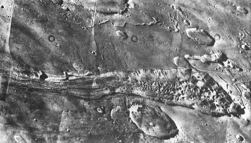
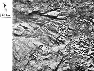
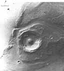
Outflow Channel Emerging from
Chaotic Terrain. Oblique
view, looking south, of the source region of an apparent
flood. The channel starts full scale in a region of chaos
enclosed by cliffs. Possible mechanisms for producing such a
relation are rapid release of water from buried aquifers or
the melting of ground ice by volcanism. [P-16983; 1°S,
43°W]
|
|
|
[35]
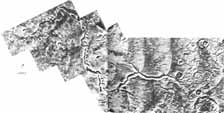
Channels and Chaotic Terrain
at the Source of Tiu Vallis.
A 50 km wide channel emerges from chaotic terrain. It
extends off the picture to the north, down the regional
slope to Chryse Planitia 1000km away. [P19131; 5° S,
29° W]
|
|
|
|
Closeup of Part of Preceding
Image. This frame shows Tiu
Vallis (left) extending northwest from Hydaspis Chaos
(right). Hydapsis Chaos is an elongated area of collapsed
terrain almost 100 km wide, from which emerge the lineated
bedforms and teardrop-shaped islands of Tiu Vallis. [83A37;
3°S, 27°W]
|
|
[36]
|
|
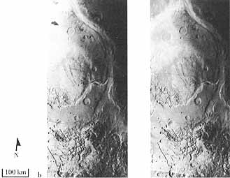
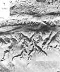
Part of Ares
Vallis. (a) [above] This
mosaic shows part of Ares Vallis incised in the heavily
cratered upland. The channel is 25 km wide and about 1 km
deep. Several layers, probably lava flows, are exposed in
the walls of the channel. Many craters are present in the
upland surface, but craters are few on the channel floor.
(b) [right] A stereogram shows the origin of Ares Vallis in
chaotic terrain. Channels from two large areas of chaos have
merged into a single channel. Where flow from the lower
chaos has merged into the channel, many streamlined forms
are visible. [(a) 211-5238; 10° N, 24° W, (b)
451A03-10; 2° N, 19° W]
|
|
[37]

|
|
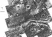
"Islands" near Chryse
Planitia. Teardrop-shaped
"islands" are shown at the mouth of Ares Vallis near the
southern boundary of Chryse Planitia. Flow was from the
south and apparently diverged around obstacles such as
craters and low hills to form a sharp prow upstream and an
elongate tail downstream. A shallow moat surrounds the
entire island. Similar patterns on Earth have been formed by
catastrophic floods, wind erosion, and glacial action. From
top to bottom, the three large craters are named Lod, Bok,
and Gold. [211-4987; 21°N, 31°W]
|
[38]
|
|
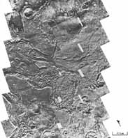
[39]
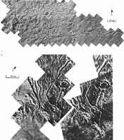
Channels between Lunae Planum
and Chryse Planitia. (a)
Channels have been cut across old cratered terrain between
the lava plains of Lunae Planum on the left and the plains
of Chryse Planitia to the right. Three separate channel
systems are visible, starting from the north: Vedra Vallis,
Maumee Vallis, and Maja Vallis. Flow along the eastern edge
of Lunae Planum converged to cut Maja Vallis. Numerous
teardrop-shaped islands occur upstream of the main channel.
Below the channel to the east (off the right side), the flow
diverges across Chryse Planitia. (b) This stereogram shows
Vedra and Maumee Valles between Lunae Planum and Chryse
Planitia. Note that a branch of Vedra Vallis passes through
Banh Crater. [(a) 211-5190, (b) 211-5419; 18°S,
55°W]
|
|
|

|
|
Upper Reaches of Maja
Vallis. The surface of Lunae
Planum is extremely scoured with long linear grooves and
teardrop islands. Flow apparently converged on Maja Vallis
from a wide area of Lunae Planum. [44A44; 17°S,
57°W]
|
[40]
|
|
Western Chryse
Planitia. The west side of
Chryse Planitia has been extensively sculpted by flow from
Maja Vallis, which is situated just to the left of this
mosaic. Flow diverged across the gently sloping plain of
Chryse Planitia to form the sculpted features seen in this
mosaic. Ridges, similar to those on the lunar maria, appear
to have partly dammed or diverted flow to form a variety of
scour patterns. [211-5015; 21°N, 49°W]
|
|
|
|
[41]
Flow around Dromore Crater in
Chryse Planitia. Flow was
from the left and apparently ponded west of the mare ridge.
It then cut gaps as it flowed over the low points in the
ridge. Similar relations occur in the channeled scablands of
Washington state. After crossing the ridge, the flow cut
grooves in the Chryse Planitia floor as it flowed around
Dromore, an old impact crater. [20A62; 20°N,
49°W]
|
|
|
[42-43]
Bahram Vallis in Northern
Lunae Planum. This channel
has few tributaries, a flat floor, and cuspate walls, and
resembles lunar sinuous rilles that are believed to be
formed by lava flow. [211-5189; 20°N, 57°W]
|
|
[44]
|
|
Section of Valles
Marineris. Each tributary on
the southern wall of the canyon heads in a cirque-like
feature and lacks a fine-scaled drainage network. The
morphology suggests formation by ground water sapping rather
than by surface run-off. Ground ice is a possible source for
the water. [211-5158; 80°S, 85°W]
|
|
|
[45]
|
|
Flat-Floored Valley Northeast of
Hellas. This valley is
several kilometers and is cut into layered deposits that are
clearly exposed in the valley walls. In some places, a
channel is visible in the valley floor. Extensive debris
fans surround many hills in the area and are probably formed
by creeping of near-surface materials, perhaps aided by
interstitial ice. [97A60-68; 43°S, 253°W]
|


