NASA SP-441: VIKING ORBITER VIEWS OF
MARS
- THE
GREAT EQUATORIAL CANYONS -
[17] VALLES MARINERIS is
composed of steep-walled canyons, individually measuring up to 9 km
deep, 250 km wide, and 1000 long. They were named for Mariner 9, the
Mars-orbiting spaces raft that took the first pictures of the canyons
in 1971. The entire Valles Marineris system extends over 4000 km from
west to east near the Martian equator, and its size dwarfs all
similar terrestrial features except, perhaps, the 5000-km-long
midocean rift system.
Pictures taken by the Viking orbiters show
large areas of Valles Marineris at a resolution far better than that
achieved by Mariner 9. The new features observed indicate that,
although erosional landforms (such as landslide scars and deposits)
and tributary canyons are common, faulting apparently has been the
dominant factor in canyon development ..
Since discovery of Valles Marineris, the
method of their formation has been a nagging puzzle. The canyons do
not form a well-integrated d drainage system; some are completely
closed depressions, and lateral transport by wind or water would be
considerably impeded. Now, however, the new evidence of faulting
suggests that most negative relief results from subsidence. Low,
straight scarps, which apparently indicate downward subsidence of
canyon floors along faults, cut across erosional features on many
canyon walls. Similar scale faulting occurs on Earth: in East Africa
the continental crust is in tension across large rift valleys.
Erosion of the Valles Marineris walls apparently continued into the
recent past, so the crustal tension causing the faulting within the
canyons may also have been a relatively recent phenomenon.
Another exciting discovery resulting from
Viking images is the presence e of thick layered deposits on the
floors of several canyons. Layered rock is also visible in the canyon
walls, and thus is part of the Martian crust predating the canyons.
Some materials on the canyon floors are distinctive for the fine
scale and regularity of their layering. Only climatic modulation of a
sedimentary process seems adequate to explain them. Possibly, regular
changes in the Martian climate, governed by known orbital variations,
have controlled the level of dust storm activity and the rate of
deposition of sediment from the atmosphere. Another theory is that
some sections of Valles Marineris were sites of lakes in which
layered sediments were deposited. Before Viking, regularly layered
deposits were known only in the polar regions of Mars, and their
creation may also be associated with cyclical climatic change.
Impact craters, which are so numerous on other
Martian terrains, are scare e within Valles Marineris. They appear
most frequently on smooth areas of canyon floor, and are possibly the
tops of blocks down-faulted from the upland plain. Shallow pits,
possibly eroded impact craters, are abundant in other places. Impact
craters are probably scarce in the canyons because erosion and
deposition by landslides and wind have been actively renewing
interior surfaces. No evidence of flow of water has been found within
Valles Marineris, although some channels on the adjacent upland are
abruptly truncated by steep canyon walls.
|
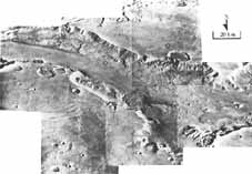
[19]
Global View of the Valles
Marineris. As Viking 1
approached Mars in June, 1976, it recorded this color
picture showing Valles Marineris stretching more than 4000
km across the face of Mars. North is toward the upper right,
and it is the winter season in the southern hemisphere. The
annual southern ice cap extends up to 45°S latitude,
blanketing the Argyre basin, an impact crater 800 km across.
[IPL, ID I 2038MBVI, VERS2; 30°S, 70°W]
|

|
|
|
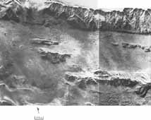
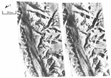
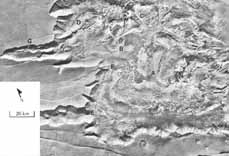
[20]
Western Valles
Marineris. Because these
canyons are poorly linked with one another, and their floors
not a regularly graded slope, they could not have formed as
water drainage features. The straight alignments of many
canyon walls, and the faulting in several directions
associated with Noctis Labyrinthus, combine to suggest that
the Valles Marineris system is composed of great rift
valleys formed on the surface of a dome. At the summit of
the dome, near the labyrinth, the crust was stretched in all
directions to form a network of fault-bounded valleys. On
the flanks of the dome, the greatest strains were concentric
about the summit, giving rise to a set of radial rift
valleys. The inset shows names of individual canyons
(chasma). [40A37-52; 13° S, 87° W]
|
|
[21]
Eastern Valles
Marineris. The broadest
valleys merge with patches of chaotic terrain, apparently
the product of collapse and erosion of ancient cratered
terrain. Channels beginning at the margins of chaotic
terrain extend northeastward onto Chryse Planitia, the
region in which Viking Lander 1 is located. The relationship
between Valles Marineris and the chaos is not well
understood. Irregular collapse, to form the chaos, may
reflect crustal stresses similar to those forming the rift
valleys, but differing in orientation and complexity. It is
also possible that the chaos formed during the catastrophic
release of liquid water derived from artesian reservoirs or
the melting of ground ice. [32A11-15; 9°S, 53°
W]
|
|
|
|
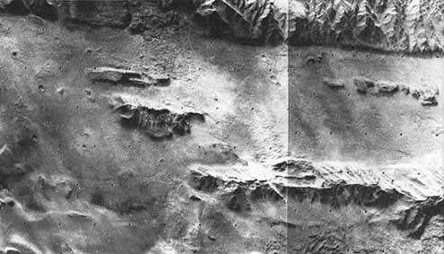
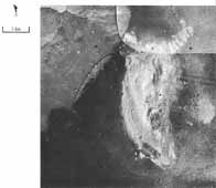
[22]
View of Coprates Chasma
Looking East-Southeast.
Interplay of faulting and erosion within Valles Marineris is
apparent here. A low, steep, and generally straight scarp
occurs at the foot of the north canyon wall. The scarp
apparently results from downward offset of the flat canyon
floor relative to the wall. Gullies on the canyon wall are
truncated by the scarp and thus predate it. In contrast,
large-scale landsliding from two great canyon wall alcoves
postdates the latest down-faulting; landslide debris has
buried the scarp for a distance of about 40 km. [58A89-91;
15° S, 60° W]
|
|
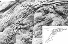
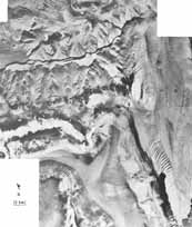
[23]
Evolution of Canyons by
Landsliding. This mosaic of
Viking Orbiter 1 pictures was taken looking southward toward
the junction of Gangis and Capri Chasmae. Rugged d terrain
consisting of numerous tilted blocks occurs within alcoves
in the can! on wall. Extending from the alcoves are thin
blankets of material with fan-like patterns of surface
striations. Where two patterns intersect, one thin lobe
clearly overlies the other and cuts off its striations.
These features are giant landslide deposits that formed when
sections of canyon rim collapsed. The broad thin lobes of
material apparently flowed at high velocity from the bases
of the collapsing masses. The mechanism by which the surface
striations formed is not well understood. although similar
features have been observed on terrestrial landslides.
Groups of hills, similar to chaotic terrain, and sand dunes
contribute to a varied canyon floor landscape. Layering in
the upland rocks is evident near the top of the south canyon
wall within the landslide alcoves. [14A29-32; 9°S,
42°W]
|
|
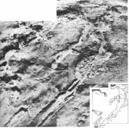
|
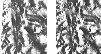
Stereogram of Ius Chasma. The south can! canyon wall here is incised
by several large, branching tributary canyons that appear to
have developed headward along joints or zones of weakness in
upland rocks. It has been suggested that these canyons
developed through a sapping process, in which the melting of
ground ice caused the upland to collapse. The floor of the
main canyon between A and B appears to have been fractured
and down faulted below the level of the mouths of the
tributary canyons. Layering can be seen in several places on
the canyon walls (C and D ). [Left 66A07-09, Right 63A40:
7°S, 85°W]
|
|
|
|
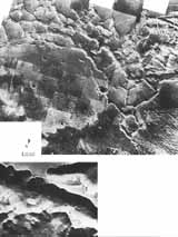
[24]
Noctis Labyrinthus
[left]. The origin of
the canyon by faulting is most apparent in Noctis
Labyrinthus at the western end of Valles Marineris. Many
canyons have a classic graben form, with the upland plain
surface preserved on the valley floor. Other canyons are
more irregular in form and have rough floor terrains,
evidently the consequence of landsliding and the puzzling
process of pit formation. In places it appears that surface
materials have sifted downward into a gaping hole in the
subsurface. The inset shows a slope covered with light
albedo dunes and several small landslide lobes. [46A13-28,
47A17-28, 48A21-28, 49A22-28, 50A14-28, Inset 62A64;
7°S, 100°W]
|
|
|
|
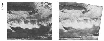
[25]
Stereogram of Central
Tithonium Chasma [below].
This section of Tithonium Chasma is about 6 km deep.
Overlapping landslide lobes cover the canyon floor and
scarps that bound a rift valley within the canyon. On the
south canyon wall, distinct bright and dark horizontal
stripes are probably outcrops of layered rocks. Parallel
chains of pits and graben mark the upland surface to the
south. [Left 57A45, Right 64A22; 5°S, 85°W]
|
|
|
|
[26]
Large Albedo Contrasts and
Relief in Tithonium Chasma.
Large contrasts in the brightness of surface materials can
so confuse perception of depth in single frames that
stereoscopic imaging is necessary to interpret surface
features To the left is a long, narrow rift valley about 5
km deep. North of this valley the canyon floor is 1 to 2 km
higher and irregularly mottled. A mountain with finely
gullied flanks rises about 2 km from the canyon floor. This
mountain is representative of many plateaus, ridges, and
hills on the floors of broader canyons. They differ
drastically from canyon wall materials in their patterns of
erosion. Many are composed of materials with a distinct
horizontal layering. [Left 44A27, Right 63A63; 5°S,
65°W]
|
|
|
|
West Candor Chasma. Here the canyon floor is entirely covered
with eroded, layered materials. Layering is most prominent
at A, B and C. An offset spur (D) and a low, steep scarp
(EF) along the western walls of the canyon may have been
formed by faults trending north to south across the main
Valles Marineris. The tributary canyon at G seems to have
developed by two processes; subsidence of a block of crust
(graben), and irregular collapse into a string of pits.
[65A25, 57; 66A17-27; 7°S, 75°W]
|
|
|
|
[27]
Candor and Ophir
Chasmae. Large plateaus (A,
B), formed at least in part of regularly layered materials
(as at A), rise from the floor of Candor and extend across
the gap between Candor and Ophir Chasmae. At C, plateau
materials apparently were deposited upon an eroded spur of
the canyon wall and are now themselves being eroded away.
Streamlines ridges and grooves in Ophir Chasma are probably
wind sculpted. [66A23-30; 5° S, 73° W]
|

|
|
[28]
Plateaus between Ophir Chasma
and Candor Chasma. These
enormous, streamlined plateaus bridge the gap between the
two canyons, possibly indicating wind erosion on a very
large scale. Alternately, it has been suggested that a lake
(or sea) once existed in the north section of Ophir Chasma
until the canyon wall was breached southward to unleash an
enormous flood. The dark material on the canyon floors is
probably a wind deposit, as dune-like forms are visible in
other images. [IPL ID, IV2515CGX2, I2515DGX2; 5°S,
73°W]
|
|
|
|
[29]
Layered Material in Juventae
Chasma. A ridge of very
uniformly layered light and dark materials rises from the
floor of Juventae Chasma. Cyclical changes in sedimentation,
perhaps modulated by climate, seem the most probable
explanation for their origin. [85A15-17; 5°S,
62°W]
|
|


