|
|
[23] Viking was a project in which nothing was left to chance. At the time of launch, the computers on board the Lander were programmed to carry out a complete sequence of scientific analyses on the surface of Mars, in the unlikely event that the receivers onboard the Lander failed and we were unable to provide further instructions.
Consistent with this requirement, we programmed a series of particular pictures to be taken over a 60-sol period (a sol is a martian day of 24 hr and 40 min). Hundreds of hours were spent in this elusive exercise how do you best arrange pictures to document a landscape that you've never seen?
We paid little attention to the preprogrammed pictures scheduled late in the mission, but the first two pictures were planned with care. In the latter case, the preprogrammed images would be the ones actually acquired. Because the first picture was initiated 25 sec after landing-and the second picture immediately after that-there would be no opportunity for a change of mind after landing. In any event, the first picture was, by definition, one that could not benefit from prior knowledge of the scene.
The planning for these first two frames was exhaustive. Everyone volunteered advice. More than a year before the landing, we were summoned to Washington to brief Dr. James Fletcher, NASA administrator, on our camera strategy. The reason for this unusual attention was obvious. In the event of a botched landing, the first two images might constitute our only pictorial record of Mars. The pictures would be transmitted to the Orbiter in the first 15 min after landing, and thence back to Earth. Not for 19 hr-including the passage of a first night on Mars-would it be possible to communicate again with the Lander.
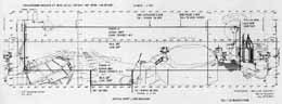
The first preprogrammed image was a high-resolution view of the area adjacent to the footpad, the second a low-resolution panorama covering most of the viewing area accessible to the one camera (fig. 19). A number of our colleagues challenged the priorities- "If you were transported to an unknown terrain, would you first look down at your feet?" Indeed, in a common mental image, the explorer shades his eyes, looking far away to the distant horizon. Our counter argument was relatively pedestrian. A primary photogeologic goal, perhaps because it is so easily quantifiable, is increase in linear resolution. Looking nearly straight down, the slant range was about 2 m, yielding a linear resolution of approximately 2 or 3 mm. Looking toward the horizon, nominally 3 km distant, the linear resolution would be reduced by three orders of magnitude.
Our logic would have been persuasive if the surface of Mars had been generally flat, but covered with small objects of unusual form. As it turned out, this was not the case. The rock-littered surface in the near field is relatively undistinguished, but the undulating topography and diverse geology of the middle and far field is spectacular. From both an exploratory and scientific perspective, the panorama to the horizon is the more impressive of the first two pictures.