 Figure 136
|
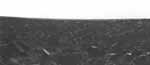
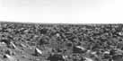
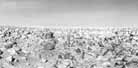
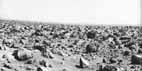
[114-115] This
panorama of almost 100°, looking toward the east, is
broken into two segments, figures 136 and 137. In figure 136
a sequence of increasingly distant ridges can be identified.
In the right half of figure 137 a block studded crest close
to the spacecraft obscures the distant horizon. The general
slope of the horizon is a consequence of spacecraft tilt,
not of any natural gradient in the scene. Indeed, the
horizon is almost exactly level, displaying significantly
less relief than the distant landscape at the Viking 1 site.
By coincidence the farthest horizon appears at the lowest
point in the tilted image.
The origin of this gently undulating
plain at the Viking 2 site is a matter of conjecture, but a
likely possibility is that the Lander is situated on a vast
ejecta deposit associated with a 100 km crater, Mie,
situated 160 km to the east. Eolian deflation might have
stripped much of the fine grained material originally in the
ejecta deposit. Unfortunately, no landforms in the Lander
camera images are identifiable in Orbiter images.
|