
Courtesy of the Jet Propulsion Laboratory and NASA's National Space Science Data Center
The Magellan spacecraft was the first planetary explorer to be launched by a space shuttle when it was carried aloft by the shuttle Atlantis from Kennedy Space Center in Florida on May 4, 1989. Atlantis took Magellan into low Earth orbit, where it was released from the shuttle's cargo bay and fired by a solid-fuel motor called the Inertial Upper Stage (IUS) on its way to Venus. Magellan looped around the Sun one-and-a-half times before arriving at Venus on August 10, 1990. A solid-fuel motor on the spacecraft then fired, placing Magellan into a near-polar elliptical orbit around Venus.
The spacecraft carried a sophisticated imaging radar, which was used to make the most highly detailed map of Venus ever captured during its four years in orbit around Venus from 1990 to 1994. After concluding its radar mapping, Magellan also made global maps of Venus's gravity field. Flight controllers then tested a new maneuvering technique called aerobraking, which uses a planet's atmosphere to slow or steer a spacecraft. The spacecraft made a dramatic plunge into the thick, hot Venusian atmosphere on October 12, 1994, and was crushed by the pressure of Venus's atmosphere. Magellan's signal was lost at 10:02 Universal Time (3:02 a.m. Pacific Daylight Time) that day.
The Magellan mission was divided up into "cycles" with each cycle lasting 243 days (the time necessary for Venus to rotate once under the Magellan orbit). The mission proceeded as follows:
04 May 1989  -  Launch
10 Aug 1990  -  Venus orbit insertion and spacecraft checkout
15 Sep 1990  -  Cycle 1:  Radar mapping (left-looking)
15 May 1991  -  Cycle 2:  Radar mapping (right-looking)
15 Jan 1992  -  Cycle 3:  Radar mapping (left-looking)
14 Sep 1992  -  Cycle 4:  Gravity data acquisition
24 May 1993  -  Aerobraking to circular orbit
03 Aug 1993  -  Cycle 5:  Gravity data acquisition
30 Aug 1994  -  Windmill experiment
12 Oct 1994  -  Loss of radio signal
13 Oct 1994  -  Loss of spacecraft
In all, the highly successful imaging radar mapped more than 98 percent of the planet's surface and collected high-resolution gravity data of Venus. The lessons learned from Magellan's aerodynamic dive into the Venusian atmosphere will be applied to future planetary missions.
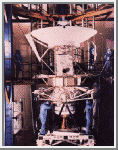 Magellan Assembly
On May 4, 1989, the Magellan spacecraft was deployed from the
shuttle. The spacecraft is topped by a 3.7-meter (12-foot) diameter
dish-shaped antenna that was a spare part left over from the Voyager
program. The long, white, horn-shaped antenna, attached just to the
left of the dish antenna, is the altimeter antenna that gathers data
concerning the surface height of features on Venus. Most of the
spacecraft is wrapped in reflective white thermal blankets that protect
its sensitive instruments from solar radiation.
(Courtesy NASA/JPL)
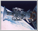 Deployment
The Magellan spacecraft's deployment from the shuttle Atlantis' cargo
bay was captured by an astronaut with a hand-held camera pointed
through the shuttle's aft flight deck windows. Deployment occurred in
the early evening of May 4, 1989, after Atlantis had carried Magellan
and its Inertial Upper Stage (IUS) booster rocket, into low Earth
orbit. Once the shuttle was safely away from the spacecraft, the IUS
ignited and placed Magellan on course for its 15-month journey to
Venus.
(Courtesy NASA/JPL)
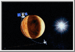
Magellan Orbiting Venus
On August 10, 1990, Magellan entered into orbit about Venus, as
depicted in this artist's view. During its 243-day primary mission,
referred to as Cycle 1, the spacecraft mapped well over 80 percent of
the planet with its high-resolution Synthetic Aperture Radar (SAR). The
spacecraft returned more digital data in the first cycle than all
previous U.S. planetary missions combined.
(Courtesy NASA/JPL)
 Magellan Mapping Venus
The sequence of events that comprise a Magellan mapping orbit are shown
in this artist's conception. For the first 37.2 minutes of each orbit,
the Synthetic Aperture Radar measures and records a 20-kilometer
(12-mile) wide swath of the planet's surface. When Magellan reaches the
high point of its orbit, the spacecraft turns its antenna toward Earth
and transmits the data. After 113.8 minutes of transmitting, the antenna
is repositioned for another orbit about Venus.
(Courtesy NASA/JPL)

 Space History