NASA SP-441: VIKING ORBITER VIEWS OF
MARS
- VOLCANIC FEATURES -
[47] VOLCANIC ACTIVITY on
Earth can be divided into two basic types: eruptions that occur
repeatedly from the same conduit and slowly build roughly circular
mountains, and eruptions from any widely spaced vents, usually
fissures, that create extensive lava plains. Both types are found on
Mars. Volcanic rocks are of particular interest to the geologist
because they originate deep within the planet and provide a means of
assessing the conditions and processes that operate there. Although
we are unable to examine the rocks on Mars directly, the volcanic
features give an indication of rock composition. For example,
silica-rich lavas tend to have higher viscosities and yield strengths
than silica-poor lavas and so form differently shaped flows;
volatile-rich, viscous lavas tend to produce abundant ash during
eruptions, so ash deposits rather than lava flows are the predominant
landform. The volcanoes are also interesting in that their shapes and
sizes provide information on thermal conditions in the interior of
the planet. The volcano height gives a means of estimating the depth
of melting, and the degree of sagging of the crust under the weight
of the volcano permits the viscosities of the crustal materials and
hence the temperature profile to be calculated.
Martian volcanoes are most common in the
region of Tharsis, where three large volcanoes (Ascreus Mons, Pavonis
Mons, and Arsia Mons) form a northeast-southwest line. Another large
volcano, Olympus Mons, is located about 1500 km northwest of the
line. All four are enormous by terrestrial standards. Olympus Mons is
more than 600 km across and towers approximately 27 km above the mean
surface level. Alba Patera, just to the north of Tharsis, although
only a few kilometers high, is 1700 km in diameter. The Hawaiian
volcanoes, which are among the largest on Earth, are generally less
than 120 km in diameter and 9 km above the ocean floor. Surrounding
the massive Martian volcanoes are extensive lava plains and many
smaller volcanoes such as Biblis Patera and Tharsis 'Tholus.
Volcanoes occur in regions of the planet other than Tharsis, but tend
to be smaller and older.
Each of the three Tharsis shield volcanoes has
a caldera complex at its summit, apparently formed by repeated
collapses following eruptions. On the flank of each edifice is a
faint radial texture formed by numerous long, thin flows, some with
central channels. The general morphology of the flows is similar to
those on the flanks of the Hawaiian shield volcanoes and suggests
fluid flow. Various concentric features such as terraces, breaks in
slope, and lines of rimless depressions are superposed on the radial
texture. On the northeast and southwest sides of each volcano,
numerous pits in the shield coalesce to form alcoves that evidently
were sources of enormous [48] volumes of lava.
Flows spread from these alcoves over the adjacent plains, covering
the lower flanks of the volcanoes and extending several hundred
kilometers from the source. Thus, eruptions from the Tharsis
volcanoes formed d both the volcanic edifices and the surrounding
plains.
The main edifice of Olympus Mons resembles the
Tharsis shields except that it is surrounded by a cliff that, at some
points, reaches 6 km in height. In several places, lava has flowed
over the cliff and across the surrounding plains, extending the
volcanic edifice beyond the scarp. All around Olympus Mons, blocks of
strongly ridged terrain extend as far as 1000 km from the scarp and
constitute the so-called aureole. The origin of the aureole is
unclear, but suggestions are that it is the remnant of a pre-Olympus
volcano, that it consists of eroded ash-flow tuffs, or vast thrust
sheets.
Alba Patera, just to the north of Tharsis,
differs from the volcanoes already described. Although it is more
than 1700 km across, it is only about 2 km high. Many flow features
are visible on its flanks. These features are often as many as 10
times larger than their terrestrial counterparts, but otherwise show
great similarity. The nature of Alba Patera's flow features again
suggests fluid lavas.
Relatively featureless plains cover much of
the planet's surface. The origins of most of the plains are not
known. Although some may be largely aeolian and fluvial, evidence
indicates that most are volcanic. The plains around the larger
volcanoes have numerous flow features and are almost certainly
volcanic. Other plains have ridges and rille-like features that
resemble those on the Moon and so are suspected of being volcanic
like the lunar maria. Where visible in section, the plains are
layered, perhaps indicating interbedded materials of different
origins.
|
|
[49]
(a) 
|
(b) 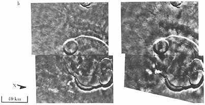
|
|
|
|
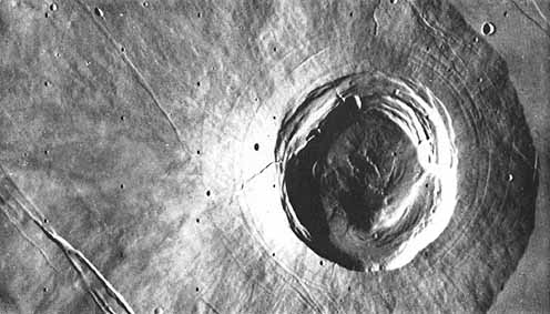
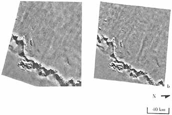
Olympus Mons. (a) This volcano, the largest on Mars,
measures over 600 km across at the base, and is about 27 km
high. It is surrounded by a well-defined scarp that is up to
6 km high. Flows drape over the scarp and extend onto tile
surrounding plains. [n many places the scarp is associated
with small block faults, indicating that faulting may, have
played a part in its development. Parts of the plains
surrounding tile volcano are characterized by ridged and
grooved terrain that is faulted in places. The origin of
this terrain is not known. (b) The stereogram permits a
greater appreciation of the structure of Olympus Mons,
especially the caldera and the scarp. [(a) 211-5360, (b)
Left 211-5345. Right 211-5360: 18° N, 133°
W]
|
[50]
|
|
Summit Caldera of Olympus
Mons. This mosaic consists of
several frames that show features on the surface as small as
18 meters across. The circular caldera on the left is almost
3 km deep and 25 km across and has wall slopes of about
32°. It probably formed as a result of recurrent
collapse following drainage of magma out of the central
conduit of the volcano during flank eruptions. The floor of
the deepest caldera is featureless at this resolution, but
the floor materials of other parts of the caldera complex
are marked by fault patterns and ridges similar to mare
ridges on the Moon. Fluting of the caldera walls suggests
landslide activity. [211-5601: 18°N 133°W]
|
|
|
|
Terraces on Upper Slopes of
Olympus Mons. The origin of
the lava terraces is not known. In some respects they are
analogous to terraced features seen on pahoehoe flows on
Mount Etna Sicily , where they formed as a result of
embankments developing at the fronts of lava flows and the
accumulation of lava lakes behind the embankments. Some of
the small craters appear to be rimless volcanic pits.
[46B12; 17° N 132° W ]
|
|
[51]

|
|
Lava Flow Drapes over Olympus Mons
Scarp. (a) Lava channels and
partially collapsed lava tubes are visible along the crests
of ridge-like flows. The surface features on these flows are
similar to those developed on basaltic flows on Earth.
Clearly the scarp in this area is older than the flows
indicating that at least the youngest flows on the mountain
occurred d after scarp formation. In this region the Olympus
Mons flows make up the plains surface at the foot of the
scarp. However, in other areas Olympus Mons flows have been
overlain by the smooth-surfaced material of the plains. (b)
The stereographic pair graphically portrays the ruggedness
of the scarp. [(a) 47B25 (b) Left 46B34, Right 45B45;
21°N 130° W]
|
|
[52]
|
|
Arsia Mons. The summit is at about the same elevation as
that of Olympus Mons rising 16 km above the Tharsis Ridge
itself about 11 km high. The caldera is less complex than
that of Olympus Mons being a single, large circular
structure about 140 km in diameter. Surrounding the caldera
are concentric graben; the main northeast-southwest trending
fracture zone underlying the volcano is indicated by
numerous collapse pits seen here on the upper side of the
caldera. This mosaic shows an enormous flow-like feature
that extends from the volcano flanks onto the adjacent
plains and which consists of hummocky terrain with faint
concentric features. The flow terminates in fine scale
ridges parallel to the flow's front edge. The origin of this
feature is not clear but it may be a major landslide that
developed high on the flanks of the volcano at a time when
the volcano slopes were unstable. The concentric ridges in
the distal parts appear to run through all the topographic
features without substantially modifying them. and may be
pressure ridges that developed in the underlying terrain at
the foot of the unit. [211-5317; 9°S, 123
°W]
|
|
|
|
|
[53]
Possible Landslide Deposit on
Arsia Mons. Hummocky terrain
makes up most of this flow, and grades into the finely
ridged, concentric flow front. These features may be
pressure ridges at the front of the flow or, in some places
deceleration ridges formed as the flow came to a standstill.
Small lava flow fronts are visible on the smooth plains in
front of the main flow. [49B89; 3°N 117°W]
|

|
[54]

|
|
Extensive Lava Flows from Arsia
Mons. The flows that erupted
from Arsia Mons extend some 1500 km away from the summit and
bury the older cratered terrain of the southern hemisphere.
Flow fronts are visible within the large crater Pickering
(120-km-diameter) where they have been diverted around high
ground associated with the central peak of the crater. Flows
of this type associated with the big volcanoes may have
lengths in excess of 1000 km and may resemble the large
flows found in Mare Imbrium on the Moon. The discovery of
these flows on the outer flanks of the major volcanoes on
Mars has shown that the basal diameter of many of these
volcanoes is considerably larger than was suspected from
Mariner 9 data. [56A12; 34°S 133°W]
|
[55]
|
|
Arsia Mons Summit. Part of the caldera is visible at the upper
left of' the picture. The summit of the volcano is cut by
lines of pits marking the fracture zone running through the
volcano. Most of the lava at the middle and bottom right of
the picture appears to have originated from the fracture
zone, and postdates the summit cone of the volcano. A well-
defined channel/tribe system is visible toward the lower
right of the picture pits at the head of this channel system
represent the vent area. [52AO4; 12°S,
120°W]
|
|
|
|
Summit of Alba
Patera. This volcano is only
a few kilometers above the surrounding plain which coupled
with its large diameter of some 1700 km gives it a much
lower profile than the Tharsis volcanoes. The rim of an old
caldera near the summit partly buried by younger lava flows
is visible at the bottom left; at the bottom right a younger
caldera is at the top of the youngest summit cone. Lava
flows are well preserved and flows can be seen extending
from near the lower right of the picture toward the upper
left. [7B94; 41°N, 109°W]
|

|

|
|
[56]
Lava-Covered Upper Flanks of
Alba Patera. Different kinds
of flows are visible. Large, relatively feat-topped flows
with well-defined flow fronts occur in the middle of the
frame. At the lower left are long flow-ridges, some of which
extend for several hundred kilometers. The flat-topped flows
are generally considered to have been fed by lava tubes. One
flow has a sinuous channel-tube running along the crest of
the ridge. Superposed impact craters on Alba Patera are more
numerous than on Olympus Mons and Arsia Mons suggesting an
older age for many of these flows. [7B24; 48°N,
115°W]
|
[57]

|
|
Ridge-Like Lava Flows on Alba
Patera. This part of the
flanks of Alba Patera has ridge-like lava flows with
complicated dendritic patterns developed on them. Some of
these channels may be directly associated with the formation
of the lava flows, but some may have resulted from fluvial
modification of the volcano flanks. Cutting the lava flows
in this area is a well-defined graben, within which are
numerous collapse pits. [7B53; 46°N, 119°W]
|
|
|
|
Biblis Patera. This volcano, situated between Arsia Mons
and Olympus Mons, is much smaller than those so far
described. Flow features on the flanks of the volcano are
truncated by the surrounding plains, indicating partial
burial by later deposits. The exposed part of the volcano
has a basal diameter of about 100 km. Its original size may
have been larger, although, from the small size of the
caldera, it is unlikely-eve n considering the buried
base-that it was ever as large as the giant Tharsis
volcanoes. The summit caldera is surrounded by almost
circular faults, which seems characteristic of Martian
volcanoes. [44B50; 3°N, 124°W]
|

|
[58]

|
Ulysses Patera. This volcano lies just to the east of Biblis
Patera in the northwest part of 'Tharsis. It is similar in
size to Biblis Patera, is surrounded by younger flows, and
has two superposed craters, probably of impact origin. These
craters are older than the surrounding plains, and they have
intersected the caldera walls and pushed material into the
floor of the caldera. [49B85; 3°N, 121°W]
|
|
|

|
Tharsis Tholus. This 17O-km diameter volcano differs in form
from the volcanoes previously illustrated. The caldera has a
wide bench around one side. This bench may represent an
early lava lake level before further collapse occurred in
the middle of the caldera. Scarps intersecting the caldera
appear to be normal faults rather than graben. The base of
the volcano is covered by younger materials so its original
size cannot be determined. [225A13; 13°N,
92°W]
|
[59]
|
|
Tyrrhena Patera. The flanks of this ancient, southern
hemisphere volcano have been strongly modified and embayed.
At the summit is an irregular depression that is continuous
with a valley, extending down the outer flanks. Concentric
graben surround the summit. The volcano is so degraded that
there are no well-defined primary volcanic depositional
features to provide clues regarding the nature of the
erupted materials. However, the low profile of the volcano,
and the way in which outliers of the volcano form mesa-like
bodies, suggest ash flow deposits rather than lavas.
[211-5730; 20°S, 252° W]
|
[60]

|
|
Hadriaca Patera. This volcano's caldera is much
better defined than that of Tyrrhena Patera, but its flanks
are strongly degraded by radial valleys. The volcano is
younger than many of the surrounding craters, but still much
older than the Tharsis volcanoes, as indicated by the
numbers of superposed impact craters. [97A42; 30°S,
270°W]
|
[61]

|
|
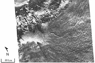
Volcano-Like Features in the Chryse Basin. In the
upper left of this picture, a light circular feature with a
central pit and a very low profile straddles a sinuous line,
which may be the trace of a dike or fracture. The feature is
less than 10 km across, much smaller than any of the other
volcanoes described. [4A36; 18°N, 35°W]
|


