|
|
[3] PROJECT VIKING was begun by the National Aeronautics and Space Administration on November 15, 1968. The main objectives of the project were to achieve a soft landing on the surface of Mars and to relay scientific data back to Earth. Scientific goals for the mission were established in response to recommendations of the Space Science Board, a NASA advisory panel. Foremost among their recommendations was that the first Mars lander mission should emphasize life detection experiments to answer the question about the possibility of life on the planet. In consideration of these goals and the everpresent constraints of funds and spacecraft capability, the following investigations and associated instruments were established:
|
Investigations |
Instruments |
|
| |
|
Orbiter imaging |
Two vidicon cameras |
|
Water vapor mapping |
Infrared spectrometer |
|
Thermal mapping |
Infrared radiometer |
|
Entry science | |
|
Ionospheric properties |
Retarding potential analyzer |
|
Atmospheric composition |
Mass spectrometer |
|
Atmospheric structure |
Pressure, temperature and acceleration sensors |
|
Lander imaging |
Two facsimile cameras |
|
Biological analyses |
Three separate experiments, gas exchange, labelled release, and pyrolytic release, were included to test different biologic models. |
|
Metabolism | |
|
Growth | |
|
Photosynthesis | |
|
Molecular analysis |
Gas chromatograph mass spectrometer |
|
Organic compounds | |
|
Atmospheric composition |
Mass spectrometer |
|
Inorganic analysis |
X-ray fluorescence spectrometer |
|
Meteorology |
Pressure, temperature, and wind velocity sensors |
|
Seismology |
Three-axis seismometer |
|
Magnetic properties |
Magnets on sampler and a camera test chart, observed by cameras |
|
Physical properties |
Various engineering sensors |
|
Radio science |
|
|
Celestial mechanics |
Orbiter and lander radio and radar systems |
|
Atmospheric properties | |
|
Test of general relativity | |
[4] The main functions of the orbiter cameras, whose pictures are displayed in this book, were to aid in the selection of safe, landing sites, to establish the geologic and dynamic environments in which the lander experiments were performed, and to add to our knowledge of the evolution of the Martian surface and the dynamics of its atmosphere.
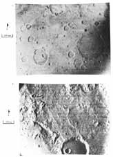
Mariner 4, launched in 1964, weighed only 262 kg and carried only a small science payload. As it flew by Mars at a minimum range of slightly less than 10 000 km, it returned 21 pictures of the planet. An airbrush mosaic of two of the better Mariner 4 frames is shown here. The resolution is approximately one kilometer, about 150 times better than Earth-based photographs. The pictures show a cratered surface that superficially resembles the Moon, a result that was somewhat disappointing in view of some of the more extreme expectations. Certainly, no canals were observed.
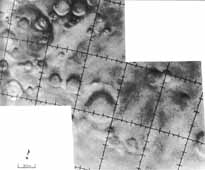
In 1969, twin spacecraft, Mariner 6 and Mariner 7, were sent to examine Mars. Like Mariner 4, these spacecraft were flybys, and between them they acquired 201 images that were a blend of low-resolution, wide- area frames and nested, high-resolution frames. A typical image pair is shown in the frames taken south of Sinus Sabaeus. The highest resolution achieved was approximately 500 meters. Again, most of the area photographed resembled the Moon, and craters dominated the landscape. Only a few pictures displayed nonlunar-like features, such as chaotic and featureless terrains, that might have hinted at what remained to be discovered. In fact, the two spacecraft had passed over only those parts of the planet that retain an ancient cratered surface, and they had missed the parts of the planet that have younger and more diverse geological features.
Mariner 9, the final predecessor to Viking, eventually revealed the extraordinary diversity of the planet's surface. Arriving at Mars in November 1971, Mariner 9 was the first spacecraft to go into orbit about another planet. It took more than 7300 images of Mars, covered the entire surface at a resolution ranging from 1 to 3 km, and covered selected areas at resolutions down to 100 meters. The typical Mariner 9 image included here was taken in the same area as the Mariner 4 images. Mariner 9 operated for almost a year, nearly four times the minimum mission requirement, before running out of attitude control gas. Along with the images, extensive data were obtained on the atmosphere, surface temperature, and global weather patterns.
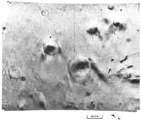
The images from Mariner 9 were the most exciting ever obtained in planetary exploration, revealing giant canyons and volcanoes, large channels (possibly cut by liquid water), and puzzling features that defied all geological < explanations. The stage was set for the Viking missions.
Viking 1 was launched from Kennedy Space Center at Cape Canaveral on August 20, 1975, and arrived at Mars on June 19, 1976. Initially, the spacecraft was put into a Mars-synchronous elliptical orbit with a period of 24.66 hours, an apoapsis of 33 000 km, and a periapsis of 1513 km. During the first month, Viking 1 was used exclusively to search for and certify a safe landing site for Viking Lander 1. After the lander touched down on Mars on [5] July 20, 1976, (the seventh anniversary of the first manned lunar landing) the orbiter began systematically imaging the surface. Its highly elliptical orbit was particularly suited for studying the surface because it allowed a mix of close-up, detailed views at periapsis and long-range, synoptic views near or at apoapsis.
Table 1 is a chronology of the orbit of Viking Orbiter 1. Two events merit further description. On February 12, 1977, the orbit was changed to permit a flyby of Phobos, the larger, inner Martian moon. At closest approach, the orbiter flew within 90 km of the surface of Phobos. On March 11, 1977, the periapsis of Viking Orbiter 1 was lowered to 300 km from the Martian surface. At this low periapsis, surface features as small as 20 meters across could be identified, while the ability to acquire lower resolution and greater areal coverage away from periapsis was retained. At the beginning of this decade, Viking Orbiter l had taken more than 30 000 pictures of the planet and was still operational.
|
| ||
|
| ||
|
|
|
|
|
| ||
|
June 19 1976 |
|
Mars orbit insertion |
|
June 21, 1976 |
|
Trim to planned site-certification orbit |
|
July 9, 1976 |
|
Orbit trim to move westward |
|
July 14, 1976 |
|
Synchronous orbit over landing site |
|
July 20, 1976 |
|
VL-1 landing et 1153:06 UTC. |
|
Aug. 3, 1976 |
|
Minor orbit trim to maintain synchronization over VL-1 |
|
Sept. 3, 1976 |
|
VL-2 landing |
|
Sept. 11, 1976 |
|
Decrease of orbit period to begin eastward walk |
|
Sept. 20, 1976 |
|
Orbit trim to permit synchronization over VL-2 |
|
Sept. 24, 1976 |
|
Synchronous orbit over VL-2 |
|
Jan. 22, 1977 |
|
Period change to approach Phobos |
|
Feb. 4, 1977 |
|
Orbit synchronization with Phobos period |
|
Feb. 12, 1977 |
|
Precise correction to Phobos synchronization |
|
March 11, 1977 |
|
Reduction of periapsis to 300 km |
|
March 24, 1977 |
|
Adjustment of orbit period to 23.5 hours |
|
May 15, 1977 |
|
Small Phobos-avoidance maneuver |
|
July 1, 1977 |
|
Adjustment of orbit period to 24.0 hours |
|
Dec 2, 1978 |
|
Adjustment of orbit period to 24.85 hours: beginning slow walk around planet |
|
May 19, 1978 |
|
Adjustment of orbit period to 25.0 hours: acceleration of walk rate |
|
July 20,1979 |
|
Raising of periapsis to 357 km; adjustment of orbit period to 24.8 hours: and slowing of walk rate |
[6] Viking 2 was launched September 9, 1975, and arrived at Mars on August 7, 1976. Like its predecessor, Viking 2 spent nearly a month after arrival finding and certifying a landing site for its lander. Table 2 is a chronology of Viking Orbiter 2. A major difference in the orbit of this spacecraft compared to that of Viking Orbiter 1 is its high inclination, which allowed Viking Orbiter 2 to observe the complex, enigmatic polar regions at relatively close range. Later in its mission, Viking Orbiter 2 flew by Deimos, the smaller of the two Martian moons, at a distance of only 22 km. Spectacular pictures allowing features as small as a compact car were taken. Viking Orbiter 2 returned nearly 16 000 pictures of Mars and its satellites before it was powered down on July 25, 1978.
|
| ||
|
| ||
|
|
|
|
|
| ||
|
Aug. 7, 1976 |
|
Mars orbit insertion |
|
Aug. 9, 1976 |
|
Period and altitude adjustment; beginning of westward walk |
|
Aug. 14, 1976 |
|
Increase of period to increase walk rate |
|
Aug. 25, 1976 |
|
Decrease of walk rate to proceed to landing site |
|
Aug. 27, 1976 |
|
Synchronous orbit over landing site |
|
Sept. 3, 1976 |
|
VL-2 landing at 2237:50 UTC |
|
Sept. 30, 1976 |
|
Change of orbit plane to 75° inclination and beginning of westward walk |
|
Dec. 20, 1976 |
|
Lowering of periapsis to 800 km and increasing of inclination to 80 |
|
March 2, 1977 |
|
Synchronous orbit over VL-2 |
|
April 18, 1977 |
|
Period change: 13 revolutions equals 12 Mars days |
|
Sept. 25, 1977 |
|
Change of orbit period to approach Deimos |
|
Oct. 9, 1977 |
|
Orbit synchronization with Deimos |
|
Oct. 23, 1977 |
|
Change of orbit period to 24.0 hours and lowering of periapsis to 300 km |
|
July 25, 1978 |
|
Powered down |