


|

Tethys [TEE-this] was discovered by Giovanni Cassini in 1684. It is an icy body similar in nature to Dione and Rhea. The density of Tethys is 1.21 gm/cm3, indicating that it is composed almost entirely of water-ice. Tethys's icy surface is heavily cratered and contains cracks caused by faults in the ice. The terrain is composed of densely cratered regions with a lightly cratered, dark belt that extends across the satellite. Light cratering indicates that Tethys was once internally active, causing parts of the older terrain to be resurfaced. The exact cause for the dark belt is unknown, but a possible interpretation comes from recent Galileo images of Jupiter's moons Ganymede and Callisto. Both satellites exhibit light polar caps that are made from bright ice deposits on pole-facing slopes of craters. From a distance the caps appear brighter due to a haze caused by thousands of unresolved ice patches in small craters. Tethys' surface may have been formed in a similar manner, consisting of hazy polar caps of unresolved bright ice patches with a darker zone in-between.
Tethys has an enormous trench named Ithaca Chasma that is about 65 kilometers (40 miles) wide and several kilometers deep. It covers three-fourths of Tethys' circumference. The fissure is about the size scientists would predict if Tethys were once fluid and its crust hardened before the interior. Another prominent feature is an enormous 400-kilometer impact basin named Odysseus. The impact scar spans more than two-fifths of the satellite with a diameter slightly larger than Saturn's moon Mimas. When Odysseus was first created, the crater must have been deep with a high mountainous rim and towering central peak. Over time the crater floor relaxed to the spherical shape of the Tethys's surface, and the crater's rim and central peak collapsed. Tethys' surface temperature is -187° C (-305° F).
| Animation of Tethys |
|---|
| Views of Tethys |
|---|
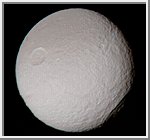
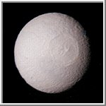
Tethys
This view of Tethys was taken by Voyager 2 on August 26, 1981
from a range of 282,000 kilometers (175,000 miles).
It is the best complete image acquired by the Voyager
spacecraft. An enormous trench named Ithaca Chasma
extends from the left side of this image to the upper center.
The fissure is about 65 kilometers (40 miles) wide,
several kilometers deep, and extends across three-fourths
of Tethys' circumference.
The image also shows two types of terrain one of which is
heavily cratered (top) and the other more lightly cratered (bottom).
Both of Saturn's moons Dione
and Rhea exhibit similar boundaries.
Light cratering indicates that the region was once internally active,
causing partial resurfacing of older terrain.
(Copyright Calvin J. Hamilton)
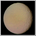
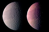 Color Image reveals a Dark Belt on Tethys
This is the best color image of Tethys taken by the Voyager 1 spacecraft.
It was produced by combining three images taken through orange, green
and blue filters. The image on the right has been color and contrast
enhanced in order to emphasize the dark belt that stretches across
the satellite.
The exact cause for the dark band is unknown, but a possible interpretation comes from recent Galileo images of Jupiter's moons Ganymede and Callisto. Both satellites exhibit light polar caps that are made from bright ice deposits on pole-facing slopes of craters. From a distance the caps appear brighter due to a haze caused by thousands of unresolved patches of ice in small craters. The dark band on Tethys may have been formed in a similar manner, consisting of hazy polar caps of unresolved bright ice patches with a dark zone in-between.
Another notable feature is the bright terrain
along the limb in the upper left-hand corner of the image.
This is a cross section through the giant Odysseus impact basin
and shows the fact that the crater must have been formed at a time
when the ice was still relative warm and soft. The crater no longer
shows deep bowl shape characteristics of craters formed in cold ice or rock.
(Copyright Calvin J. Hamilton)
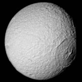
 Highest Resolution Image of Tethys
This is the highest resolution image of Tethys taken by the Voyager 2
spacecraft on August 26, 1981 from
a range of 120,000 kilometers (74,500 miles). The smallest visible
features are about 2.2 kilometers (1.4 miles) across.
The image was to be a part of a global high-resolution mosaic,
but because of problems with the scan platform, Voyager missed
and only caught the corner edge of Tethys. The image shows a
section of heavily cratered terrain. Tethys' low density indicates
that it is composed mostly of water ice.
(Copyright Calvin J. Hamilton)
 Odysseus Basin
Early in the history of Tethys, an impact occurred forming
an enormous 400-kilometer impact basin named Odysseus. The impact scar
spans more than two-fifths of the satellite with a diameter slightly larger
than Saturn's moon Mimas. When Odysseus was first
created, the crater must have been deep with a high mountainous rim and
towering central peak. Over time the crater floor relaxed to the spherical shape
of the Tethys' surface, and the crater's rim and central peak collapsed.
(Similar relaxation is apparent on Jupiter's moons
Callisto and
Ganymede.)
At the time of the Odysseus impact, Tethys must have been sufficiently
warm and malleable to allow the topography to collapse. Tethys' interior
may have even been liquid. If Tethys had been colder and more brittle at the
time of impact, the moon may have been shattered. If it survived the
impact, the topography of the crater would have retained its shape similar
to Herschel crater on Mimas.
The Voyager 2 spacecraft acquired this image on August 25, 1981
from a range of 826,000 kilometers. The right most edge was missed
by the Voyager imaging system.
(Copyright 1999 by Calvin J. Hamilton)
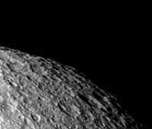
 Crater Odysseus Profile
This image shows a nice profile view of the
giant impact basin Odysseus (lower right-hand limb). Because Tethys was warmer when the
impact occurred, the crater floor relaxed to the spherical shape
of Tethys' surface, and the crater's rim and central peak collapsed. Towards
the upper-right limb is a portion of the immense trench Ithaca Chasma.
The Voyager 2 spacecraft acquired this image on August 25, 1981
from a range of 680,000 kilometers (420,000 miles).
(Copyright 1999 by Calvin J. Hamilton)
 Color Image of Odysseus Crater
This color image shows another nice view of the Odysseus impact basin.
It was acquired by the Voyager 2 spacecraft
from a range of 1.1 million kilometers (670,000 miles).
(Copyright 1999 by Calvin J. Hamilton)
 Tethys Color Composite
This view of Tethys is a color composite of three images
taken by Voyager 2 on August 25, 1981 from a range of
594,000 kilometers (368,000 miles).
Ithaca Chasma, an enormous trench that is 65 kilometers
(40 miles) wide and several kilometers deep,
runs parallel to the terminator at the right.
(Copyright Calvin J. Hamilton)
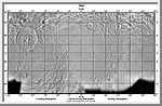 Mercator Map of Tethys
This image is a mercator map of Tethys. It was made from images taken by
the Voyager 2 spacecraft. The map covers the region from -70° to 70°
latitude.
(A. Tayfun Oner)
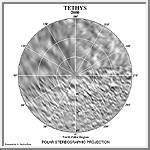 North Polar Map of Tethys
This image in a north polar stereographic projection map of Tethys
It covers latitudes 65 to 90 degrees and was made from images taken by
the Voyager 2 spacecraft.
(A. Tayfun Oner)
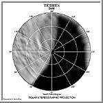 South Polar Map of Tethys
This image in a south polar stereographic projection map of Tethys
It covers latitudes 65 to 90 degrees and was made from images taken by
the Voyager 2 spacecraft.
(A. Tayfun Oner)
Copyright © 1997-2000 by Calvin J. Hamilton. All rights reserved. Privacy Statement.

 Saturn
 Enceladus
 Calypso