|
COMETS EARTH JUPITER KUIPER BELT MARS MERCURY METEORITES NEPTUNE OORT CLOUD PLUTO SATURN SOLAR SYSTEM SPACE SUN URANUS VENUS ORDER PRINTS
PHOTO CATEGORIES SCIENCEVIEWS AMERICAN INDIAN AMPHIBIANS BIRDS BUGS FINE ART FOSSILS THE ISLANDS HISTORICAL PHOTOS MAMMALS OTHER PARKS PLANTS RELIGIOUS REPTILES SCIENCEVIEWS PRINTS
|
Related Document
Download Options
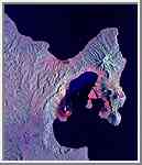
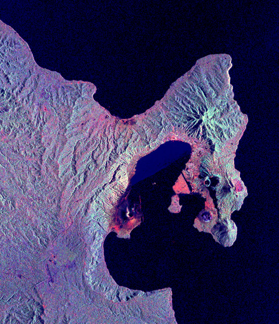
This is a radar image of the Rabaul volcano on the island of New Britain, Papua New Guinea taken almost a month after its September 19, 1994, eruption that killed five people and covered the town of Rabaul and nearby villages with up to 75 centimeters (30 inches) of ash. More than 53,000 people have been displaced by the eruption. The image was acquired by the Spaceborne Imaging Radar-C/X-band Synthetic Aperture Radar (SIR-C/X-SAR) aboard the space shuttle Endeavour on its 173rd orbit on October 11, 1994. This image is centered at 4.2 degrees south latitude and 152.2 degrees east longitude in the southwest Pacific Ocean. The area shown is approximately 21 kilometers by 25 kilometers (13 miles by 15.5 miles). North is toward the upper right. The colors in this image were obtained using the following radar channels: red represents the L-band (horizontally transmitted and received); green represents the L-band (horizontally transmitted and vertically received); blue represents the C- band (horizontally transmitted and vertically received). Most of the Rabaul volcano is underwater and the caldera (crater) creates Blanche Bay, the semi-circular body of water that occupies most of the center of the image. Volcanic vents within the caldera are visible in the image and include Vulcan, on a peninsula on the west side of the bay, and Rabalanakaia and Tavurvur (the circular purple feature near the mouth of the bay) on the east side. Both Vulcan and Tavurvur were active during the 1994 eruption. Ash deposits appear red-orange on the image, and are most prominent on the south flanks of Vulcan and north and northwest of Tavurvur. A faint blue patch in the water in the center of the image is a large raft of floating pumice fragments that were ejected from Vulcan during the eruption and clog the inner bay. Visible on the east side of the bay are the grid-like patterns of the streets of Rabaul and an airstrip, which appears as a dark northwest-trending band at the right-center of the image. Ashfall and subsequent rains caused the collapse of most buildings in the town of Rabaul. Mudflows and flooding continue to pose serious threats to the town and surrounding villages. Volcanologists and local authorities expect to use data such as this radar image to assist them in identifying the mechanisms of the eruption and future hazardous conditions that may be associated with the vigorously active volcano. Spaceborne Imaging Radar-C/X-band Synthetic Aperture Radar (SIR-C/X-SAR) is part of NASA's Mission to Planet Earth. The radars illuminate Earth with microwaves, allowing detailed observations at any time, regardless of weather or sunlight conditions. SIR-C/X-SAR uses three microwave wavelengths: L-band (24 cm), C-band (6 cm) and X-band (3 cm). The multi- frequency data will be used by the international scientific community to better understand the global environment and how it is changing. The SIR-C/X-SAR data, complemented by aircraft and ground studies, will give scientists clearer insights into those environmental changes which are caused by nature and those changes which are induced by human activity. SIR-C was developed by NASA's Jet Propulsion Laboratory. X-SAR was developed by the Dornier and Alenia Spazio companies for the German space agency, Deutsche Agentur fuer Raumfahrtangelegenheiten (DARA), and the Italian space agency, Agenzia Spaziale Italiana (ASI), with the Deutsche Forschungsanstalt fuer Luft und Raumfahrt e.v.(DLR), the major partner in science, operations and data processing of X-SAR. |