|
COMETS EARTH JUPITER KUIPER BELT MARS MERCURY METEORITES NEPTUNE OORT CLOUD PLUTO SATURN SOLAR SYSTEM SPACE SUN URANUS VENUS ORDER PRINTS
PHOTO CATEGORIES SCIENCEVIEWS AMERICAN INDIAN AMPHIBIANS BIRDS BUGS FINE ART FOSSILS THE ISLANDS HISTORICAL PHOTOS MAMMALS OTHER PARKS PLANTS RELIGIOUS REPTILES SCIENCEVIEWS PRINTS
|
Related Document
Download Options
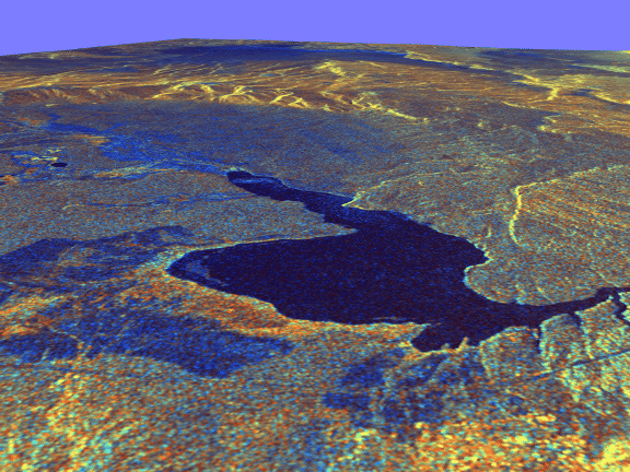
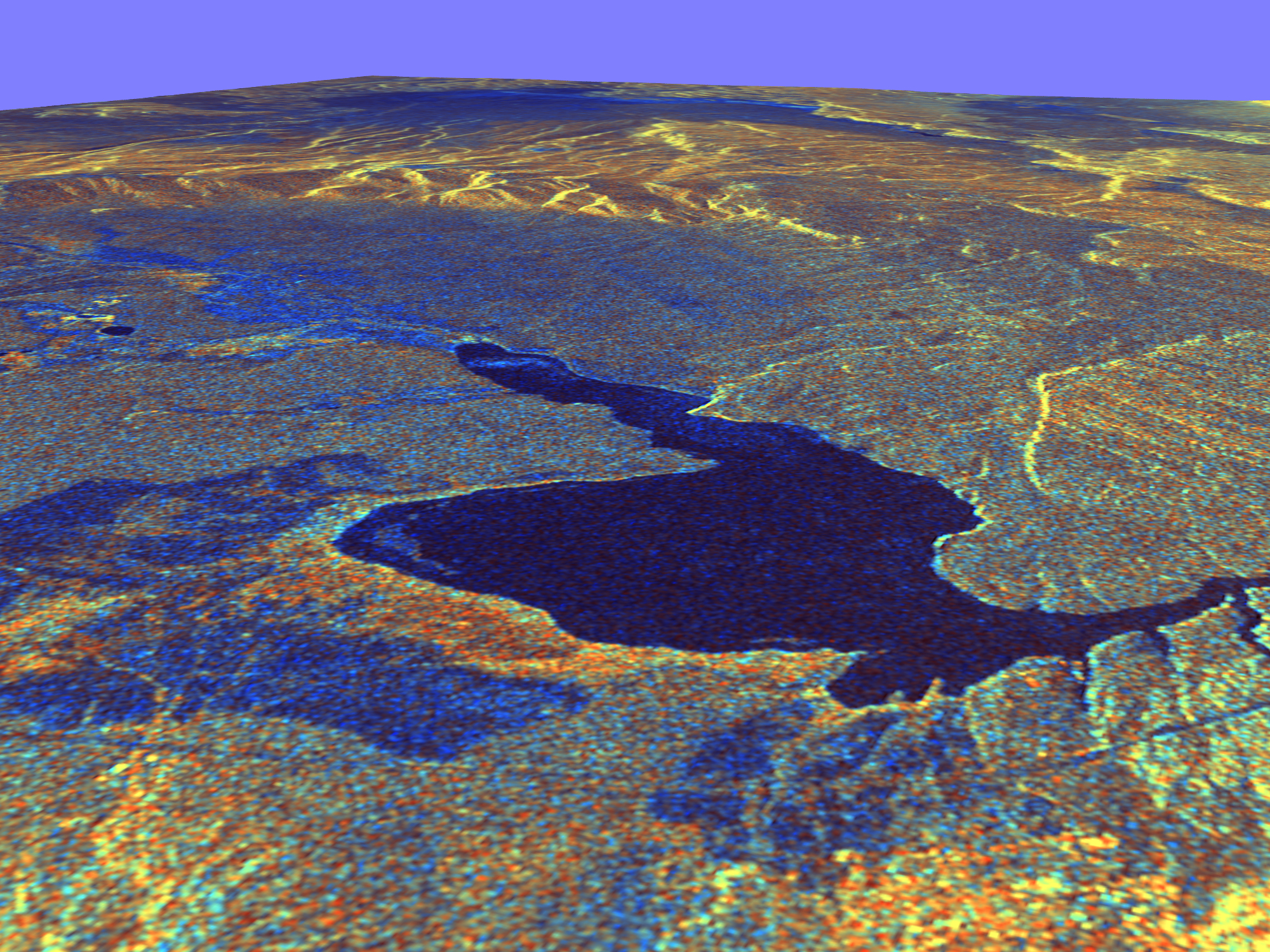
This three-dimensional perspective view of Long Valley, California was created from data taken by the Spaceborne Imaging Radar-C/X-band Synthetic Aperture Radar on board the space shuttle Endeavour. This image was constructed by overlaying a color composite SIR-C radar image on a digital elevation map. The digital elevation map was produced using radar interferometry, a process by which radar data are acquired on different passes of the space shuttle. The two data passes are compared to obtain elevation information. The interferometry data were acquired on April 13, 1994 and on October 3, 1994, during the first and second flights of the SIR-C/X-SAR instrument. The color composite radar image was taken in October and was produced by assigning red to the C-band (horizontally transmitted and vertically received) polarization; green to the C-band (vertically transmitted and received) polarization; and blue to the ratio of the two data sets. Blue areas in the image are smooth and yellow areas are rock outcrops with varying amounts of snow and vegetation. The view is looking north along the northeastern edge of the Long Valley caldera, a volcanic collapse feature created 750,000 years ago and the site of continued subsurface activity. Crowley Lake is the large dark feature in the foreground. Spaceborne Imaging Radar-C and X-band Synthetic Aperture Radar (SIR-C/X-SAR) is part of NASA's Mission to Planet Earth. The radars illuminate Earth with microwaves, allowing detailed observations at any time, regardless of weather or sunlight conditions. SIR-C/X-SAR uses three microwave wavelengths: L-band (24 cm), C-band (6 cm) and X-band (3 cm). The multi-frequency data will be used by the international scientific community to better understand the global environment and how it is changing. The SIR-C/X-SAR data, complemented by aircraft and ground studies, will give scientists clearer insights into those environmental changes which are caused by nature and those changes which are induced by human activity. SIR-C was developed by NASA's Jet Propulsion Laboratory. X-SAR was developed by the Dornier and Alenia Spazio companies for the German space agency, Deutsche Agentur fuer Raumfahrtangelegenheiten (DARA), and the Italian space agency, Agenzia Spaziale Italiana (ASI), with the Deutsche Forschungsanstalt fuer Luft und Raumfahrt e.v.(DLR), the major partner in science, operations and data processing of X-SAR. |