|
COMETS EARTH JUPITER KUIPER BELT MARS MERCURY METEORITES NEPTUNE OORT CLOUD PLUTO SATURN SOLAR SYSTEM SPACE SUN URANUS VENUS ORDER PRINTS
PHOTO CATEGORIES SCIENCEVIEWS AMERICAN INDIAN AMPHIBIANS BIRDS BUGS FINE ART FOSSILS THE ISLANDS HISTORICAL PHOTOS MAMMALS OTHER PARKS PLANTS RELIGIOUS REPTILES SCIENCEVIEWS PRINTS
|
Related Document
Download Options
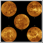
These images are composites of the complete radar image collection obtained by the Magellan mission. The Magellan spacecraft was launched aboard space shuttle Atlantis in May 1989 and began mapping the surface of Venus in September 1990. The spacecraft continued to orbit Venus for four years, returning high-resolution images, altimetry, thermal emissions and gravity maps of 98 percent of the surface. Magellan spacecraft operations ended on October 12, 1994, when the radio contact was lost with the spacecraft during its controlled descent into the deeper portions of the Venusian atmosphere. The surface of Venus is displayed in these five global views. The center image (A) is centered at Venusís north pole. The other four images are centered around the equator of Venus at (B) 0 degrees longitude, (C) 90 degrees east longitude, (D) 180 degrees and (E) 270 degrees east longitude. Magellan synthetic aperture radar mosaics are mapped onto a rectangular latitude-longitude grid to create this image. Data gaps are filled with Pioneer-Venus Orbiter altimetric data, or a constant mid- range value. Simulated color is used to enhance small-scale structure. The simulated hues are based on color images recorded by the Soviet Venera 13 and 14 spacecraft. The bright region near the center in the polar view is Maxwell Montes, the highest mountain range on Venus. Ovda Regio is centered in the (C) 90 degrees east longitude view. Atla Regio is seen prominently in the (D) 180 east longitude view. The scattered dark patches in this image are halos surrounding some of the younger impact craters. This global data set reveals a number of craters consistent with an average Venus surface age of 300 million to 500 million years. |
