|
COMETS EARTH JUPITER KUIPER BELT MARS MERCURY METEORITES NEPTUNE OORT CLOUD PLUTO SATURN SOLAR SYSTEM SPACE SUN URANUS VENUS ORDER PRINTS
PHOTO CATEGORIES SCIENCEVIEWS AMERICAN INDIAN AMPHIBIANS BIRDS BUGS FINE ART FOSSILS THE ISLANDS HISTORICAL PHOTOS MAMMALS OTHER PARKS PLANTS RELIGIOUS REPTILES SCIENCEVIEWS PRINTS
|
Related Documents
Download Options
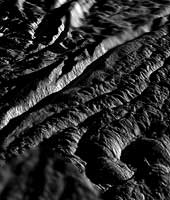
This perspective view of Cairo Sulcus was generated using high resolution images of Enceladus acquired in August 2008 at 12 to 30 meters (40 to 100 feet) resolution, together with a new topographic map of the region produced by Dr. Paul Schenk (http://www.lpi.usra.edu/lpi/schenk/) at the Lunar and Planetary Institute in Houston, TX. Lower resolution images to either side were acquired at 50 to 80 meter (165 to 260 feet) resolution. Cairo Sulcus is one of several prominent structures, dubbed "tiger stripes," within the geologically active south polar region of Enceladus. These structures consist of two large parallel ridges up to 2 kilometers (1.2 miles) across separated by a deep V-shaped medial trough. This view highlights one of the wall scarps of the medial trough of Cairo Sulcus, the brightly lit scarp crossing the left-hand side of the view. This wall scarp stands 175 to 250 meters (575 to 820 feet) high. Vertical striations and large boulders tens of meters across clutter the surface of this scarp, evidence of faulting and/or slumping of crustal ices. Troughs such as these are probably the source of numerous jets making up the large active water vapor plume over the south pole of Enceladus. The parallel sets of rounded mounds and ridges In the foreground are up to 50 meters (165 feet) high. These are typical of the plains that lie between the tiger stripe structures and resemble crumpled or folded rock patterns seen on Earth. Relief has been exaggerated by a factor of ~10 to enhance clarity. |
