|
COMETS EARTH JUPITER KUIPER BELT MARS MERCURY METEORITES NEPTUNE OORT CLOUD PLUTO SATURN SOLAR SYSTEM SPACE SUN URANUS VENUS ORDER PRINTS
PHOTO CATEGORIES SCIENCEVIEWS AMERICAN INDIAN AMPHIBIANS BIRDS BUGS FINE ART FOSSILS THE ISLANDS HISTORICAL PHOTOS MAMMALS OTHER PARKS PLANTS RELIGIOUS REPTILES SCIENCEVIEWS PRINTS
|
Related Documents
Download Options
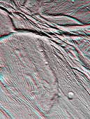
The Cassini narrow angle camera took images of the ropy, taffy-like topography of Saturn's moon Enceladus from many different angles as the spacecraft flew by on Feb. 17, 2005. Images from different directions allow construction of stereo views such as this, which are helpful in interpreting the complex topography. This view of an area about 60 kilometers (37 miles) across shows several different kinds of ridge-and-trough topography, indicative of a variety of horizontal forces near the surface of this 505-kilometer (314-mile) diameter satellite. Several different kinds of deformation are visible, and a small population of impact craters shows that this is some of the younger terrain on Enceladus. Sunlight illuminates the scene from the bottom. Interestingly, the topographic relief is only about one kilometer, which is quite low for a small, low-gravity satellite. However, this is consistent with other evidence that points to interior melting and resurfacing in Enceladus' history. The images for this anaglyph were taken in visible light with the narrow angle camera, from distances ranging from 10,750 kilometers (6,680 miles, red image) to 24,861 kilometers (15,448 miles, blue image) from Enceladus, and at Sun-Enceladus-spacecraft, or phase, angles from 32 to 27 degrees. Pixel scale in the red image is 60 meters (197 feet) per pixel; scale in the blue image is 150 meters (492 feet) per pixel. The images have been contrast-enhanced to aid visibility. A separate, non-stereo version of the scene, showing only the red image is also available (see PIA06190). |
