|
COMETS EARTH JUPITER KUIPER BELT MARS MERCURY METEORITES NEPTUNE OORT CLOUD PLUTO SATURN SOLAR SYSTEM SPACE SUN URANUS VENUS ORDER PRINTS
PHOTO CATEGORIES SCIENCEVIEWS AMERICAN INDIAN AMPHIBIANS BIRDS BUGS FINE ART FOSSILS THE ISLANDS HISTORICAL PHOTOS MAMMALS OTHER PARKS PLANTS RELIGIOUS REPTILES SCIENCEVIEWS PRINTS
|
Related Documents
Download Options
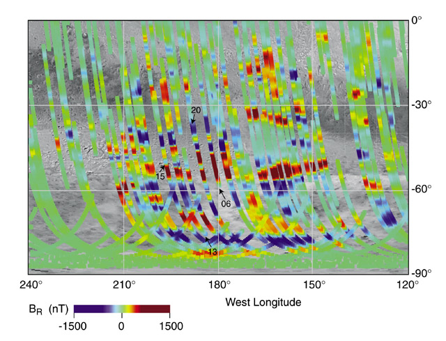
This image is a close-up from a map of Martian magnetic fields, created using the magnetometer/electron reflectometer instrument on board NASA's Mars Global Surveyor spacecraft. The false blue and red colors represent invisible magnetic fields in the Martian crust that point in opposite directions. The magnetic fields appear to be organized in bands, with adjacent bands pointing in opposite directions, giving these stripes a striking similarity to patterns seen in the Earth's crust at the mid-oceanic ridges. On the Earth, the sea floor slowly spreads apart as new crust is extruded from Earth's hot interior, with the resulting stripes carrying a frozen record of the past few hundred million years of Earth's magnetic history. This area on Mars is in the southern highlands near the Terra Cimmeria and Terra Sirenum regions, centered around 180 degrees longitude from the equator to the pole. It is where magnetic stripes possibly resulting from crustal movement are most prominent. The bands are oriented approximately east - west and are about 100 miles wide and 600 miles long, although the longest band stretches more than 1200 miles. |