|
COMETS EARTH JUPITER KUIPER BELT MARS MERCURY METEORITES NEPTUNE OORT CLOUD PLUTO SATURN SOLAR SYSTEM SPACE SUN URANUS VENUS ORDER PRINTS
PHOTO CATEGORIES SCIENCEVIEWS AMERICAN INDIAN AMPHIBIANS BIRDS BUGS FINE ART FOSSILS THE ISLANDS HISTORICAL PHOTOS MAMMALS OTHER PARKS PLANTS RELIGIOUS REPTILES SCIENCEVIEWS PRINTS
|
Related Document
Download Options
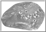
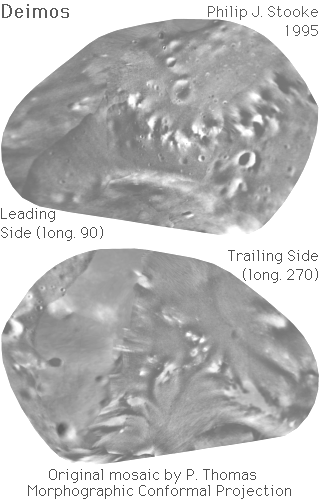
This image is a photomosaic of Deimos, the outer satellite of Mars. The original mosaic, at much higher resolution than shown here, was prepared by Peter Thomas and colleagues at Cornell University. It was published in a cylindrical map projection in: Thomas, P.C., 1993. "Gravity, Tides, and Topography on Small Satellites and Asteroids: Application to Surface Features of the Martian Satellites", ICARUS, V. 105, pp. 326-344, 1993.Positions in the mosaic are controlled by a new shape model, discussed in that paper. A print of the cylindrical projection and the digital shape data were kindly provided by P. Thomas. I have used Viking and Mariner 9 images to fill a large gap in the published mosaic. This required small changes to the shape model, and the positional accuracy of the mosaic in this region (longitudes 300 to 350 degrees, left-hand side of the lower image) is not as great as in the rest of the mosaic. For the image presented here, the three dimensional convex hull of the shape model was projected into the Morphographic Conformal Projection (the conventional Stereographic Projection modified for non-spherical worlds). The cylindrical projection mosaic was scanned and reprojected to fit the Morphographic grid. A higher resolution version of this map with latitude-longitude grid and feature names will be published in 1995. The leading side (longitude 90 runs vertically down the centre) faces forwards in the orbit of Deimos. The trailing side (longitude 270 runs vertically down its centre) faces backwards along the orbit. Longitude 0 is at the blunter end with the most prominent craters, and faces Mars. As with all conformal (true shape) projections, the scale in these maps varies, increasing from the centre to the outer edge. The map projection is described in: Stooke, P.J. and Keller, C.P., 1990. "Map Projections for Non-Spherical Worlds / the Variable-Radius Map Projections", CARTOGRAPHICA, V. 27, No. 2, pp. 82-100. This version of the file, with labels intact, is in the public domain. Philip Stooke, Department of Geography, University of Western Ontario, London, Ontario, Canada N6A 5C2 stooke@sscl.uwo.ca |