|
COMETS EARTH JUPITER KUIPER BELT MARS MERCURY METEORITES NEPTUNE OORT CLOUD PLUTO SATURN SOLAR SYSTEM SPACE SUN URANUS VENUS ORDER PRINTS
PHOTO CATEGORIES SCIENCEVIEWS AMERICAN INDIAN AMPHIBIANS BIRDS BUGS FINE ART FOSSILS THE ISLANDS HISTORICAL PHOTOS MAMMALS OTHER PARKS PLANTS RELIGIOUS REPTILES SCIENCEVIEWS PRINTS
|
Related Documents
Download Options
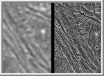
These images demonstrate the dramatic improvement in the resolution of pictures that NASA's Galileo spacecraft is returning compared to previous images of the Jupiter system. The frame at left was taken by the Voyager 2 spacecraft when it flew by in 1979, with a resolution of about 1.3 kilometers (0.8 mile) per pixel. The frame at right showing the same area was captured by Galileo during its first flyby of Ganymede on June 27, 1996; it has a resolution of about 74 meters (243 feet) per pixel, more than 17 times better than that of the Voyager image. In the Voyager frame, line-like bright and dark bands can be seen but their detailed structure and origin are not clear. In the Galileo image, each band is now seen to be composed of many smaller ridges. The structure and shape of the ridges permit scientists to determine their origin and their relation to other terrains, helping to unravel the complex history of the planet-sized moon. In each of these frames, north is to the top, and the sun illuminates the surface from the lower left nearly overhead (about 77 degrees above the horizon). The area shown, at latitude 10 degrees north, 167 degrees west, is about 35 by 55 kilometers (25 by 34 miles). The image was taken June 27 when Galileo was 7,448 kilometers (4.628 miles) away from Ganymede. The Jet Propulsion Laboratory manages the Galileo mission for NASA's Office of Space Science. |
