|
COMETS EARTH JUPITER KUIPER BELT MARS MERCURY METEORITES NEPTUNE OORT CLOUD PLUTO SATURN SOLAR SYSTEM SPACE SUN URANUS VENUS ORDER PRINTS
PHOTO CATEGORIES SCIENCEVIEWS AMERICAN INDIAN AMPHIBIANS BIRDS BUGS FINE ART FOSSILS THE ISLANDS HISTORICAL PHOTOS MAMMALS OTHER PARKS PLANTS RELIGIOUS REPTILES SCIENCEVIEWS PRINTS
|
Related Document
Download Options
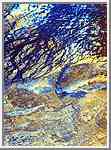
This is a false-color image of the uninhabited Safsaf Oasis in southern Egypt near the Egypt/Sudan border. It was produced from data obtained from the L-band and C-band radars that are part of the Spaceborne Imaging Radar C/X-Band Synthetic Aperture Radar (SIR-C/X-SAR) onboard space shuttle Endeavour on April 9, 1994. The image is centered at 22 degree north latitude, 29 degrees east longitude. It shows detailed structures of bedrock; the dark blue sinuous lines are braided channels that occupy part of an old broad river valley. On the ground and in optical photographs, this big valley and the channels in it are invisible because they are entirely covered by windblown sand. Some of these same channels were observed in SIR-A images in 1981. It is hypothesized that the large valley was carved by one of several ancient predecessor rivers that crossed this part of North Africa, flowing westward, tens of millions of years before the Nile River existed. The Nile flows north about 300 kilometers (200 miles) to the east. The small channels are younger, and probably formed during relatively wet climatic periods within the past few hundred thousand years. This image shows that the channels are in a river valley located in an area where U.S. Geological Survey geologists and archeologists discovered an unsual concentration of handaxes (stone tools) used by Early Man (Homo erectus) hundreds of thousands of years ago. The image clearly shows that in wetter times, the valley would have supported game animals and vegetation. Today, as a result of climate change,the area in uninhabited and lacks water except for a few scattered oases. This color composite image was produced from C-band and L-band horizontal polarization images. The C- band image was assigned red, the L-band (HH) polarization image is shown in green, and the ratio of these two images (LHH/CHH) appears in blue. The primary and composite colors on the image indicate the degree to which the C-band, H-band, their ratio -- or some combination of all three -- respond to the roughness of the radar backscattering surface. Using this coloring scheme, areas that appear bright at both L-band and C-band are colored yellow, while areas that appear brighter at L-band than C-band appear more blue. Detailed analysis of this scene indicates that the separate C-band and L-band images used to produce this color composite have a very similar overall appearance. This suggests that the C- band and the L-band signals are both easily penetrating the thin 1- to 12-centimeter (0.5- to 5-inch) "average" surface cover of loose windblown sand, and are commonly "seeing" similar interfaces just below that cover. This radar interface may be at the scattered rocky outcrops on the ground surface, but is more likely to be the shallow underlying surfaces of river gravel or bedrock, which are generally covered by only a few inches of windblown sand. Virtually everything visible on this radar composite image cannot be seen, either when standing on the ground or when viewing photographs or satellite images such as the United States' Landsat or the French SPOT satellite. |