|
COMETS EARTH JUPITER KUIPER BELT MARS MERCURY METEORITES NEPTUNE OORT CLOUD PLUTO SATURN SOLAR SYSTEM SPACE SUN URANUS VENUS ORDER PRINTS
PHOTO CATEGORIES SCIENCEVIEWS AMERICAN INDIAN AMPHIBIANS BIRDS BUGS FINE ART FOSSILS THE ISLANDS HISTORICAL PHOTOS MAMMALS OTHER PARKS PLANTS RELIGIOUS REPTILES SCIENCEVIEWS PRINTS
|
Related Document
Download Options
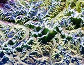
This is a radar image of Mount Everest and its surroundings, along the border of Nepal and Tibet. The peak of Mount Everest, the highest elevation on Earth at 8,848 meters (29,030 feet), can be seen near the center of each image. It shows an area approximately 70 kilometers by 38 kilometers (43 miles by 24 miles) that is centered at 28.0 degrees north latitude and 86.9 degrees east longitude. North is toward the upper left. Many features of the Himalayan terrain are visible in the image. Snow covered areas appear bright blue in the image which was taken in early spring and shows deep snow cover. The curving and branching features seen are glaciers. Radar is sensitive to characteristics of the glacier surfaces that are not detected by conventional photography, such as the ice roughness, water content and stratification. For this reason, the glaciers show a variety of colors (blue, purple, red, yellow, white) but only appear as gray or white in an optical photograph. |