|
COMETS EARTH JUPITER KUIPER BELT MARS MERCURY METEORITES NEPTUNE OORT CLOUD PLUTO SATURN SOLAR SYSTEM SPACE SUN URANUS VENUS ORDER PRINTS
PHOTO CATEGORIES SCIENCEVIEWS AMERICAN INDIAN AMPHIBIANS BIRDS BUGS FINE ART FOSSILS THE ISLANDS HISTORICAL PHOTOS MAMMALS OTHER PARKS PLANTS RELIGIOUS REPTILES SCIENCEVIEWS PRINTS
|
Related Document
Download Options
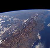
The Andes mountains form one of the longest continuous mountain ranges on Earth, extending from the shores of the Caribbean as far south as the Magellan Straits. Perhaps the most surprising aspect of this range is how narrow it is over much of its length - the high part of the range is typically less than 150 kilometers (93 miles) broad. Illustrated is the section of the Andes near Coquimbo, Chile, where the highest peaks are 6,300 meters (20,670 feet). Low lighting and the oblique perspective emphasize the narrowness of the range, which forms a formidable natural obstacle, and explains how the improbably long and thin country of Chile acquired its identity. In this part of the range, active volcanism is absent. The Benioff zone in this region has a very shallow dip (10°). To both north and south, the Benioff zone dips more steeply (30°) and volcanism is well developed. Clouds illuminated by the low sun hang over the Argentine Pampas beyond the Andes and illustrate the marked climatic differences between different sides of the Andes. In the south, the Chilean side of the Andes tends to be well watered and fertile, while the pampas are in rain shadow and tend to be very dry. Further north, the Chilean coast is exceptionally dry (and forms the Atacama desert) while the eastern slopes are much wetter. |
