NASA SP-441: VIKING ORBITER VIEWS OF
MARS
- SURFACE PROCESSES -
[107] THE MARTIAN
SURFACE, has been subjected to a wide variety of processes,
collectively termed gradation, throughout its geological history. The
net effect of gradation is to bring planetary surfaces to a common
level by eroding topographically high areas and filling in low areas
by deposition. Thus, gradation involves the weathering, erosion,
transportation, and deposition of surface materials by wind, water
(frozen or liquid), and gravity.
Even before spacecraft were sent to Mars,
telescopic observations showed that dust storms are common, and it
was speculated that these storms could alter the surface. When
Mariner 9 arrived at Mars, a major dust storm had obscured the
surface of the planet. After the dust storm cleared, the Mariner
cameras revealed a wide variety of landforms related to aeolian
(wind-related) processes, including dune fields, yardangs, and
shifting albedo patterns consisting of light and dark streaks. The
Viking orbiters and landers have provided much additional information
on both aeolian processes and landforms.
In the tenuous atmosphere of Mars, much
stronger winds than those on Earth arc required to pick up particles
and set them into motion. Winds of some 150 kph are estimated as
minimum for initiation of particle movement. Viking orbiter pictures
show several areas in which storms seem to originate; these areas
include Daedalia, Hellas, and Syrtis Major, which also display:
numerous "streaks" associated with craters. Streaks appear to be
zones in which fine-grained particles arc, redistributed in response,
to wind patterns generated around craters and other landforms.
Some areas on Mars appear to be zones of
deposition for windblown particles, as evidenced by enormous dune
fields. These areas include the north polar region, the floor of the
large impact basin, Hellas, and the floors of other smaller impact
craters. The most spectacular of the dune fields, those at the north
pole, are discussed in the section Polar Regions.
Wind-eroded features include yardangs and
grooves etched in some plains. Because the atmosphere is very thin
the wind speeds needed to move particles are much higher on Mars than
on Earth, so that the grains travel much faster once set into motion.
Consequently, when they strike other particles and bedrock surfaces,
they have a greater erosion capability than they would have on
Earth.
Mass wasting is the downslope movement of
materials, primarily caused by gravity, and is seen as landslides,
avalanches, and soil creep. Its c effectiveness is controlled by
factors like cohesion of the material, steepness of slope, gravity,
and the presence of lubricants such as liquids and volatiles. Mariner
9 and Viking pictures show many features that can be attributed to
[108]
mass wasting. Mass wasting along the walls of Valles Marineris has
produced some of the most spectacular landslides observed
anywhere.
Surface and near-surface processes that occur
in the vicinity of former and existing ice regions are referred to as
periglacial processes. Although periglacial features and related
phenomena have not been positively identified on Mars, it is
reasonable to expect them in view of the low temperatures and the
probable existence of subsurface ice in some regions. "Etch" pits,
polygonal ground, and rock "glaciers" are among the features observed
from orbit that may be related to periglacial processes on Mars.
[109]

|
|
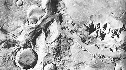
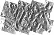
Sand Dunes and Landslides in
Valles Marineris. A
40-km-long field of sand dunes (dark area in lower left) and
a massive avalanche (middle of mosaic) are seen here on the
floor of Gangis Chasma, one of the branches of Valles
Marineris. In this region, the walls have been modified by
landslides. Debris flows are numerous, as are jumbled masses
of debris below the cliffs. Wind may be an effective agent
in removing debris that has slumped into the canyon. The
canyon thus enlarges itself by the combined processes of
slumping and wind excavation. [P16941; 7°S,
45°W]
|
[110]
|
|
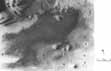
Details of Valles Marineris Sand
Dunes. An enlargement of the
dune field on the preceding picture is presented here to
show individual dunes about 500 meters across. The wind
appears to have been blowing from the west and leading dunes
to the east appear to climb the canyon wall. [P16950;
7°S, 45°W]
|
|
|
|
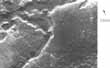
Landslide in Noctis
Labyrinthus. This landslide
mass completely fills the floor of the canyon. The canyons
in this area appear to be graben that resulted from crustal
extension with subsequent widening and modification by
landslides. [46A19-22; 10°S, 96°W]
|
|
[111]

|
|
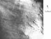
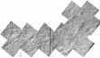
Small Dune Field in Kaiser
Crater. Craters and other
topographic depressions are natural traps for windblown
sediments. The crater shown here is typical of many that
have been photographed from orbit. [94A42; 46°S,
339° W]
|
[112]

|
|
Part of the Dune Field in the
North Polar Region. The dune
field covers an area of at least 3500 km2 and is composed of
barchan (crescent-shaped) dunes. In the area shown here, the
dunes s are aligned in ridges that appear to be transverse
to the prevailing wind. From the relation of the dune field
to the crater at the bottom of the picture, the prevailing
winds se e m to be from the west (left side of picture).
[59B65; 76° N, 88° W]
|
|
|
|
Barchan Dunes at Edge of North
Polar Cap. This figure shows
the well-defined lines of individual barchan dunes. The wind
direction is from left to right. [58B22; 75° N,
53° W]
|
|
[113]

|
|
"Etched" Terrain in Southern
Chryse Planitia. This etched
terrain shows light-toned, angular depressions in southern
Chryse Planitia in the area where Tiu Vallis empties into
the Chryse basin. The etching process that removed the dark
plains material may be the result of cavitation or plucking
during active channel formation or wind deflation. Many
small, volcano-like features occur in this region. The arrow
points to one of these features, a low mound with a summit
crater. This feature (also discussed in the Volcanoes
section) lies on a sinuous line of unknown origin; the line
may be the trace of a fracture or possibly a dike.
[211-4990; 19° N, 35° W]
|
[114]

|
|
Northern Contact of Chryse
Planitia. Chryse Planitia
"plateau", the mottled light surface at the bottom, is shown
at its contact with the darker plains. Irregular pits on the
plateau (lower right) suggest formation by collapse: the
scalloped scarp of the plateau seems to result from scarp
retreat am] the connection of' the irregular pits. The
morphology of the pits and scarp resembles thermokarst
features on Earth that result from the melting of ground ice
and the subsequent settling of the ground. [211-4994:
23° N, 36° W]
|
[115]

|
|
Concentric Flow Features at the
Foot of Olympus Mons Scarp.
These flow features are more like those typically developped
on avalanches and landslides. The unit on which they occur
is probably material formed by landsliding on the scarp
front. This process may have played a major part in
developing the scarp around the volcano. [48B04; 23°N,
138° W]
|
[116]
|
|
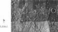
Mosaic of the Nilosyrtis
Region. This is a
transitional zone between an ancient cratered terrain to the
south (bottom) and sparsely cratered terrain to the north.
In many of the low-lying areas there are sub-parallel ridges
and grooves that suggest creep of near-surface materials.
They resemble terrestrial features where near-surface
materials flow en masse very slowly, aided by the freeze and
thaw of interstitial ice water frozen between layers of
ground materials. This is additional evidence suggesting the
presence of ground ice in the near surface materials of
Mars. [P-18086; 34°N, 290°W]
|
[117]

|
|
Flow Structures in Ancient
Cratered Terrain East of Hellas. Mass- wasting structures around positive
features extend up to 20 km from the source. The aprons are
not composed of discrete lobate flows, as would be expected
if they were formed by landslides, nor are they talus
deposits close to the angle of repose; surface slopes are
probably less than 10°. Instead, these features may be
the result of slow creep of debris containing interstitial
ice. [97A62; 41° S, 257° W]
|
|
|
|
Chaotic Terrain North of
Elysium. The plains of the
south (lower half of this mosaic) appear to have partly
collapsed and then eroded so that only isolated remnants
remain. Collapse may have occurred as a result of removal of
subsurface ice. A process of planation appears to have
removed materials down to a specific depth and created a new
planar surface at that depth. It is unclear what the erosive
mechanism was or where the material went. [211-5274;
33° N, 213° W]
|
|
|
[118-119]
Contrasting Terrain West of
Deuteronilus Mensae. (a) The
smooth areas shown may be either debris mantles or remnants
of older terrain. In the textured areas, the linear markings
may mark the position of former escarpments- the outline of
smooth areas. [52A31-44; 44°N, 352°W]
|
|
[120]

|
|
Contrasting Terrain West of
Deuteronilus Mensae. (b) A
view is shown of part of the Cydonia region of Mars, a
65-km-long remnant of the same plateau unit shown in (a).
[26A72; 45°N, 7°W]
|
[121]
(a) 
|
|
Striped Ground. (a) Geometric markings resembling contour
plowing in the Cydonia region are seen, and consist of low
ridges and valleys about l km from crest to crest. 'The
features may mark successive positions of the retreat of an
escarpment during removal of a plateau or mantling unit. (b)
In this high resolution image of striped ground similar to
that in (a), the parallel markings are caused by low ridges
and, less commonly, shallow depressions. [(a) P- 17599;
46° N, 350° W, (b) 11B01; 50° N, 289°
W]
|
(b) 
|
[122]

|
|
Highly Textured Eroded
Surface. The upper half of
this image shows a layer of relatively erodable material
that is being sculpted d and swept away by the wind. In the
lower left a more resistant older surface has been exposed
which is dominated by small hills and sinuous narrow ridges.
The hill at the bottom may be of volcanic origin. The narrow
ridges are especially puzzling. It has been suggested that
they may be dikes but their extensive continuity and
ridge-like surface forms argue against this. An alternative,
but weaker, hypothesis is that they may be esters. [72
4A22;2° S, 210° W ]
|


