|
|
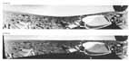
[142] Your impression of Mars depends upon your point of view, literally. Using an extreme example, the landscape as depicted by the Lander cameras, situated a little more than 1 m above the surface, has little in common with the landscape photographed by the Orbiter cameras, 1500 km above the surface. The principal difference is in scale. The resolution from orbit is about 50 m, precluding any possibility of directly detecting the Lander. In addition there are few, if any, large diagnostic landforms that can be identified in both Orbiter and Lander pictures. This situation may be improved in the future. Newly obtained higher resolution Orbiter images will allow us to refine the position of the Lander to within about 40 m.
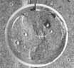
Figure 204 illustrates our best estimate at correlation of Lander and Orbiter pictures. Lander 1 panoramas have been computer distorted into a circular format, something like the image obtained with the fisheye lens of a conventional film camera. This makes it easier to correlate the image with an Orbiter picture. For example, moving out along a straight line from the center, any feature intersected in the Orbiter picture should [143] also be intersected in the Lander picture. The crater rim indicated at point A in the Lander picture is probably the same one indicated at point B in the Orbiter picture. (For a better rendition of the crater, see figs. 77, 78, and 79.) Other nearby distinctive features in the Orbiter picture may be masked in Lander pictures by local hills and rises. Incidentally, the landing site viewed from orbit resembles a sparsely cratered lava plain, very similar to the dark lunar maria. This is consistent with the interpretation from Lander pictures but, at this more detailed level, the lavas are seen to be broken up and modified by wind action and by other processes.
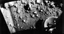
Viking 2 landed on a surface that is difficult to interpret from Orbiter pictures. A muted, mottled texture suggests covering up of subjacent, sharper topography. According to one interpretation, we landed on the outer part of a vast ejecta deposit associated with the 100 km crater, Mie, located 160 km to the northeast. The Lander pictures neither rule out nor confirm this hypothesis. The large blocks could be the residue of a former thick blanket of ejecta that has been winnowed by the wind. No landforms have been uniquely correlated in Orbiter and Lander 2 images.
Viking 1 landed with a tilt of 3° down toward the west. The tilt of Viking 2 is much more noticeable, 8.5° down toward the west (fig. 205). In both cases the tilt causes the horizon to appear as a gentle, undulating curve over the azimuth range of 360°. When the Lander 2 scene is rectified to the perspective of a vertically oriented camera, it appears as in figure 206. Note that the horizon is now almost perfectly horizontal.
Because of the way the camera scans, considerable distortion is introduced in images taken close to the Lander at large depression angles. Individual scan lines can be compared to lines of longitude on a globe. Close to the equator, the spherical surface can be represented on flat paper with little distortion. But, as the lines of longitude approach the pole, they begin to converge. If they are shown on a two dimensional map with the same spacing as at the equator, landmasses near the pole, such as Greenland or Antarctica, are greatly distended. This same effect causes objects photographed near 0° to be faithfully rendered, but objects at the lowest elevation angle of 60° are elongated by a factor of two. The magnitude of the effect can be calculated by comparing figure 207 with figure 24. In the latter case the usual camera perspective is altered to a planar perspective, similar to what your eye would perceive looking directly down on the martian surface.