|
|
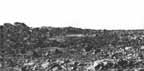
[42] Figures 33 and 34 are two views of sediment drifts showing internal stratification. At first glance these appear to be sets of small scale surface ripples. Closer examination reveals that the linear markings result from erosion of a sequence of sedimentary layers. The same sort of internal stratification can be seen on a seashore beach by trenching through the sand. On a much grander scale, internal stratification of desert dunes is revealed by erosion of Mesozoic rocks in the American Southwest, notably in Bryce and Zion National Parks. In figure 34 the drift at the right of the image displays several prominent ridges. Darker, more resistant layers are revealed on the eroded drift faces, covered by a thin layer of brighter material.
The presence of sedimentary layers within the martian drifts indicates a number of depositional events, each related to a change in the wind conditions. The exposure of the layers indicates that the most recent event is general erosion. If these were actively growing dunes the internal stratification would not be revealed.
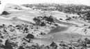
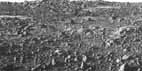
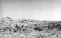
Four views of isolated drifts of sediment about 20 m to the southeast of Lander 1 are shown in figures 35 to 38. One is tempted to call these features sand dunes but the label carries certain implications that cannot be established. First, the constituent particles probably are not sand, but are finer "rained silt and clay. Second, it does not appear that these are actively growing dunes of the type one commonly associates with deserts. Instead, they appear to be stabilized erosional remnants of a formerly more extensive sediment cover.
Figure 36 was taken with diode BB 3 (high resolution, focused at 4.5 m). Better definition of distant objects is rendered in figures 35, 37, and 38, taken with BB 4 (high resolution, focused at 13.3 m). Figures 35 and 37 were taken at approximately the same early morning hour. Figures 36 and 38 were taken near local noon; Sun elevation is about 50°.
The same dark drift that appears in the upper right of figures 35 and 36 is situated in the middle of figures 37 and 38. A much brighter drift is observable in the upper left of figures 35 and 36. The difference in brightness (albedo) suggests a compositional difference. This is substantiated by spectral curves generated from data in the three visible color and three infrared channels. The shape of the spectral reflection curves indicates that the dark dune is enriched in ferrous materials, perhaps the mineral magnetite. Pictures acquired much later in the mission, more than a year after touchdown, show dark patches developing on some bright drifts. This suggests that the bright drifts are, in fact, dark drifts with a thin veneer of bright fine grained dust. Generally analogous situations occur on Earth where grains of heavier minerals such as magnetite are preferentially enriched in certain regions where lighter particles of quartz and feldspar have been swept away by wind.
Near the bottom center in figure 36 there is a cylinder shaped rock. In early news briefings this was nicknamed the "Midas Muffler" rock. However, the same rock as viewed in figure 35 is not so striking-less of a muffler, more of a garden variety boulder.
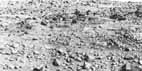
The larger boulders on the horizon are about 90 m distant and about 1 to 2 m in diameter. They appear to be eroded into unusual scalloped shapes, although this may be an illusion rendered by low resolution and high contrast lighting. Finer sediment is banked up within the boulder cluster. The same association of boulders and accumulation of sediment occurs elsewhere in the scene. Knobby bedrock is visible in the foreground, and is described in more detail in the text with figures 52 through 55.