Home Table of Contents What's New Image Index Copyright ScienceViews Search


On Mars: Exploration of the Red Planet. 1958-1978


IMAGES FROM ORBIT


[363] Heterogeneity was the most striking aspect of Mars as scientists identified a greater variety of terrains than known to exist on the moon or Mercury. Conway B. Leovy, a member of the meteorology team, noted: "Unlike the moon, whose story appears essentially to have ended one or two billion years ago, Mars is still evolving and changing. On Mars, as on the earth, the most pervasive agent of change is the planet's atmosphere, itself the product of the sorting of the planet's initial constituents that began soon after it condensed from the primordial cloud of dust and gas that gave rise to the solar system 4.6 billion years ago." 1
 
Some information about the nature of the Martian atmosphere had been derived from telescopic observations and from earlier Mariner missions, but those sources of data were "unverifiable and subject to misinterpretation." With the exception of its significantly different composition and its being "less than a hundredth as dense as that of the earth," the atmosphere of Mars behaves much like that of our own planet. "It transports water, generates clouds and exhibits daily and seasonal wind patterns." Responding to seasonal changes in the heat generated by solar radiation, localized dust storms occur and sometimes grow in strength until they cover the entire planet, a fact with which Mariner and Viking specialists were familiar. Global dust storms appear to be a phenomenon unique to Mars, which lacks large bodies of water that would prevent their buildup.
 
Atmospheric weathering of the primitive crystalline rocks on Mars has reduced them to fine particles that have oxidized and combined chemically with water to produce the reddish minerals so apparent in the color images [364] returned from the Viking landers. Whereas on Earth the dominant weathering process has been from the movement of liquid water, on Mars the primary agent of change has been the wind. It erodes the landscape, transports the dust, and deposits it elsewhere on the planet. The Viking landing sites appear to have been "severely scoured by winds. In addition, pictures taken by the orbiter cameras reveal deep layers of wind-borne sediment in the polar regions, while dunefields of Martian dust and sand much larger than those on Earth were observed near the north pole. 2
 
The geologic history of Mars, according to orbiter imaging team leader Michael H. Carr, "shows evidence of floods and relatively recent volcanic eruptions, at least in the hundreds of millions of years that geology uses as a measure." There are also features that resemble terrestrial river systems. "Apparently tremendous floods occurred many times over Mars' history, indicating that the planet must have been drastically different in the past." 3
 
Earlier Mariner flights indicated the presence of volcanoes on Mars; Viking measured their extent and variety. A large portion of the northern hemisphere is covered by volcanoes, sonic spreading broad lava fields for hundreds of kilometers. Others, such as Olympus Mons and Arsia Mons, rise some 27km above the reference surface level of the planet. Distinct lava flow patterns can be seen 300km from their source in Arsia Mons, with the general pattern of the terrain indicating that the lava may have traveled up to 800 km, the distance from Washington, D.C. to Cincinnati, Ohio. 4 Geologists who have studied the Viking photographs believe that the nature of volcanic activity on Mars is essentially the same as that on Earth-the movement of a basaltic, low-viscosity lava. One kind of volcano appears to be unique to Mars: the patera, or saucer-shaped, volcano with a low profile covering a vast area. Alba Patera, with a maximum diameter of 1600 km, is probably the largest such volcano on the planet. A similar volcano centered on Denver would have spilled its lava across all of Colorado, Wyoming, Utah, large parts of New Mexico, Kansas, Nebraska, South Dakota, and corners of Montana, Idaho, Arizona, Texas, and Oklahoma. Scientists think that the caldera-the crater formed by the collapse of the central part of the volcano-of a patera is the result of simultaneous lifting and collapsing of the sides of the volcano, probably repeated many times over a long period. According to Carr, "the total volumes of lava erupted to produce single flows are orders of magnitudes greater than they are in terrestrial lava flows, and the total volumes of lava erupted from essentially a single vent volcano are enormous." 5 Production of sufficient magma (molten rock) for such lava flows cannot be explained, but as Carr pointed out, the plains regions appear to have been formed several million years ago by this movement of lava. 6
 
In addition to lava, the movement of water also has affected Martian topography. The large riverlike channels are one of the big Martian puzzles. Carr and his colleagues believe there are two major kinds of water features:
 
[365] There are the large flood features and then there are dendritic or branching drainage features that resemble terrestrial river systems. It appears from the crater counts that the fine terrestrial-like river channel systems are older than the flood features. It appears that the large flood features came in middle Mars history. There was a period of vast floods, then the flooding for some reason ceased or became less frequent because we don't have flood features with crater cutouts comparable to those we find on the Tharsis volcanoes. Very early in Mars' history, dendritic drainage patterns developed; in Mars' middle history it had a period of flooding, and then mostly after that the volcanics of Tharsis accumulated. This general picture has collie out of the Viking data.
 
A lot of skeptics didn't believe there had been any period of surface drainage. Some said all those things could easily have been formed by faulting and soon. The Viking pictures are full of examples of dendritic channels. I can't believe there are many skeptics left. I think we have really established that there was this early period of surface drainage. There can be very little doubt about that. 7
 
The scientists are still left with explaining where all the water for the floods and rivers came from. More important, where did it go?
 
Because of low atmospheric pressure at the surface, there are no con- temporary large pools, rivers, or collection basins filled with water, and because of low temperatures the atmosphere cannot contain much water. However, there is probably a great quantity in the permanent polar caps and within the surface. The low pressure permits water to be present only in the solid (ice) or gaseous (water vapor) state. One possible explanation for the apparently contradictory vision of rushing rivers on Mars was presented by Gerald A. Soffen: "Broad channels formed when subsurface water-ice (permafrost) was melted by geothermal activity from deep volcanic centers. When the melting of the permafrost reached a slope the interstitial water suddenly released great flows, sometimes a hundred kilometers wide that modified the channels." 8 Seasonal heating of the permafrost may have occasionally released large flows of water, as well-a possible explanation for the channels that originate in box canyons and spill onto the plains. The easiest method of accounting for the dendritic channels is to conjure up a Martian rainstorm, but that suggestion raises many problems, all of which hinge on the basic question: "How is it possible that these ancient rivers could [have] existed and there be none today?" Obviously, atmospheric pressure would have to have been different during such a period. This hypothesis seems to be supported by studies of the Martian atmosphere encountered by Viking.
 
If the atmospheric pressure once was sufficient to permit the formation of liquid water, how long ago was that? This is still a subject of some debate. Harold Masursky and his colleagues estimated the relative age of the channels by counting the number and judging the age of the craters in and near the channels. The different kinds of channels appear to have been created in....


[366]


The Martian volcano Olympus Mons, at top, was photographed by the Viking I orbiter 31 July 1976 from a distance of 8000 km. The 27-km-high mountain is wreathed in clouds extending 19 km up its flanks. The clouds are thought to be principally water ice condensed as the atmosphere cools. The crater is some 80 km across. At left, Arsia Mons, called South Spot during Mariner 9 mission, is shown in a mosaic of photos taken 22 August. The crater is 120 km across, and the peak rises 16 km above the Tharsis Ridge, itself 11 km high. Vast amount of lava have flooded the plains.


[367]
 
 
A July 9 mosaic of Viking 1 orbiter photos above shows lava flows broken by faults forming ridges. Apparently a small stream once flowed northward (toward upper right) from Lunae Planum, crossed the area, and descended toward the east. In places water may have formed ponds behind ridges before cutting through. At right, a fresh young crater about 30 km across, in Lunae Planum, is near a dry river channel running alongside a cliff in possible lava flows (Kasei Valley). Below, an oblique view across Argyre Planitia (the relatively smooth plain at top center of the photo) shows surrounding heavily cratered terrain. Brightness of the horizon to the right (with north toward upper left) is due mainly to a thin haze. Above the horizon are detached layers of haze 25 to 40 km high, thought to be crystals of carbon dioxide (dry ice). Both the lower photo mosaics were taken 11 July.


[368]....different epochs, or episodes, and all of them at least 50 million years ago and perhaps as long ago as several billion years. 9
 
In addition to the effects of lava and water, shifting of the permafrost also is believed to have influenced the texture of the planet's surface. Investigators assume the existence of permafrost, sometimes to the depth of several kilometers and generally thought to have been present for billions of years. Carr stated:
 
To me one of the more exciting things we've observed is the abundant evidence of permafrost. The most striking features indicative of permafrost occur along the edge of old crater terrain. They form by mass movement of surface material probably aided by the freezing and thawing of ground ice. Another possible indicator of ground ice is the unique character of material ejected from impact craters that is quite different from the pattern on the Moon and on Mercury. We interpret the difference as due to ground ice on Mars. The impact melts the ground ice and lubricates the [ejecta] that is thrown out of the crater so when it lands on the ground it flows away from the crater in a debris flow and forms the characteristic features we have observed.
 
Slow movement and a freeze-thaw cycle could account for the chaotic, jumbled terrain seen over vast stretches of the Martian surface. Irregular depressions caused by localized collapsing of the crust when permafrost thawed could have formed the flat-floored valleys in Siberia and the table-lands of Mars. Large polygonal patterned regions on Mars resemble the ice wedges in terrestrial glacial areas. 10
 
The Martian class of lobate craters is distinct. Unlike lunar craters and those photographed on Mercury, which have radial sunburst patterns caused by ejected debris, on Mars debris apparently flowed smoothly away from the points of impact of many craters. Craters on the moon and Mercury typically had a coarse, disordered texture close to the rim that became finer farther out, grading almost imperceptibly into dense fields of secondary craters. "The most distinctive Martian craters have a quite different pattern. The ejecta commonly appears to consist of several layers, the outer edge of each being marked by a low ridge or escarpment." Recognized in Mariner 9 photographs, the shape was attributed to erosion caused by the wind. With improved-resolution Viking photographs, the geologists have changed their minds; they theorize that on Mars objects also struck the surface with explosive force, but the difference lay in the heating of the permafrost. Resulting steam and momentarily liquid water transported surface materials away from the point of impact and created the distinct lobate flow patterns around the central point. Where the crater ejecta patterns do resemble those on the moon and Mercury, geologists believe that the permafrost was too far below the surface to have been heated, or else possibly absent. 11
 
On a planet that has many spectacular features, one of the most interesting is the Valles Marineris, the Grand Canyon of Mars. First [369] observed by Mariner 9 cameras, only the gross proportion of the canyon system were appreciated at the 1- to 1.5-km resolution. A small sample of higher resolution Mariner 9 photographs (100- 150 meters) hinted at the huge landslides and related features that would be seen on the canyon walls and floors. The images from Viking were much better (resolution of objects as small as 40 meters), and many parts of the 4000-km-long canyon were photographed in stereo, the combination permitting geologists to understand more precisely the processes that formed it. Significantly, neither volcanic activity nor erosion caused by flowing water seems to account for the changes in the Valles Marineris. After examining the Viking photos, Karl R. Blasius and his colleagues believe that tectonic shifting of the planet's crust may have enlarged the canyons. Volcanism was not seen in the Viking images, they point out, and evidence of fluvial activity was only indirect, from chaotic terrain. But tectonic activity appeared to have been prolonged, deepening canyons and offsetting erosion and deposits that would have broadened and filled them. Vertical adjustment of crustal blocks under north-south and east-west extensional stresses appeared to have been the primary process. Some blocks may also have tilted, forming "peculiar slopes near canyon rims and on the intratrough plateau and possibly causing the formation of strings of collapse pits." The history of canyon erosion and deposits was also more complex than had been realized. "Layered materials, including some very regularly imbedded sediments first recognized in the Viking images,'' were highly diverse and widespread. 12
 
One of the basic reasons for studying the Valles Marineris was an interest in the interrelations through time of the volcanic and tectonic forces that produced the large volcanoes to the west-Olympus Mons and the Tharsis craters, which include Arsia Mons-and the development and....


Material appears to have flowed out of the Arandas crater on Mars, rather than being blasted out by the meteorite impact. Radial grooves on the surface of the flow may have been eroded during the last stages of the impact process. Photographed 22 July 1976 by the Viking 1 orbiter at 43°N latitude, 15° longitude, Arandas is about 25 km in diameter.


[370]


More than 100 photos form the top mosaic mapping Valles Marineris, huge Martian complex of Canyons. Taken by the Viking 1 orbiter 23-26 August 1976, they are centered at 5° south latitude, 85° longitude, with north at the top. Ten photos taken 22 August form the center mosaic of the western end of the canyon. The volcanic plateau is deeply dissected into connected depressions.


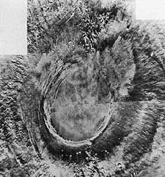
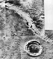
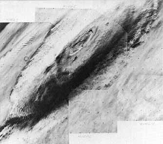
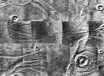
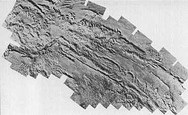
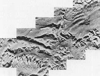
[371]....evolution of the canyon lands. Both geological regions are young in terms of the life of the planet, and changes in both areas likely have continued to the present. Mars and Earth may thus be more alike in geological terms than previously expected. The Viking images have contributed to a new field of study called comparative planetology. Undoubtedly, the wealth of new information gathered by the cameras on the orbiter was ample reward to the people who had fought so strongly to send an improved imaging system to Mars to complement the scientific instruments. As Mike Carr and his associates had predicted in October 1970, "The high-resolution imaging system may be considered as the "meat and potatoes" low-risk but guaranteed-significant-gain experiment in the mission." 13

 
Further analysis of the photographs taken over the Chryse and Cydonia regions during and after landing site certification had indicated that many of the assumptions specialists had made on the basis of Mariner 9 photography had to be changed. Viking science investigators benefited from approaching the planet at a time when it was far from the sun, since lower solar radiation nearly eliminated the worry about dust storms. 14 The clarity of the Viking orbiter images indicated that the Martian atmosphere probably had never cleared during the Mariner 9 mission. Viking 1 arrived at Mars just before the beginning of summer in the northern hemisphere and soon after aphelion. Every Viking scientist reaped benefits from the clear orbiter images, and Ronald Greeley and his geologist colleagues had specific comments about the importance of the Viking orbital pictures in the Chryse and Cydonia regions: "High-resolution Viking orbiter images show Chryse Planitia to be much more complex than had been suspected from Mariner 9 images. Ancient heavily cratered terrain appears to form the basement for the basin. Much of its heavily cratered terrain is mantled with deposits that may be of aeolian, fluvial, or volcanic origin." 15 They were certain that the Mariner 9 view of Mars had been "simplistic." From a close examination of the southern hemisphere, scientists had made some false assumptions about the northern half of the planet. "From Viking photography it is suggested that not only is the northern hemisphere more complicated than was expected, but as....predicted, although the present surfaces are young, some of the rocks exposed at the surface may be old." 16
 
Orbiter photographs coupled with data from the infrared thermal mapper (IRTM) gave scientists a new understanding of the polar caps, too. The Martian poles change dramatically with the seasons. When the Viking craft arrived at the planet, the northern cap had shrunk to its minimum size, revealing the permanent cap, which-contrary to some expectations- consisted of water ice. The part that had dissipated had been made of solid carbon dioxide, dry ice. Meanwhile, the southern ice cap expanded. The northern polar region displayed terraced deposits, indicating an episodic pattern of rapid erosion and deposition of materials. "An unconformity within the layered deposits suggests a complex history of climate change during their time of deposition."


Table 52 [372]

Geological Evolution of Martian North Polar Region

Stage 1

Onset of polar activity.

Moderate aeolian modification of ancient volcanic terrains.

Stage 2

First depositional period.

Layered deposits of silicate dust and possibly interbedded ice accumulate to thickness of several kilometers.

Stage 3

First erosional period.

Erosional attack of layered deposits results in landscape of gently curving scarps and channels with terraced slopes.

Stage 4

Second depositional period.

More layered deposits accumulate unconformably on top of units formed first depositional period.

Stage 5

Second erosional period.

Further erosional attack of layered deposits results in exhumation of earlier formed landscapes and reveals unconformable contacts between deposits of first and second depositional period. Some eroded material reaccumulates as girdle of sand dunes between 75°N and 80 N.

Stage 6

Recent period.

Ice in permanent polar cap assumes its present form and distribution.


While this scenario might not represent a completely accurate explanation of the manner in which the polar terrain evolved, James A. Cutts, Karl Blasius, and associates argue that "it does offer a credible framework....against which further observations and theoretical models may be tested." 17
 
Meanwhile at the south pole, the infrared thermal-mapping team had observed some interesting temperatures. In their first report in Science , Hugh H. Kieffer and his colleagues noted that "areas in the polar night have temperatures distinctly lower than the CO2 condensation point at the surface pressure. "From the atmospheric pressure of 6 millibars at the south pole, the mapping team had anticipated temperatures of about 125°C, the equilibrium temperature for carbon dioxide at that pressure, but, when initial results came in, temperatures as low as 139°C were recorded. The infrared specialists decided that this extra cooling was attributable to a freezing out of the carbon dioxide, leaving a higher concentration of non-condensable gases (such as nitrogen and argon) than is normal for the atmosphere elsewhere. Since these gases would not condense into solid form at - 139°C, that could explain the cooling, but other questions were raised by this theory. 18 How did the non-condensable gases concentrate in the polar region? What did this phenomenon mean for global circulation patterns? What did it tell scientists about the movement of carbon dioxide and other gases from one pole to the other during the change of seasons? [373] Once again, new knowledge raised as many questions as it answered.
 
By the end of the primary mission, the infrared thermal-mapping team had begun to devise theories to answer some of the questions. Large-scale patterns in the temperatures of Mars appear to be similar in size to continental weather patterns on Earth. Viking scientists believe that these patterns may be associated with cloud patterns. As team leader Hugh Kieffer put it, "It's possible we're seeing what I call continental scale weather." Temperatures shortly before dawn in some places are much cooler than expected. Over the Valles Marineris, the temperatures were unexpectedly quite warm before dawn. Kieffer noted that "the temperatures just before dawn are more directly related to the physical properties of the surface because there is no solar energy being absorbed during the 12 hours of night. This means the temperatures are a good indication of how well the surface can hold its heat." 19
 
Infrared thermal-mapping measurements indicated wide daily temperature variations on Mars. The typical day-night variation on Earth is 5° to 10°C, but on Mars the temperature can go from a low of -133° to a high of 4°C. The reason for this wide range is not yet fully understood, nor is the tendency of the temperatures in the afternoon to drop much more quickly than expected. Keiffer reported that in several regions on Mars temperatures begin toward the middle of the afternoon to drop more rapidly than predicted until just before dusk. They may be 10 to 15 degrees cooler than expected. Then they "cease to drop so rapidly and slowly merge with the predictions for the evening." In the afternoon, "the only atmospheric regions that are cooler than the surface are very high and thus we don't know what process at the moment is causing this rapid surface cooling." The process "may be related to clouds in some way, but most of the atmosphere near the ground, where one expects clouds to form, is, in fact, warmer than the surface just before sunset." 20
 
A more important contribution from the infrared thermal-mapping experiment was the discovery of the nature of the polar ice cap. One of the major questions posed by the Mariner 9 data was the composition of the residual polar cap left when the winter polar cap, made of frozen carbon dioxide, retreated in midsummer. A major controversy existed over whether this summer cap seas also frozen carbon dioxide or was frozen water. According to Viking data, the temperatures of the residual cap are near -68° to -63°C, making a case for water frost. Also. the brightness of the frost "indicates it has a lot of dirt mixed in with it. The dirty nature of the ice had also been seen now by the orbital imaging system." Apparently there is no permanent reservoir of carbon dioxide in the polar regions of Mars, a finding that tends to rule out the theory of a rapid climate change induced by the instability of the carbon dioxide on the planet. "This means we still don't have an adequate explanation of how the atmosphere could have been of sufficient density to sustain the liquid water that appears to have flowed at one time in streams and rivers on the surface of Mars,'' said Kieffer. 21