Home Table of Contents What's New Image Index Copyright ScienceViews Search


On Mars: Exploration of the Red Planet. 1958-1978


VIKING l AT MARS


[329] "Planetary operations" began 40 days before orbital insertion, a date chosen arbitrarily. As the first spacecraft approached Mars, the pace quickened on Earth. Much lay directly ahead-final instrument calibrations, optical navigation, course corrections, approach science observations, Mars orbit insertion, spacecraft navigation, landing site certification, entry, landing, and finally initiation of the landed science experiments.
 
During preparation for a planned final Viking 1 course correction maneuver 9 June 1976,10 days before orbital insertion, the orbiter's telemetry revealed a problem. Helium gas was slowly leaking through the gas regulator that pressurized the orbiter's propulsion system. As Tom Young later described it, a ladder series of pyrotechnically operated valves opened and closed the line from a large helium bottle to the gas regulator, and that regulator was in turn connected to the fuel and oxidizer tanks. The regulator was leaking at a rate that would pose a serious problem. The gas did not leak overboard; it leaked into the fuel and oxidizer tanks, and the pressure could rise so high that not only would the engine stop functioning it would explode. 20
 
Should the Viking controllers run the engines in an extra course correction maneuver, or should they fire the last remaining pyrotechnic shutoff valve in the line between the helium tank and the regulator? Another midcourse correction would use up the extra pressure without closing off the gas line, and if the pressure continued to rise after the maneuver it would not be excessive at the time of the final orbital insertion maneuver. But, alternatively, the flight team could close down the pressure line and open it again just before insertion. Jim Martin did not favor the second option because a valve failure would abort the mission. That was a risk he would not take. Martin held "a fairly hairy meeting" at JPL that day, at which he and Young favored another midcourse correction, while nearly all the other members of the team wanted to close the valve. Even John Goodlette, the project's chief engineer, preferred closing the valve. But when Martin telephoned Administrator Fletcher and John Naugle at NASA Headquarters, it was with the news that he was overriding his advisers' suggestion. He was going to make another course correction maneuver on 10 June. 21
 
[330] After that burn was executed, the leak continued, but a second engine burn on 15 June reduced the pressure in the tanks to an acceptable level. After orbital insertion, the line between the helium tank and the faulty regulator was closed and the remaining helium posed no further threat. These two maneuvers slowed the spacecraft down, delaying insertion by 6.2 hours. Additional maneuvers could have held the arrival time constant, but the men in Pasadena preferred not to waste the spacecraft's propellant.
 
Orbital insertion of Viking 1 required a long engine burn-38 minutes of thrust, which consumed 1063 kilograms of propellant and was more than twice the time of the engine burn required by Mariner 9 to enter Mars orbit, Viking had to be slowed from its approach speed of 14400 kilometers per hour to 10400 kilometers per hour for insertion into orbit. To bring the spacecraft to the proper point at its first periapsis, the mission flight path analysts placed it in a long, looping 42.6-hour revolution of the planet, reaching first periapsis at the time originally scheduled for the second. Previously computed timelines could be maintained with only a minimum of modification.
 
Great precision characterized Viking's navigation throughout the mission. After orbit insertion, the orbital period was only l2 minutes shorter than planned, even though the mission could have accepted a much larger error at that stage. And periapsis was only 3 kilometers above the predicted 1511. Other parameters were equally precise. A 21 June trim of the initial orbit adjusted the period to 24 hours 39 minutes 36 seconds, by lowering the apoapsis of the orbit from 50300 to 32800 kilometers without changing the periapsis. This placed Viking 1 in the desired orbit, bringing it over the landing site in Chryse once each Martian day. Because of the 42.6-hour first revolution, for scheduling purposes there never was a "first orbit," The P1 calibration photos were lost, and the first photographs of the Chryse region were not received until the third revolution. 22
 
 
Crisis over Chryse
 
 
On the evening of 22 June 1976, the Landing Site Staff was holding its fifth meeting in what was to stretch into a series of 48 sessions before both Viking spacecraft were on the surface. During their early discussions, the scientists had concentrated on the readiness of men and machines to certify the landing regions. 23 In the midst of another theoretical session on the problem of extrapolating downward from the scale of the images produced by the orbital camera system to the size of the lander, reality intruded. At 6:09 p.m. PDT, the first picture of the landing site appeared on the overhead television monitor in the meeting room, Gentry Lee later told the press, "You would have believed that all the people in that room were ten years old because we all got up and forty of us ran over to the scope and watched it come in line by line." Mars as viewed by Viking 1 did not look like the planet photographed by Mariner 9 , Their landing site, chosen after years of debate, lay on the floor of what looked like a deeply incised river bed. [331] Surprise, shock, and amazement only began to describe the specialists' reactions to this first picture. 24
 
Mike Carr recalled his feelings when the orbiter imaging team members began to look at the P3 data in detail. "We were just astounded- both a mixture of elation and shock. . . . .They were elated at the quality and detail of the pictures but shocked at what they saw. All their data-processing schedules had been based on a preconceived notion of what Mars should look like, and this was not it. The night of 23 June stretched into morning as building 264, which housed the Viking scientists working at JPL, became a beehive of activity. The orbiter imaging team was busy arranging photographs into mosaics, counting craters, and evaluating the geological nature of the region. All that they saw-the etched surfaces, the multitude of craters and islands in the channels (all at the 100-meter scale-told them that the A-1 site was not a suitable place to land. 25
 
The Mars of Viking was strikingly different from the Mars of Mariner for two reasons. First, the Viking cameras permitted the imaging team to see far more detail. And second, they could discriminate ground features more readily because the Martian atmosphere was much clearer. Hal Masursky remarked that large lava flows in the Viking photographs were totally invisible on Mariner images. "There was enough fuzzy in the air so all that stuff just vanished into gently rolling topography. We can see the sharp edges of little tiny lobate lava flows standing on one another." From studying the Mariner findings, the photogeologists had come to believe there were very few small craters on Mars; now they found fields of them. Masursky recalled, "Jim Cutts wanted us to....count all these thousands of craters....That's interesting, but it wasn't necessary for site certification. You can take off your socks and count all the craters you need" to know that it was a dangerous place to land. 26 Masursky and his colleagues now understood that the dust had never really settled during the Mariner 9 mission. Instead of a blurred surface, they now saw a fantastic array of geological detail. Mars was at once an intriguing and forbidding planet.
 
There were other problems, too. At the Landing Site Staff meeting on the 23d, Gentry Lee said that he was nervous about the analysis effort. Great attention had been given to planning the gathering of data, but the analysis was diffuse. Carr and Masursky shared his concern. As the data continued to pour in, it was obvious that more discipline was needed in evaluating the hazards (craters, depressions, knobs, and islands) and mapping the geological structure of the landing area. Meanwhile, new computer programs had to be written and additional consoles rounded up and plugged into the computer at the California Institute of Technology. A series of task groups was established to take on the work, and a group of JPL summer interns (engineering undergraduates) was put to work counting craters and other hazards. Carr reported that there was a period of floundering, but the landing site team soon got reorganized and back on the track. From that point, despite the long hours, the team worked more efficiently. 27


[332] The first closeup of the Chryse region of Mars- the A-1 candidate landing site photographed 22 June 1975 from Viking I orbit- changed the Viking schedule. A channel floor with depressed areas and irregular edges, as well as the many craters, did not make an inviting area for the lander. The center of the photo is at about 18°N latitude, 34° longitude. Other photos (opposite) followed.


At a 24 June Viking press briefing, Lee explained what was going on behind the scenes. Between 300 and 400 persons participated in the site certification process. When the pictures came down from Mars, JPL, the Astrogeology Center at Flagstaff, and several other organizations went to work. Every night, a Landing Site Staff meeting was held, divided into two portions-operational and analytical. Were the photos, mosaics, maps, and the like acceptable and on time? What did it all mean? To find a safe place large enough for a landing ellipse, the team would need more photo coverage, possibly to the northeast or northwest of the prime A-I site. 28 Apparently the spacecraft could go either direction without upsetting the timetable for a Fourth of July landing. 29 The next 28 hours were just the beginning of a very busy, tension-filled period.
 
At noon on 25 June, the press heard from Lee and Care. The Viking Project Office had decided to move the P6 photo coverage 60 kilometers farther to the northeast than previously planned, to avoid the southwestern part of the original landing ellipse where the so-called etched terrain, or scablands, were. Just before midnight on the 24th, the latest P4 photos had come in to fill the gaps in their mosaic. Lee, Carr, Masursky, and nine other members of the imaging team had sat there for more than 30 minutes sliding ellipses around on the mosaic in an effort to find an area where it might be safe to land. So far, there was no safe haven. 30 To study these images, Mike Carr had three groups working for him. Bill Baum led the analysis of atmospheric phenomena. Ronald Greeley was in charge of geological mapping. Jim Cutts and Win Farrell were making quantitative analyses of landing site hazards, and Henry Moore oversaw the mapping of these craters, knobs, and hummocks.
 
Two landing site meetings were held on the 25th. The discussions centered on one key question, "Do we continue at A-1, or do we prepare to go to A-2?" Masursky summed up the situation:


[whole page 333] More photos of the Chryse region on 22-23 June 1976 told the unhappy story. The A-1 landing site was not safe. Above left, a camera on orbiting Viking I photographed an "island" in a rough channel complex with eroded rims. A closer view above right shows a channel and craters. At right, "islands" with etched layers of rock are in the channel of Ares, largest channel in Chryse, in a pair of high-resolution photos. Meteorite-impact craters pepper the surface. Below, a mosaic of 12 photos is the center third of a strip taken by Viking I on its second low pass over Mars on 23 June. A-1 lies toward its center.


[334] The P3 reconnaissance coverage was successful in that it provided some room to maneuver the ellipse when the original location turned out to be unacceptable, and we have some overlap on the last Arecibo radar coverage at 17-18°N.
 
The resolution of the Viking 1 pictures is several orders of magnitude better than Marine 71 at Chryse. We can now see and identify objects as small as 130 meters, so we have a powerful tool for looking at surface angle, the second at a low sun angle....During the second pass, the planet was much closer and more surface textural details could be seen. The planet appears much more clearly now than even during the last of the Mariner 71 mission. The channels (scablands etched in terrain) we are now seeing were the vaguest kind of markings in the '71 pictures; on Viking 1 pictures we can also see layering and ejects blankets, so we are in a much better position to evaluate site hazards and adjust ellipse location. We are moving the ellipse around to avoid islands, craters, ejects blankets, and etched terrain. The current location is about 19.35°N and 32.5°W [the so-called A-1 South site] centered in cratered lunar mare type terrain unit. Many successful landings have been made on the moon in that kind of unit. 31
 
At the end of the staff meeting, a straw vote indicated that 20 members of the group favored staying with A-1, while 24 wanted to move on to A-2. Jim Martin did not vote, but he indicated that he would take all the views into account before the decided which course to follow.
 
Martin was not long in making his decision known. A landing site meeting that lasted most of the day on 26 June suspended the regular order of business to let the group concentrate on two options outlined by Gentry Lee. The spacecraft could be moved immediately to the northwest for a possible landing in the region called Chryse Planitia. Photographs of that area would be compared later with Arecibo radar Coverage scheduled for 4 and 5 July. Or they could reject Chryse altogether and go directly to A-2. Martin explained that he had decided not to land at A-1 (19.5°N, 34°) or the alternate A-1 (19.35°N, 32.5°) on 4 July because project specialists did not understand the processes that had formed some of the visible topographical features. Without a clear understanding of the geology at the 100-meter scale, predicting what the surface would he like at the scale of the lander would have been nearly impossible. Now that the decision had been made to give up the attempt to land on the Fourth of July, a new strategy could be established.
 
The team's major concern was that so little time was left for determining a course of action for Viking 1 because of communications complications that would be posed by the arrival of Viking 2 . Once the second craft came close to the planet, Earth-based controllers would have to ignore Viking 1 temporarily. According to Martin, the first new milestone would come on 29 June. By that time, they would have the P8 and P10 photos from the northwestern portion of Chryse. If those images indicated an impossible [335] terrain, the orbiting Viking 1 would be commanded to move over the A-2 region for landing release on 20 or 22 July. Martin pointed out that it was now essential to get more coverage at the B-l and C-l sites. The delay in landing meant they would know less about the surface than they had planned when it came time to find a landing site for Viking 2 . The Landing Site Staff had hoped to have orbital and surface photography that would establish "ground truth'" for the orbital images. According to Masursky, "ground truth" simply meant that you could trust the 100-meter photographs to tell you there was nothing at a smaller scale that would hurt the lander. There was no time for determining such truth now.
 
Jim Martin especially wanted a couple of passes over the C- l region so the photographs could be compared with the radar observations made earlier. He believed there would he suitable landing areas northwest of the A-1 site. If better targets did not materialize, they would move Viking 1 over A-2 after photographing the C- l area. Martin tersely explained:
 
The risk we are running in this change in plans is that we may have 2 landers in orbit at the same time. The last date in July we can land VL-l is 24 or 25 July. From July 26 through August 8, we can't land VL-1 due to Mission 2 work. If we have any problems in any of this new plan, we will have 2 landers in orbit and we may have to land one after conjunction.
 
Furthermore, after the November-December conjunction, Viking could not land at the C site because the region would have begun to warm up and the biologically important water would have dissipated. However, they could land the second craft at C- l before conjunction, leaving the first orbiter and lander circling the planet, temporarily inactive. At the 26 June meeting, Martin asked the group to vote on three options:
 
a. Do you want to land at A-IS (19.35°N and 32.5°W) on July 4, 1976?
b. Do you want to observe NW of Chryse and plan to land there July 21 with the contingency to go to A-2 and land after August 8 if anything goes wrong?
c. Do you want to go to A-2 as soon as possible, keeping B l and C l observations and landing about July 22?
 
The votes were 24 for option a, l7 for b, 2 for c.
 
Len Tyler reminded the group, however, that the facilities at Gold-stone, Haystack, and Arecibo had already made radar observations in the 22.5° north, 36.1° region that indicated the terrain became rougher to the northwest. He expected the upcoming Arecibo observations to confirm this evaluation, and he predicted slopes of up to 8 degrees. Mike Carr argued that the Viking lander was extremely tolerant of slopes up to 25 degrees and less significance should be given the radar results. The differences in outlook between the radar specialists and the photogeologists were becoming more apparent. 32
 
[336] Closing the meeting with, "Safety is the only consideration," Martin went to telephone Washington: there definitely would be no Fourth of July landing. It was after midnight on the East Coast when Nick Panagakos, the NASA Headquarters public affairs officer at JPL, began trying to find Administrator Fletcher. After several hours, Fletcher was reached in San Diego, where he was addressing the American Academy of Achievement. Although disappointed to hear that Viking would not land on the Fourth as planned, he immediately agreed that a safe landing was the paramount concern. He authorized a news release that could be delivered to the eastern newspapers and television networks on Sunday before the media representatives left for California to cover the landing. 33
 
VIKING MISSION STATUS REPORT
 
12:01 a.m., PDT, Sunday, June 27,1976
 
NASA has decided to delay the Mars landing date beyond July 4, pending a further investigation of likely sites on the Red Planet.
 
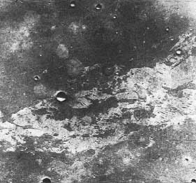
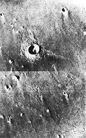
Project officials feel that the terrain in the pre-selected landing area, called Chryse, may be too hazardous. Orbiter photographs taken during the past few days reveal a much more cratered and rougher area than previously shown.
 
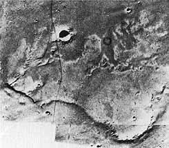
Officials want to study an area to the northwest of the primary landing site, called Chryse Phoenicia, which may be more suitable than the previously selected site.
 
A new landing date will be selected in the next several days, depending on what new information is revealed by further site investigation, officials said.
 
Additional details concerning the rescheduled landing of Viking-I will be discussed at a news briefing at the Viking News Center at 9:00 a.m., POT, Sunday.
 
Viking-1 has been orbiting the planet since June 19, faking photographs of potential landing sites.
 
 
Jim Martin met with the press Sunday morning, 27 June. "After careful examination of the landing site pictures that we have been taking for the last several days, we have decided that the A-1 area....appears to have too many unknowns and could appear hazardous." He had decided, and the NASA leadership had agreed, to postpone the touchdown while other areas were examined. He explained the A-1 northwest strategy, which if unsuccessful would be followed by a look at A-2. By going northwest, they hoped to get out of the channel, or "river bed," and into a basin, or "river delta," region. "It has been suggested that the fine material that has been washed out of the river bed....has been swept downstream and maybe has collected in this basin. If so we might expect to see sand dune fields, we might expect to see craters filled with sand or dirt.'' He hoped this could be a [337] better landing site. Noting they had always planned for such a contingency, he outlined the steps they would take during the next week.
 
After the C-1 photos became available, Martin thought the project team could draw some more decisive conclusions, but he warned the Viking specialists that even after their examinations they still might not come to understand Mars. "Things completely unknown to us" might be going on there, Martin said at the press conference. Available Mariner 9 photography indicated that A-2 was likely to be rougher than the parts of Chryse seen thus far. Unhappy as they might be, they might have to land at a point in A-1 that they did not like. "If that were to happen, we would land some time between the 8th and 12th of July." A landing at A-2 would take place on the 22d or 23d. At this time, Martin could not be more specific: he and his advisers needed more data.
 
During the question and answer session that followed the press briefing on the 27th, Martin was asked if any single factor had caused him to decide against A-1. He replied that he had been concerned since he saw the first pictures and a great deal of analysis had been done since then. Hal Masursky had been working 20 hours a day; others on the team had been putting in 16 to 18 hours daily. The telling points came at the meeting on Friday evening and the long session held that day. "I came to the conclusion last night that I had enough concerns about the safety of the landing site that I thought we must go examine additional sites."
 
No one understood how the Martian "river bed" had been formed. Masursky added to Martin's remarks that the geologists just did not have enough data to make judgments. With just one site, it was hard to say what the surface was like; they needed comparative data. The P9 photos of B-l and the P12 coverage of C-1 might help. Meanwhile. detailed analysis of existing data, including the reprocessing of photos using the computers, would give them a better idea of the terrain they were up against. 34
 
 
Men and Machines
 
 
Behind the scenes, much hard work and intense activity was under way. Viking's cameras had taken some 200 photographs by 27 June 1976, and an additional 40 covering the B-1 site were taken on the 28th. Getting these Images was no simple job. Masursky commented that many of the young people he had talked with had thought NASA's unmanned space projects were controlled by one great computer with no human beings involved. For Viking, the computers were essential, but they were only a tool to aid the scientists and engineers. As Masursky put it, "Computers are just like wearing shoes. You need them when you are walking on gravel,but they don't get you across the gravel." Viking was people interacting with the computers and with one another, and according to Masursky it was "an intensely human experience. It was young college undergraduates counting craters. Grunt work is what the photogeologists called it, but it was essential." Hour after hour, they peered through magnifying glasses, [338] counting large craters and those no bigger than a pin prick. It may have been grunt work, but to someone 17 or 18 years old it was exciting to be at the center of a major space project and know your work really counted. 35
 
Gentry Lee also talked of the persons who worked outside the lime-light. Many Viking team members thought of themselves as Earth-bound sailors guiding their ships across the vastness of space. Jim Martin and Tom Young stood in the command center, surrounded by their technical and scientific advisers. Many of these men became known to the press as they went before the microphones and cameras to explain the problems and progress of the day. Lee, Masursky, Carr, and other members of the science team became familiar faces on the evening news. Even Pete Lyman, head of the Spacecraft Performance and Flight Path Analysis Directorate, took time out from his busy schedule to brief the media on Viking's status. But many others working "in the bowels of the organization" the reporters did not see. Akin to the boiler room crew on a ship, they did all the work necessary to enable the men at the top to pick from several options; they did all the paperwork, computer programming, and system checkouts. Lee noted that he and others toward the top of the project hierarchy got positive reinforcement for their efforts; they got their names in the paper, they got their faces on television. But the stokers in the boiler room just got groused at and told to work faster and harder. At least 60 persons reworked mission blueprints every time a change was made in the proposed landing zone or in the date of the landing. But the esprit de corps was excellent because each person was doing the job for which he had trained. They were doing more than they had expected, but pride being part of the Viking team made the extra effort a matter of honor. 36
 
As things worked out, the hard work had just begun. Landing Site Staff members had to schedule their duties around noon status briefings for the press and their evening staff meetings. Sometimes working copies of mosaics were spirited off to the photo lab so that composite pictures could be released to the media. Given the strong interest and positive attitude of the news people, the photogeologists could not really complain, but such incidents were trying. It was not uncommon for new data to be delivered during staff meetings, and Masursky and his colleagues would be called on to make instant analyses before a group of several dozen specialists. Instant science became a way of life during the last days of June and early July. There was no time for idle speculation, no respite for reflection. Decisions had to be made against the clock and the mission schedules. And only human beings could make these decisions.
 
 
Which Option?
 
 
"If one sets off as Columbus did to find a new world, he would not apologize for looking for a safe harbor," Jim Martin commented to the press on 28 June. To give them some idea of the complexity of the decision making process, the next day Martin distributed to the press a "logic flow [339] diagram so each of you can be your own judge of where we should go based upon the evidence." After some laughter, he added "I kid you not. You see almost as much evidence as I do. So at each milestone you can decide which way you would go." At the two-hour Landing Site Staff meeting that evening, the attendees considered that same logic flow chart as they prepared for their big session on the 30th. 37
 
Meeting for the 13th time, for four and a half hours on 30 June, the Landing Site Staff wrestled with the three potential landing targets. During the facilities report, the men in charge noted that fatigue was beginning to catch up with some of their people. In turn, 10 specialists reported their latest information and opinions.
 
Masursky synthesized the A-1 site selection and certification process: Two and a half years earlier they had put the ellipse at the channel fronts "in the hope of getting wet sediments." This spring they had added one further northwest site, to avoid channel-borne boulders. and one northeast site, to include the best radar location. "In all of this, we did not anticipate that the channels would be incised deeply in the A-1 site region." Mariner 9 had shown gentle workings in the areas where they could now see stream cratering. Comparative crater counts showed that if they had gone to "A-1 biased" (A-1 revised. formerly called A-1S, l9.35°N, 32.5°), "we would have been in reasonable shape. There is not a significant difference between A-1 and A- 1NW. We did have to go further NW to avoid incised channels, but this is not a marked change. Our course is not dramatically different from what we set out on" two and a half years earlier. A-2 seemed less safe at the moment; knobs and craters were more predominant, according to Mariner 9 findings. In the A-1 region, Masursky said, "the ranking is straightforward. Jim Cutts' crater counts clearly show that we are moving in the right direction. The choice is heavily weighted to the NW." The sun elevation, however, was somewhat higher in the P8 and P10 pictures than in P1 and P6, and lunar experience indicated that as the sun went up craters disappeared from photos.
 
Overall, Masursky rated the sites: A-2, worst. A-1 revised, next. A-1 NW, best from available data, the most favorable site at the moment.
 
When Masursky finished his summary, Tom Young asked for a vote by those who had experience or a feel for the factors. No one present was ready to land at A-1 revised. Thirty specialists favored A-1 northwest, while two wanted to go to A-2. Three abstained-Carl Sagan, Len Tyler, and Henry Moore-because there were not enough data to make a decision. Under questioning, Sagan said if he had to he would vote for science and choose A-I revised. Tyler was strongly negative to A-I revised and said that A-I northwest and A-2 looked equally good. Moore favored A-1 northwest and A-2. If Arecibo radar confirmed the site, he would vote for A-1 northwest, but he just did not feel comfortable about trying to land without radar. Jim Martin closed the meeting by reminding the group that he had not made his decision, because not all the P10 photos were available yet. 38


[340] Views on 27 June 1976 of the A-1 NW Chryse Planitia site, an alternative to the A-1 landing site on Mars, did little to relieve Viking team worries. Viking I's close look, in the two orbiter frames at left, reveals an impact crater, ejecta blanket, many small craters with wind tails (probably dunes), fractures, and knobs of rock. Above, the irregular south edge of a plateau appears to have been shaped by the flow of water.


Fifty-three persons attended the project manager's 8 a.m. landing site meeting on l July. Without "rehashing" the previous night's meeting, Martin wanted to hear any new information from those who had been working all night, and then he wanted another vote. In the course of the discussion, it became apparent that the worrisome factor was the Arecibo radar observations scheduled for 4 and 5 July. John Naugle from headquarters asked the assembled specialists how bad the radar at A-1 northwest had to be "to make us go to A-2." Len Tyler said it was difficult to anticipate the results. If the data were similar to the Goldstone results for A-1, he thought they should go to A-2. Carl Sagan thought that two different situations were possible at A-1 northwest-good quality pictures with mediocre quality radar, or good quality radar with mediocre pictures. For safety, he wanted to see both good-quality radar and good-quality photographs. After some additional discussion of radar by Von Eshleman, Martin called for a show of hands. All present were asked to vote, and to discourage fence-sitting he told them that anyone who abstained would have to explain his position. Should they try to land at A-1 revised? No hands were raised. Should they try for A-1 northwest? All but one voted for this option: he favored the third possibility. A-22. 39
 
At the noon briefing, Administrator Fletcher and Jim Martin talked with the press. Fletcher congratulated Martin and his people for their hard work and their apparent success in finding a safe landing site in what the [341] Administrator called the ``Northwest Territory'' (A-1 NW). Martin reported that the flight team was working toward a landing on 17 July at 3 a.m. PDT. Looking back later, Martin said it had been very troubling to find geological features that the specialists neither expected nor understood. On Friday, 25 June, when the landing team was still struggling with the question of what was going on in that area. Dr. Bob Hargraves from Princeton had made a suggestion that caught Martin's attention. If you do not like this river bed area from which material has been excavated, look for the area where that debris has been deposited. "We started thinking about where that river went." Since the river bed seemed to be going off to the northwest. "that prompted our decision against landing at A-1." 40
 
Gentry Lee and Hal Masursky had vivid recollections of that event. Lee commented on the decision to go northwest: "I distinctly remember the point where I believe Jim Martin changed his mind because I may have been an hour or two ahead of him....It wasn't exactly as if light bulbs went off, but Bob Hargraves has a way at times of explaining things in such a- especially big geologic things-in such a way that it becomes very clear." Masursky thought it ironic that the leader of the magnetic properties team could make so easily a point that he, the leader of the landing site certification team, had been trying to get across for 18 months. But when Hargraves had said, "Let's go downstream," it had come at precisely the proper moment for Martin to react. Since Bill O'Neil and his navigators had already worked out the procedures beforehand at Masursky's suggestion, the Landing Site Staff had been able to move quickly once it had decided in which direction to move. 41
 
Between l and 6 July, as the project team waited for the Arecibo results, the Landing Site Staff continued to evaluate existing information. During an afternoon meeting on the 6th, Tyler telephoned from Stanford, where the Arecibo data were still being analyzed. Generally, the results seemed to corroborate earlier observations that the topography between 30° and 50° longitude was rough-A-1 northwest was at 43°. Farther to the west, it seemed to get smoother. The news was not reassuring. 42
 
 
Renewed Crisis
 
 
Two crucial meetings were held 7 July. At 8 a.m. PDT, Len Tyler presented the results of the Arecibo radar observations of early July. His remarks were essentially the same as those given over the telephone the previous afternoon:
 
 
Observations-
 
1) Good data obtained from Chryse Planitia July 3,4. Data to West and to the East obtained July 2 and 5 respectively.
 
2) July 3 and 4 provide detailed repeatable results from 41° to 46°W with integrations as short at 0.7° in longitude.
 
 
[342] Results-
 
3) One-half power widths generally corroborate Carpenter['s 1967 observations]. Generally rough between 35° and 50°W, smoother to the East and to the West; with general quantitative agreement.
 
4) Chryse Planitia is a complex radar area, generally of roughness comparable to area observed by Arecibo SW of A-1 (33°37°W. 17.5°N). On the average. Chryse Planitia and SW A-I are not distinguishable by the current observations.
 
5) Spectra from Chryse Planitia on both July 3 and 4 show a sharp drop (2:1) in total reflectivity at about 44°W (23.2°N). This is interpreted as a marked increase in roughness and/or decrease in reflectivity at that location. However, the apparent abruptness of the change cannot be understood in terms of a simple two-unit model for the scattering, indicating the complexity of the area. (One needs to build specialized models to explain such abrupt behavior on spectra averaging over wide areas.)
 
6) Spectra from Chryse Planitia on both July 3 and 4 show a "spike" corresponding to approximately 42°W, suggestive of a smoother area near that longitude.
 
7) There is no area within the regions probed in Chryse Planitia, of size greater than about 3° in diameter, as smooth as the Martian average (assuming that the reflectivity is not also anomalously low).
 
 
Radar was saying that the surface was rough where the photographs had indicated it was smooth. The question was which to believe-whether photos you can see, but at a scale larger than the lander, or radar, which produces only spectral lines on graph paper but which supposedly has "felt" the surface. Tyler's conclusions were that the southwestern and northwestern regions of A-1 were twice as rough as the Martian average and that west of 50° the surface was back to average. Tom Young closed the morning session by summarizing their choices: (a) Go to A-1 NW. (b) Go to A- 1WNW-because of new radar results, no Viking visual imaging. (c) Go to A-2-because of old radar, no Viking visual imaging. "We may be surprised at A-2 and there is a timeline problem." Young sent the Landing Site Staff off to study these options before they reconvened at 4 p.m. 43
 
Jim Martin summed up the new situation for the press at noon: "The visual images are only really telling us what is observable at....100 meters and up.... Rose Bowl size hazards." Tyler and his colleagues believed that radar "feels slopes, boulders, in the order of a meter or a few meters in size.'' Martin and his men had a decision to make that night-go ahead with the plans for a 17 July landing or use the next day's maneuver to look for a new site in the 50° longitude area. The map looked good, but no detailed photographs had been taken in that region. Should a decision be made to look farther west, any landing would he delayed another three to five days. He believed that the radar data looked good; the problem was one of [343] interpretation, and he had to admit that there were differences of opinion as to what the radar was telling them. 44
 
Martin, presiding at the 18th Landing Site Staff meeting the night of 7 July, opened by saying: "We must move forward, if not to land, to do other things. We must today tell" the Spacecraft Performance and Flight Path Analysis Directorate what direction (east or west) to go tomorrow. "The outcome of these discussions will be to continue to 23 1/2°N and 43 1/2°W (the A-1NW site), or go over and observe farther west....We must be prepared to continue beyond 6 p.m. tonight to air all viewpoints."
 
Tom Young took the floor. The fifth Mars orbit trim maneuver had to he executed at 5 the next evening. ``We will correct latitude and walk [move the spacecraft] westward. If we decide tonight for A-1 NW, we can land on July 17.1f we decide to go to WA-lNW [west A-1 northwest], we keep on walking, and land at WA-1NW about July 20 plus one or two days." The calendar of events was a full one:
 

Thursday, 8 July

P-19, Mars orbit trim 5.

Friday, 9 July

P-20, take 80 frames of monoscopic reconnaissance coverage of WA-1NW to 55°, contiguous to the P-10 coverage.

Saturday, 10 July

P-2l, photo coverage.

Sunday, 11 July

P-22, 80 frames contiguous to P-20 coverage.

Wednesday, 14 July

P-24, accept or reject area covered in P-20 and P-22.

Thursday, 15 July

P-25, Mars orbit trim 6.
or Friday, 23 July
P-33, Return to A-1NW and land there.

And photography versus radar continued to be a dilemma. Site A-1NW assessment by radar was that it was "bad"; by photos, "good." Site WA-1NW radar assessment was "good," but no photos would be available until P-20 and P-22. Good photos to accompany the good radar of the "far west" would mean a landing there. Bad photos and good radar would mean going back to A-1 northwest. It was obvious that it was difficult to say exactly what the various radar signal returns meant. Sometimes the Landing Site Staff could say with assurance that a particular signal reduced to spectral lines on a graph equaled a specific terrain. Other spectra were just not fully understood. Tyler was the first to say that he did not "want to land without images" of the landing site. Young gave the group two choices-A-1 northwest on 17 July, or go west to west A-1 northwest and try for a landing on the 20th. If the pictures there were bad, return to A-1 northwest and land on the 23d.
 
The vote, when it came, totaled 23 for site A-1NW and 12 for going west. Essentially, the voting indicated that the scientists were ready to land [344] anywhere and get on with the mission. Landing site and project staff members, surprised by this vote, were still playing it cautious and wanted to look at another location before chancing a landing. Martin told the group he would make public his decision that night. 45 That evening the Viking news center at JPL released a mission status report:
 
NASA officials have decided to study a possible new landing area on Mars, some 575 kilometers (365 miles) further west than the previously planned site. This will delay the landing of Viking l at least until July 20.
 
New radar results obtained July 3 and 4 at Arecibo Observatory indicate that a more westerly area of Chryse Planitia may be smoother than the previously selected northwest site. This area....has not yet been photographed by Viking.
 
Viking l will perform an orbital trim maneuver at approximately 5 p.m. PDT, Thursday, July 8. to begin moving the spacecraft over to the western region, where high resolution photographs will be taken Friday, July 9, and Sunday. July 1l.
 
If these photographs indicate agreement with the recent radar data, the landing can occur as early as July 20. 46
 
Martin gave further details the next day at noon, and Len Tyler briefed the press on the complex business of radar observation and the interpretation of data. He tried to explain such terms as rms slope , "root mean square" being a specific kind of mathematical average. He talked about sending a radar beam out to Mars and then 36 minutes later measuring the nature of the reflected signal. Using the analogy of a spotlight he said:
 
If Mars were perfectly smooth, one would see a single spot....that's about one kilometer in size. That spot would be bright; otherwise Mars would be dark. As you roughen the surface of the planet this single spot breaks up into a multitude of smaller spots so that one sees a speckle pattern around the....radar point....This pattern would be bright and otherwise the planet would be quite dim.....As you increase the roughness....the size of the speckle pattern increases. So a very smooth location on Mars will produce a very tight pattern, and a very rough location produces a broader pattern.
 
While roughness affected the pattern of the reflected signal, it did not affect Its strength. On the other hand. the nature of the surface-hard to soft- influenced the returned signal's power. The Arecibo data indicated a rougher-than-average surface beneath the radar spot when it was aimed at A-1 northwest. With these results the same as Haystack's radar findings of nine years earlier, Tyler had voted to go farther west. 47
 
When it was his turn to speak, Hal Masursky frankly indicated that he was puzzled at the discrepancy between the photographs and radar observations. He noted that "if our backs were to the wall we would have....[taken] the increased risk of attempting to land in this small area embedded between the radar rough areas" at A-1 northwest. "But since we have the chance of looking just to the west....where the radar spectra shows much sharper, cleaner echo, then it seemed prudent to take the additional series of [345] pictures." To put a landing ellipse in a safe part of the A-1 northwest region. "we'd have to put at least half of it outside the photographic coverage and again that didn't seem like a good idea." So Masursky also wanted to look further before committing Viking 1 to a final landing place. 48
 
 
Viking l Landing Site Decision
 
 
The fifth-orbit trim maneuver was executed just before 6 pm PDT on 8 July. After loading the spacecraft's computer memory with the maneuver command, ground controllers had temporarily lost contact with Viking for an expected blackout period, from 4:40 to 6:13 p.m. Viking 1 performed the 40.77-second engine burn flawlessly and was on its way to look at the "far west." The next day for important decisions would be 14 July, by which time the P20 and P22 photos would be fully evaluated. Then the project team could choose between west A-1 northwest and A-1 northwest.
 
Meanwhile, the Landing Site Staff was trying to draw conclusions about the B and C sites for Viking 2 . On 8 July, Barney Farmer reported on his atmospheric water studies over the Capri region (C-1 at 5°S); at this season of the year it appeared warm and dry, not biologically promising. Farmer remarked that if he had his choice free from all other constraints he would land at Hellas Planitia, which because of its low elevation (high pressure offered the probability of more water and higher temperatures than other sites. His description of Capri led to a phrase popular with the specialists-it was "hotter than Hellas." 49
 
On the 12th, the site staff met to consider the insights for the Viking 1 site gained up to that point from the P10, P20, and P22 photographs. John Guest of the University of London had reviewed the revised and updated geology hazard map and found that neither textured surface nor grooved plains existed in the landing ellipse, except possibly some fine grooving below the resolution limit of the cameras. Additionally, channels disappeared or stopped rather suddenly, and Guest thought this indicative of their being covered over by wind- or water-borne dust or larger particles (a process called mantling) rather than their being below the resolution limit. Hal Masursky believed that existence of this younger, thicker mantling was consistent with the drop in radar reflectivity in that direction. Norm Crabill noted in the meeting minutes, "As we go west, we get into older geologic units and sharper reflectivity, with sharper features appearing further west." Masursky believed that they had reached the best location for a landing. He reported that although the slopes in the new ellipse (47.5° longitude) were as bad as those in A-1 the radar reflectivity was better. Significantly, this region seemed to have relatively few young impact craters, which meant that the area was probably covered with weathered materials that would pose less of a hazard to the lander.
 
Len Tyler presented findings from the continued radar analysis. Tongue in cheek, he suggested that the reflected signals dropped off significantly [346] either because of scattering caused by the surface or because of a hole through the planet. But, despite the "Chryse Anomaly," he noted that the surface looked better at 47¡ to 48¡. Radar data were once again the subject of considerable discussion among the specialists, hot after a couple of hours Martin closed the session. They would reconvene that night to consider the additional P22 pictures processed by then and reach a decision. If they could not do so quickly, they would meet at 3:00 the next morning and continue to meet until they selected a landing site. Some tempers and senses of humor were wearing thin, but Martin continued to display his steady, firm, authoritative manner. A decision needed to made, and he intended to see it through.
 
Hal Masursky opened that night's session. He saw three possible landing areas: alpha, at 22.4°N, 47.5°; beta, at 22.5°N, 49.0°; or gamma, at 22.0°N, 51.0°. After the staff had moved ellipses around the photomosaics (playing what Masursky called "cosmic ice hockey"), counted hazards, and evaluated radar, alpha looked best. Mike Carr expressed an opinion held by several attendees at that late meeting on 12 July, "Don't prolong the debate, the choice is clear." Too often, he thought, meetings had lasted a specific number of hours simply because it was traditional for them to last that long. He was ready to force the vote.
 
The alpha site would be a compromise between the hazards visible in the photographs, primarily impact craters and the blocks ejected from them, and the small-scale surface properties "felt" by the radar. A vote was called for, and alpha, at 22.5° north latitude, 47.5° longitude, was the unanimous choice for the spot to land Viking 1 . The 22d meeting of the Landing Site Staff adjourned at midnight. 50 Mike Carr reflected that he never had any second thoughts once the decision had been made. "I didn't realize how great a strain it had been on me....When the decision was finally made it was as though a tremendous load went off." 51
 
With site certification completed on the 12th and the spacecraft's orbit adjusted on the 16th, the project focused its attention on preparing for a 20 July landing. Final descent trajectory information and minor sequence changes were sent to the orbiter, and a set of commands for entry, landing, and the preprogrammed mission was transmitted to the lander. The same set of commands was transmitted to the Lander Support Office at Martin Marietta, where a computer-simulated mission was being flown.
 
At 5:12 a.m. PDT on 20 July 1976, the seventh anniversary of man's first stepson the moon, the Landing Site Staff learned that the Viking 1 lander had touched down safely on Mars 19 minutes earlier. The job half done, the staff continued to evaluate sites for the second spacecraft.