-
On Mars:
Exploration of the Red Planet. 1958-1978
-
-
-
- EVOLVING A CERTIFICATION
PROCESS
-
-
-
- [323] Along with radar and C site
problems, site certification remained an open issue. In late May
1975, the Viking Project Office released one of the major products
of the Landing Site Staff, a draft of the "Site A-1 Certification
Procedure." This document described how the landing specialists
would establish the acceptability of A-1 for landing and how they
would....
-
-
-
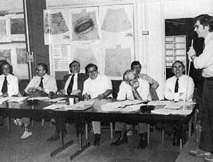
- During the 24 February 1975 landing
site working group meeting, Len Tyler explains his complex radar
studies of the Martian surface to (left to right) B. G. Lee,
William Michael, Thomas Mutch, Don Anderson, Richard Shorthill,
Gary Price, and Robert Hargraves.
-
-
- [324]....recommended a target point that
maximized the probability of a safe touchdown. Their
recommendations would be based primarily on their analyses of
low-altitude photographs taken during the first 10 orbiter
revolutions. Key to the certification process would be the
stereophotographic swaths of the A-1 site taken during the fourth
and sixth revolutions - called P4 and P6 photos, as the
revolutions were numbered from Viking's periapsides. After
playback on video recorders, reconstruction, image processing, and
enhancement, these photo frames, in the form of stereo pairs,
would be analyzed at the U.S. Geological Survey's Flagstaff
facility where ground elevation, slope angles. and surface
roughness would be estimated. This information would be used with
photo mosaics made from the orbiter frames to produce geologic
maps of the proposed landing site region. Earth-based radar and
telescopic observations, oblique and high-altitude photos, as well
as Mars atmospheric-water detector and infrared thermal- mapping
coverage of the landing site region, would provide supportive
information about the nature of the surface. From this data base,
landing site specialists would prepare a safety assessment report
of the target zone.
-
- During the site certification process, the
Landing Site Staff would provide a series of recommendations. Just
before the craft inserted into orbit of Mars, the team would
decide either to execute the normal insertion maneuver and proceed
with data acquisition or to modify the maneuver if a dust storm or
some other anomaly were detected during approach. After playback,
processing, and inspection of the imaging system frames from a
pass over the A-1 site, it might be necessary to adjust the timing
of the orbit or the pointing of the camera platform to obtain
optimum coverage of the site on subsequent passes. Four such
data-acquisition-adjustment opportunities were planned that would
affect the camera sequences at or near P3, P4, P6, and P10. The
Viking team would then have to answer the crucial question: would
it land the craft or reject the site the team had selected?
Recommendations would be made at three points before lander
separation from the orbiter. A preliminary commitment to A-I would
be made seven days before separation (at about P9), based on a
preliminary assessment of available data. A firm commitment to
land would be made three days later, and a precise target point
would be established. A final commitment to land, made just before
separation, would be determined after examining photos taken
during the previous five days to confirm the absence of dust
storms and high winds. 12
-
- In the time that remained before the
spacecraft reached Mars, the Landing Site Staff continued
extensive preparations for completing site certification and
lander release. In June and July, a functional test checked the
ground-based hardware that would process photos from the orbiter
and make the photomosaics and maps. The weakest link in the
several-hundred-million-kilometer chain from Mars to the photo
analysis labs in northern Arizona seemed to be the 850 kilometers
the photographs traveled across the western U.S. Continental
Trailways bus express, a leased army [325] aircraft and datafax
were used to strengthen connection between Los Angeles and
Flagstaff. The team did parts of the test a second time, verifying
the readiness of the processing equipment and the personnel.
13
-
- During the last months of 1975 and early
1976, the staff gave considerable attention to timing. Since so
much depended on timely certification, scheduling became a
paramount concern. The landing site specialists, working closely
with the mission design team and the orbiter performance and
analysis group, were ready by early February 1976 to test the
timeline in what they called the ``SAMPD- l'' test, an exercise
developed by B. Gentry Lee's Science Analysis and Mission Planning
Directorate. 14
-
-
-


