Uranus III
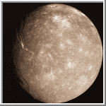
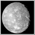
Titania [Ty-TAY-ne-ah] is the largest moon of Uranus. It is marked by a few large impact basins, but is generally covered with small craters and very rough rocks. The above image shows a 1,600 kilometer (1,000 mile) long trench. A large double walled crater can be seen towards the top of the image. There are many faults on Titania indicating there has been internal forces molding its surface.
| Titania Statistics | |
|---|---|
| Discovered by | William Herschel |
| Date of discovery | 1787 |
| Mass (kg) | 3.49e+21 |
| Mass (Earth = 1) | 5.8400e-04 |
| Equatorial radius (km) | 788.9 |
| Equatorial radius (Earth = 1) | 1.2369e-01 |
| Mean density (gm/cm^3) | 1.70 |
| Mean distance from Uranus (km) | 435,840 |
| Rotational period (days) | 8.705872 |
| Orbital period (days) | 8.705872 |
| Mean orbital velocity (km/sec) | 3.65 |
| Orbital eccentricity | 0.0022 |
| Orbital inclination (degrees) | 0.14 |
| Escape velocity (km/sec) | 0.768 |
| Visual geometric albedo | 0.27 |
| Magnitude (Vo) | 13.73 |
 Titania
This image of Titania shows a 1,600 kilometer (1,000 mile) long trench located
towards the left side of the picture. A large double walled crater can be seen
towards the top of the image.
(Credit Calvin J. Hamilton)
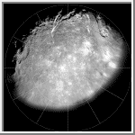
 Polar Stereographic Map of Titania
This image is a polar stereographic map of the southern hemisphere of Titania.
The map was made from the three highest resolution clear filter
images taken by Voyager 2. The two best images were averaged
in order to decrease the noise. The resulting image and the
third highest resolution clear image were then projected into a polar
stereographic projection and mosaicked together. Zero degrees longitude (the
central longitude of the side that is facing Uranus) is at the top.
(Courtesy A.Tayfun Oner)
 Mercator Map of Titania
This image is a mercator map of Titania. The map covers
from 70 to -70 degrees latitude with 0 degree longitude located at the
center. The scale is 5 pixel/degrees at the equator.
(Courtesy A.Tayfun Oner)
 Global Orthographic View of Titania
This global orthographic view of Titania is centered at 60° south latitude and
340° longitude. The image is a reprojection of the polar stereographic map.
(Courtesy A.Tayfun Oner)
 Crescent Orthographic View of Titania
This crescent orthographic view of Titania is centered at 20
degrees north latitude and 340 degrees longitude. 340 degrees longitude
is directed towards the right side of the image.
(Courtesy A.Tayfun Oner)

 Uranus
 Umbriel
 Oberon